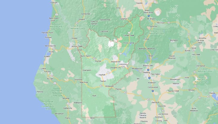
Cities and Towns in Trinity County, California
Founded in 1850, Trinity County is one of 58 counties in the state of California. The city of Weaverville is the county seat. With FIPS code of 105, Trinity County has a population of 16,060 and area of 3,179 square miles (8,234 km²).
List of all cities in Trinity County, CA alphabetically
City/Town | Postal Code | Area Code |
Big Bar, CA | 96010 | 530 |
Burnt Ranch, CA | 95527 | 530 |
Douglas City, CA | 96024 | 530 |
Hayfork, CA | 96041 | 530 |
Helena, CA | 96048 | 530 |
Hyampom, CA | 96046 | 530 |
Junction City, CA | 96048 | 530 |
Lewiston, CA | 96052 | 530 |
Mad River, CA | 95552 | 707 |
Peanut, CA | 96041 | 530 |
Salyer, CA | 95563 | 530 |
Trinity Center, CA | 96091 | 530 |
Weaverville, CA | 96093 | 530 |
Zenia, CA | 95595 | 707 |
Major Cities and Towns in Trinity County, California
Weaverville
- Area: 10.1 square miles
- Population: 3,600 (2020 Census)
- ZIP Codes: 96093
- Latitude and Longitude: 40.7368° N, 122.9411° W
Location and History
Weaverville, the county seat of Trinity County, California, is located in the picturesque Trinity Alps, surrounded by lush forests and mountainous terrain. Established during the California Gold Rush in 1850, Weaverville quickly became a bustling mining town, attracting thousands of prospectors seeking their fortunes in the gold-rich streams and rivers. The town’s name honors John Weaver, one of the area’s earliest settlers and a prominent miner. Weaverville retains much of its historic charm, with many buildings from the Gold Rush era still standing, including saloons, storefronts, and homes. The town’s rich history is reflected in its well-preserved architecture and vibrant community events that celebrate its past. Over time, Weaverville has evolved into a peaceful mountain town that serves as a gateway to outdoor recreation in the Trinity Alps and along the Trinity River.
Major Schools and Landmarks
Weaverville is served by the Trinity Alps Unified School District, which includes Trinity High School, known for its strong academic programs and active involvement in athletics and arts. Major landmarks in Weaverville include the Weaverville Joss House State Historic Park, home to the oldest continuously used Chinese temple in California, which reflects the significant Chinese immigrant population that played a crucial role in the town’s early development. The Jake Jackson Memorial Museum offers a glimpse into Weaverville’s rich Gold Rush history, with exhibits featuring artifacts, photographs, and historical documents. The nearby Trinity Alps Wilderness area provides extensive opportunities for hiking, camping, and fishing, attracting outdoor enthusiasts from across the region. Weaverville’s annual events, such as the Fourth of July Parade and the Trinity County Fair, celebrate the town’s community spirit and historical legacy, making it a vibrant and welcoming place in Trinity County.
Hayfork
- Area: 72.6 square miles
- Population: 2,368 (2020 Census)
- ZIP Codes: 96041
- Latitude and Longitude: 40.5518° N, 123.1825° W
Location and History
Hayfork is a small, rural town located in the southern part of Trinity County, California, nestled in the Hayfork Valley. The town was established in the mid-19th century during the California Gold Rush, with early settlers attracted by the fertile valley and the nearby gold deposits. Hayfork’s name is derived from the nearby Hayfork Creek, which runs through the valley. The town developed as an agricultural community, with farming, ranching, and timber harvesting playing significant roles in the local economy. Hayfork has maintained its rural character over the years, with a strong emphasis on community, self-sufficiency, and a connection to the land. The town is surrounded by the Shasta-Trinity National Forest, offering stunning natural beauty and a peaceful, laid-back lifestyle.
Major Schools and Landmarks
Hayfork is served by the Mountain Valley Unified School District, which includes Hayfork High School, a small school known for its close-knit community atmosphere and strong focus on academics and extracurricular activities. Major landmarks in Hayfork include the historic Hayfork Hotel, a relic of the town’s early days, and the Hayfork Park, which offers recreational facilities and hosts community events. The annual Hayfork Farmers Market is a popular event, showcasing local produce, crafts, and products from the surrounding farms and ranches. The town is also a gateway to the nearby Yolla Bolly-Middle Eel Wilderness, providing opportunities for hiking, camping, and exploring the rugged wilderness of Northern California. Hayfork’s rural charm, community spirit, and natural surroundings make it a quintessential example of small-town life in Trinity County.
Lewiston
- Area: 18.7 square miles
- Population: 1,222 (2020 Census)
- ZIP Codes: 96052
- Latitude and Longitude: 40.7046° N, 122.8089° W
Location and History
Lewiston is a small town located in the northern part of Trinity County, California, near the Lewiston Lake and the Trinity River. Established during the Gold Rush in the early 1850s, Lewiston served as a hub for mining activities along the Trinity River. The town was named after Lewis, a miner who was among the first to settle in the area. Lewiston quickly became a supply center for miners working in the surrounding hills and along the river. As the gold rush subsided, the town transitioned to a quieter, more rural community, with an economy based on agriculture, ranching, and tourism. The construction of the Lewiston Dam in the 1960s created Lewiston Lake, which has since become a popular destination for fishing, boating, and outdoor recreation.
Major Schools and Landmarks
Lewiston is served by the Lewiston Elementary School District, with students attending Lewiston Elementary School before moving on to schools in nearby Weaverville for higher grades. Major landmarks in Lewiston include the historic Lewiston Hotel, a well-preserved building from the town’s early days, and the Trinity River, which offers excellent opportunities for fishing, particularly for trout and salmon. Lewiston Lake, created by the Lewiston Dam, is another significant landmark, providing a peaceful setting for boating, fishing, and picnicking. The nearby Trinity Alps Wilderness offers a wide range of outdoor activities, including hiking, backpacking, and wildlife viewing. Lewiston’s annual events, such as the Lewiston Peddler’s Fair, celebrate the town’s community spirit and historical legacy. The town’s blend of historical significance, natural beauty, and rural tranquility makes Lewiston a unique and inviting place in Trinity County.
Trinity Center
- Area: 3.1 square miles
- Population: 267 (2020 Census)
- ZIP Codes: 96091
- Latitude and Longitude: 40.9836° N, 122.7086° W
Location and History
Trinity Center is a small community located in the northern part of Trinity County, California, near the shores of Trinity Lake. The town was originally established during the Gold Rush in the 1850s as a mining camp, and its location near the Trinity River made it an ideal spot for gold panning and mining operations. As the gold rush faded, the town became a quieter, more rural community focused on agriculture and ranching. The construction of the Trinity Dam in the 1960s created Trinity Lake, transforming the area into a popular destination for outdoor recreation, including boating, fishing, and camping.