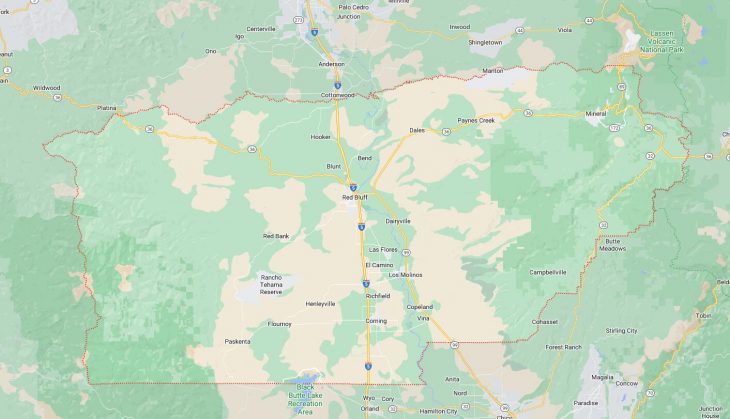
Cities and Towns in Tehama County, California

Founded in 1856, Tehama County is one of 58 counties in the state of California. Historically, Tehama County was formed from Butte, Colusa and Shasta. The city of Red Bluff is the county seat. With FIPS code of 103, Tehama County has a population of 65,498 and area of 2,951 square miles (7,643 km²).

List of all cities in Tehama County, CA alphabetically

City/Town Postal Code Area Code
Corning, CA 96021 530
96029 530
Dairyville, CA 96080 530
Flournoy, CA 96029 530
Gerber, CA 96035 530
Lassen Volcanic National Par, CA 96063 530
Los Molinos, CA 96055 530
Manton, CA 96059 530
Mill Creek, CA 96061 530
Mineral, CA 96061 530
96063 530
Paskenta, CA 96074 530
Paynes Creek, CA 96075 530
Proberta, CA 96078 530
Red Bluff, CA 96080 530
Tehama, CA 96090 530
Vina, CA 96092 530

Major Cities and Towns in Tehama County, California

Red Bluff

Area, Population, and Geography

  • Area: 7.68 square miles
  • Population: Approximately 14,000 (2023 estimate)
  • Zip Codes: 96080, 96001
  • Latitude: 40.1785° N
  • Longitude: 122.2358° W

City Location and History

Red Bluff, the county seat of Tehama County, is located in Northern California, about 30 miles south of Redding and 120 miles north of Sacramento, along the Sacramento River. The city was originally established as a transportation hub during the California Gold Rush due to its location on the river, which was navigable by steamboats at the time. Named for the reddish bluffs that overlook the river, Red Bluff grew rapidly as a center for the wool, lumber, and cattle industries. The city retains much of its historic charm, with several preserved buildings from the 19th century still standing. Today, Red Bluff is known for its annual Red Bluff Round-Up, one of the largest rodeo events in the country, which draws visitors from all over.

Major Schools and Landmarks

Red Bluff is home to several schools, including Red Bluff High School and Vista Preparatory Academy. The city’s landmarks include the historic Tehama County Courthouse, which was built in 1920, and the Kelly-Griggs House Museum, a Victorian-era home showcasing local history. The nearby Sacramento River Bend Area offers recreational opportunities such as fishing, hiking, and camping, while the Red Bluff Recreation Area along the river is popular for boating and picnicking. The city’s downtown area features several antique shops, restaurants, and the beautifully restored State Theatre, which hosts various cultural events.

Corning

Area, Population, and Geography

  • Area: 3.55 square miles
  • Population: Approximately 8,000 (2023 estimate)
  • Zip Codes: 96021, 96029
  • Latitude: 39.9279° N
  • Longitude: 122.1797° W

City Location and History

Corning is located in the southern part of Tehama County, approximately 19 miles south of Red Bluff and 100 miles north of Sacramento, near the intersection of Interstate 5 and Highway 99. The city was founded in 1887, primarily as a railroad town when the Southern Pacific Railroad extended its line through the area. Corning quickly became known as the “Olive City” due to its extensive olive orchards, and it remains one of the leading producers of olives and olive oil in the United States. The town’s agricultural roots are still evident today, with many of its residents involved in farming and related industries. Corning is also known for its strong community spirit and annual events that celebrate its heritage.

Major Schools and Landmarks

Corning Union High School and Maywood Middle School are among the city’s educational institutions, serving the local population. The city is home to several unique landmarks, including the Corning Olive Festival, the oldest olive festival in the country, which celebrates the town’s agricultural history. Woodson Bridge State Recreation Area, located along the Sacramento River, is a popular spot for camping, fishing, and bird-watching. Additionally, Corning is known for the Rolling Hills Casino, which offers entertainment, dining, and gaming, attracting visitors from across the region. The city’s charming downtown area, with its historic buildings and small-town atmosphere, also provides a glimpse into its rich past.

Tehama

Area, Population, and Geography

  • Area: 0.8 square miles
  • Population: Approximately 420 (2023 estimate)
  • Zip Codes: 96090
  • Latitude: 40.0265° N
  • Longitude: 122.1236° W

City Location and History

Tehama, one of the smallest incorporated cities in California, is located in central Tehama County, along the banks of the Sacramento River. Situated about 18 miles southwest of Red Bluff, Tehama was one of the first communities established in the county, dating back to the early 1850s. It served as a significant shipping point on the Sacramento River during the Gold Rush era, with goods and passengers traveling by steamboat between Sacramento and the northern mines. Despite its small size, Tehama has a rich history and played an important role in the development of the region. Today, it is a quiet, rural community known for its close-knit atmosphere and scenic river views.

Major Schools and Landmarks

Given its small size, Tehama does not have its own schools, with students typically attending schools in nearby communities like Los Molinos. The city’s most notable landmark is the Sacramento River, which provides opportunities for fishing, boating, and nature walks. The Tehama Bridge, originally built in 1911 and later replaced, serves as a historic crossing over the river and connects the town to other parts of the county. The surrounding countryside, with its rolling hills and agricultural fields, offers picturesque landscapes that reflect the area’s rural charm and historical significance.

Los Molinos

Area, Population, and Geography

  • Area: 2.3 square miles
  • Population: Approximately 2,000 (2023 estimate)
  • Zip Codes: 96055
  • Latitude: 40.0227° N
  • Longitude: 122.0983° W

City Location and History

Los Molinos is a small, unincorporated community located in eastern Tehama County, approximately 10 miles southeast of Red Bluff, along Highway 99. The town was established in the early 20th century as a result of the expansion of agriculture and the arrival of the railroad. The name “Los Molinos,” which means “The Mills” in Spanish, reflects the early presence of mills in the area that processed grain from the surrounding farms. Over the years, Los Molinos has remained a predominantly agricultural community, with its economy largely based on farming, particularly the cultivation of orchards and vineyards. The town is known for its rural lifestyle, friendly residents, and agricultural fairs.

Major Schools and Landmarks

Los Molinos Unified School District serves the educational needs of the community, with Los Molinos High School being the main secondary institution. The town is surrounded by fertile farmland, with landmarks such as the nearby Mill Creek, a popular spot for fishing and outdoor recreation. Another significant landmark is the Los Molinos Veterans Hall, which serves as a community center and hosts various local events. The town’s annual Almond Blossom Festival is a major event, celebrating the blooming of almond trees, which are a key crop in the area. The peaceful, rural atmosphere of Los Molinos makes it a quintessential example of small-town life in Northern California.

Map of Cities in Tehama County, CA

Map of Cities in Tehama County, CA