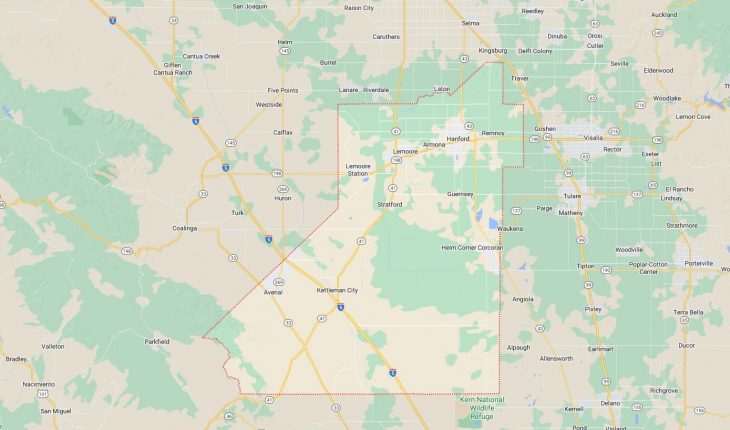
Cities and Towns in Kings County, California
Founded in 1893, Kings County is one of 58 counties in the state of California. Historically, Kings County was formed from Tulare. The city of Hanford is the county seat. With FIPS code of 31, Kings County has a population of 153,443 and area of 1,390 square miles (3,600 km²).
List of all cities in Kings County, CA alphabetically
City/Town | Postal Code | Area Code |
Armona, CA | 93202 | 559 |
Avenal, CA | 93204 | 559 |
Corcoran, CA | 93212 | 559 |
Hanford, CA | 93230 | 559 |
93232 | 559 | |
Kettleman City, CA | 93239 | 559 |
Lemoore, CA | 93245 | 559 |
93246 | 559 | |
Lemoore Naval Air Station, CA | 93245 | 559 |
93246 | 559 | |
NAS Lemoore, CA | 93246 | 559 |
Stratford, CA | 93266 | 559 |
Us Naval Air Station, CA | 93246 | 559 |
Major Cities and Towns in Kings County, California
Hanford
Area, Population, and Geographic Coordinates
- Area: 16.6 square miles
- Population: Approximately 57,703 (as of 2020)
- Zip Codes: 93230, 93232
- Latitude: 36.3275° N
- Longitude: 119.6457° W
Location and History
Hanford is the county seat and largest city in Kings County, located in the San Joaquin Valley. The city was founded in 1877 as a rail stop on the Southern Pacific Railroad and was named after James Madison Hanford, a railroad official. Hanford quickly grew as a center for agriculture, benefiting from the fertile soil of the surrounding valley. The city became an important commercial hub for the region, with its economy historically based on dairy farming, cotton, and other crops. Hanford’s historic downtown, with its well-preserved buildings, reflects the city’s rich heritage. The city’s growth continued throughout the 20th century, driven by both agriculture and the presence of the nearby Naval Air Station Lemoore, one of the largest naval air stations in the United States.
Major Schools and Landmarks
Hanford is served by the Hanford Joint Union High School District and the Hanford Elementary School District, with notable schools including Hanford High School and Sierra Pacific High School. Major landmarks in Hanford include the Hanford Carnegie Museum, housed in a historic Carnegie Library building, and the Fox Theatre, a restored 1920s movie palace that hosts live performances and community events. The nearby Hidden Valley Park offers recreational opportunities for residents, while the annual Kings District Fair is a significant event that showcases the region’s agricultural heritage. Hanford’s combination of historical significance, educational institutions, and cultural attractions make it the central city in Kings County.
Lemoore
Area, Population, and Geographic Coordinates
- Area: 8.5 square miles
- Population: Approximately 26,594 (as of 2020)
- Zip Codes: 93245, 93246
- Latitude: 36.3001° N
- Longitude: 119.7821° W
Location and History
Lemoore is a city located west of Hanford in Kings County, within the San Joaquin Valley. The town was founded in 1871 by Dr. Lovern Lee Moore, after whom it was named. Initially established as an agricultural community, Lemoore grew as a result of the development of irrigation systems that allowed for large-scale farming. The city’s economy has traditionally been based on agriculture, particularly the production of cotton, dairy, and other crops. The presence of Naval Air Station Lemoore, established in 1961, has significantly influenced the city’s growth and economy, making it a key military community in the region. Lemoore has developed into a modern city with a strong connection to both agriculture and the military.
Major Schools and Landmarks
Lemoore is served by the Lemoore Union High School District and the Lemoore Union Elementary School District, with Lemoore High School and Liberty Middle School being the primary educational institutions. Major landmarks in Lemoore include the Lemoore Raceway, a popular spot for kart racing, and the Tachi Palace Casino Resort, which offers entertainment, dining, and gaming options. The Lemoore Naval Air Station, the largest master jet base in the U.S. Navy, is a significant landmark and plays a central role in the city’s identity. The nearby Lemoore Golf Course provides recreational opportunities for residents and visitors. Lemoore’s combination of agricultural roots, military significance, and modern amenities make it an important city in Kings County.
Avenal
Area, Population, and Geographic Coordinates
- Area: 19.4 square miles
- Population: Approximately 12,885 (as of 2020)
- Zip Codes: 93204
- Latitude: 36.0049° N
- Longitude: 120.1296° W
Location and History
Avenal is a city located in the western part of Kings County, near the Kettleman Hills. The town was founded in the 1920s as a company town for the workers of the nearby Avenal Oil Fields, which were a significant source of crude oil production during the early 20th century. Avenal developed rapidly during the oil boom, with its economy centered on the oil industry. Over the years, the city has diversified its economy, with agriculture and the California Department of Corrections and Rehabilitation’s Avenal State Prison becoming major employers. The city’s history is deeply tied to the development of the oil industry in California, and it continues to be a community with strong industrial and agricultural connections.
Major Schools and Landmarks
Avenal is served by the Reef-Sunset Unified School District, with Avenal High School and Avenal Elementary School being the primary educational institutions. Major landmarks in Avenal include the Avenal Theater, a historic movie house that has been restored and serves as a cultural hub for the community. The nearby Kettleman Hills offer opportunities for hiking and exploring the natural landscape of the region, while the Avenal State Prison is a significant landmark and employer in the area. The city’s annual Avenal Old Timers’ Day is a popular event that celebrates the community’s heritage with parades, entertainment, and festivities. Avenal’s combination of industrial history, educational institutions, and community events make it an important town in Kings County.
Corcoran
Area, Population, and Geographic Coordinates
- Area: 7.5 square miles
- Population: Approximately 21,960 (as of 2020)
- Zip Codes: 93212
- Latitude: 36.0983° N
- Longitude: 119.5604° W
Location and History
Corcoran is a city located in the southern part of Kings County, within the San Joaquin Valley. The city was founded in 1905 by H.J. Whitley, a land developer, and was named after the Southern Pacific Railroad official William Corcoran. Corcoran developed as an agricultural community, with its economy based on the cultivation of cotton, alfalfa, and other crops. The city is known for its connection to agriculture, particularly as a major producer of cotton, which has historically been a key part of the local economy. In recent decades, the presence of the California State Prison, Corcoran, has become a significant factor in the city’s economy, providing employment and shaping the community’s identity.
Major Schools and Landmarks
Corcoran is served by the Corcoran Unified School District, with Corcoran High School and John Muir Middle School being the primary educational institutions. Major landmarks in Corcoran include the Corcoran State Prison, one of the largest employers in the area, and the Tulare Lake Basin Wildlife Refuge, which offers opportunities for birdwatching and exploring the natural environment of the valley. The city’s annual Cotton Festival celebrates Corcoran’s agricultural heritage with parades, rides, and community activities. Corcoran’s combination of agricultural roots, educational institutions, and modern developments make it a key city in Kings County.
Lemoore Station
Area, Population, and Geographic Coordinates
- Area: 4.3 square miles
- Population: Approximately 7,438 (as of 2020)
- Zip Codes: 93246
- Latitude: 36.2647° N
- Longitude: 119.8980° W
Location and History
Lemoore Station is a census-designated place (CDP) located adjacent to the Naval Air Station Lemoore, in Kings County. The community primarily serves as residential housing for military personnel and their families stationed at the naval base. Lemoore Station’s history is closely tied to the establishment of Naval Air Station Lemoore in the early 1960s, which led to the development of the surrounding area to accommodate the needs of the military community. The base has grown into the largest master jet base in the U.S. Navy, playing a central role in the local economy and community life. Lemoore Station itself is a planned community that provides housing, schools, and recreational facilities for military families.
Major Schools and Landmarks
Lemoore Station is served by the Central Union School District, with R.J. Neutra Elementary School and Akers Elementary School being the primary educational institutions. Major landmarks in Lemoore Station include the various facilities and amenities provided by the Naval Air Station Lemoore, such as the Navy Exchange, the commissary, and the base theater. The Lemoore Station Community Park offers recreational opportunities for residents, including sports fields, playgrounds, and picnic areas. The nearby Lemoore Golf Course, located just outside the base, provides additional recreational options. Lemoore Station’s connection to the naval base and its role as a military community make it a unique and important part of Kings County.