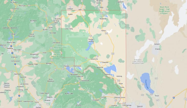
Cities and Towns in Lassen County, California

Founded in 1864, Lassen County is one of 58 counties in the state of California. Historically, Lassen County was formed from Plumas and Shasta, and now defunct Lake County, Nevada. The city of Susanville is the county seat. With FIPS code of 35, Lassen County has a population of 33,159 and area of 4,558 square miles (11,805 km²).

List of all cities in Lassen County, CA alphabetically

City/Town Postal Code Area Code
Bieber, CA 96009 530
California Conservation Cent, CA 96130 530
Clear Creek, CA 96137 530
Doyle, CA 96109 530
Eagle Lake Resort, CA 96130 530
Herlong, CA 96113 530
Janesville, CA 96114 530
Johnstonville, CA 96130 530
Lake Almanor Sports & Spirit, CA 96137 530
Litchfield, CA 96117 530
Little Valley, CA 96056 530
Madeline, CA 96119 530
McArthur, CA 96056 530
Milford, CA 96121 530
Nubieber, CA 96068 530
Patton Village, CA 96113 530
Pittville, CA 96056 530
Ravendale, CA 96123 530
Sierra Army Depot, CA 96113 530
Spaulding, CA 96130 530
Standish, CA 96128 530
Susanville, CA 96127 530
96130 530
Termo, CA 96132 530
Wendel, CA 96136 530
Westwood, CA 96137 530

Major Cities and Towns in Lassen County, California

Susanville

Area, Population, and Geographic Coordinates

  • Area: 8.0 square miles
  • Population: Approximately 15,046 (as of 2020)
  • Zip Codes: 96127, 96130
  • Latitude: 40.4163° N
  • Longitude: 120.6530° W

Location and History

Susanville is the county seat and largest city in Lassen County, located in the northeastern part of California. The city was founded in 1853 by Isaac Roop, who named it after his daughter Susan. Originally a trading post for miners during the California Gold Rush, Susanville grew into a lumber town due to the abundant forests in the surrounding area. The city’s location at the head of Honey Lake Valley made it a key supply center for the region. Over the years, Susanville has developed into a hub for government services, with the construction of several state prisons in the area significantly impacting the local economy. The city’s history is deeply tied to both its natural resources and its role as a center of administration and services for Lassen County.

Major Schools and Landmarks

Susanville is served by the Lassen Union High School District and the Susanville Elementary School District, with Lassen High School and Diamond View Middle School being the primary educational institutions. Major landmarks in Susanville include the Lassen Historical Museum, which showcases the city’s history and heritage, and Roop’s Fort, one of the oldest buildings in the area, dating back to the 1850s. The nearby Bizz Johnson Trail offers hiking and biking along a scenic former railroad line that follows the Susan River, while the Lassen National Forest provides opportunities for outdoor activities such as camping, fishing, and exploring the beautiful landscapes of the region. Susanville’s combination of historical significance, educational institutions, and natural beauty make it the central city in Lassen County.

Westwood

Area, Population, and Geographic Coordinates

  • Area: 5.5 square miles
  • Population: Approximately 1,541 (as of 2020)
  • Zip Codes: 96137
  • Latitude: 40.3094° N
  • Longitude: 121.0058° W

Location and History

Westwood is a small town located in the northern part of Lassen County, near Lake Almanor. The town was founded in 1913 by the Red River Lumber Company as a company town for its logging operations. Westwood quickly grew into one of the largest lumber-producing towns in California, with the company’s sawmill being one of the most advanced of its time. The town was known for its well-planned layout, with housing, schools, and amenities provided for the workers and their families. However, as the timber industry declined in the mid-20th century, Westwood’s population and economic significance diminished. Today, Westwood is a quiet, rural community that retains much of its historical character, surrounded by the natural beauty of the Lassen National Forest.

Major Schools and Landmarks

Westwood is served by the Westwood Unified School District, with Westwood High School and Fletcher Walker Elementary School being the primary educational institutions. Major landmarks in Westwood include the Paul Bunyan statue, a nod to the town’s logging heritage, and the Westwood Museum, which preserves the history of the town and the Red River Lumber Company. The nearby Lake Almanor offers opportunities for boating, fishing, and camping, attracting visitors from across the region. The Lassen Volcanic National Park, located to the south, provides additional recreational opportunities with its volcanic landscapes and geothermal features. Westwood’s combination of historical significance, educational institutions, and access to natural attractions makes it an important community in Lassen County.

Herlong

Area, Population, and Geographic Coordinates

  • Area: 2.9 square miles
  • Population: Approximately 298 (as of 2020)
  • Zip Codes: 96113
  • Latitude: 40.1485° N
  • Longitude: 120.1436° W

Location and History

Herlong is a small, unincorporated community located in the southeastern part of Lassen County, near the Nevada border. The town was established in 1942 as a support community for the Sierra Army Depot, a U.S. Army facility used for munitions storage and supply. Named after Captain Henry W. Herlong, the town developed rapidly during World War II, providing housing and services for the military personnel and civilian workers at the depot. After the war, Herlong’s population declined as the demand for military supplies decreased, but the Sierra Army Depot remains an important economic factor in the community. Herlong’s history is closely tied to the military, and the town continues to serve as a residential area for those associated with the depot.

Major Schools and Landmarks

Herlong is served by the Fort Sage Unified School District, with Herlong High School and Sierra Primary School being the primary educational institutions. Major landmarks in Herlong include the Sierra Army Depot, which is the largest employer in the area and plays a central role in the community’s economy. The nearby Honey Lake offers opportunities for birdwatching and exploring the local wildlife, while the surrounding desert and mountain landscapes provide a unique setting for outdoor activities. Herlong’s combination of military significance, educational institutions, and rural charm make it an important part of Lassen County.

Janesville

Area, Population, and Geographic Coordinates

  • Area: 13.2 square miles
  • Population: Approximately 1,408 (as of 2020)
  • Zip Codes: 96114
  • Latitude: 40.2938° N
  • Longitude: 120.5455° W

Location and History

Janesville is a small, unincorporated community located in the Honey Lake Valley, southeast of Susanville. The town was founded in the mid-19th century and named after Jane Bankhead, the wife of one of the area’s early settlers. Janesville developed as a farming and ranching community, with its economy based on agriculture and livestock. The town’s location along the old Lassen Emigrant Trail made it an important stop for travelers heading west during the California Gold Rush. Today, Janesville remains a rural community with a strong connection to its agricultural roots, offering a peaceful lifestyle surrounded by the natural beauty of the Lassen National Forest.

Major Schools and Landmarks

Janesville is served by the Janesville Union Elementary School District, with Janesville Elementary School being the primary educational institution. Major landmarks in Janesville include the Janesville Historic Cemetery, which reflects the town’s early history and the lives of its pioneer settlers. The nearby Thompson Peak offers hiking and outdoor recreation opportunities, with panoramic views of the Honey Lake Valley and the surrounding mountains. The Lassen National Forest, which borders the community, provides access to vast wilderness areas for camping, fishing, and exploring the natural landscape. Janesville’s combination of historical significance, educational institutions, and rural charm makes it an important community in Lassen County.

Map of Cities in Lassen County, CA

Map of Cities in Lassen County, CA