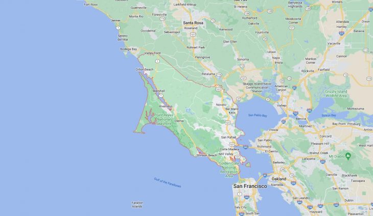
Cities and Towns in Marin County, California
Founded in 1850, Marin County is one of 58 counties in the state of California. The city of San Rafael is the county seat. With FIPS code of 41, Marin County has a population of 260,206 and area of 520 square miles (1,347 km²).
List of all cities in Marin County, CA alphabetically
City/Town | Postal Code | Area Code |
Bel Marin Keyes, CA | 94949 | 415 |
Bel Tiburon, CA | 94920 | 415 |
Belvedere, CA | 94920 | 415 |
Belvedere Tiburon, CA | 94920 | 415 |
Black Point, CA | 94945 | 415 |
Bolinas, CA | 94924 | 415 |
Corte Madera, CA | 94925 | 415 |
94976 | 415 | |
Dillon Beach, CA | 94929 | 707 |
Fairfax, CA | 94930 | 415 |
94978 | 415 | |
Firemans Fund Ins, CA | 94998 | 415 |
Forest Knolls, CA | 94933 | 415 |
Greenbrae, CA | 94904 | 415 |
94914 | 415 | |
Ignacio, CA | 94949 | 415 |
Inverness, CA | 94937 | 415 |
Kent Woodlands, CA | 94904 | 415 |
Kentfield, CA | 94904 | 415 |
94914 | 415 | |
Lagunitas, CA | 94938 | 415 |
Larkspur, CA | 94939 | 415 |
94977 | 415 | |
Marin City, CA | 94965 | 415 |
Marinwood, CA | 94903 | 415 |
Marshall, CA | 94940 | 415 |
Mill Valley, CA | 94941 | 415 |
94942 | 415 | |
Mission Rafael, CA | 94915 | 415 |
Muir Beach, CA | 94965 | 415 |
Muir Woods, CA | 94941 | 415 |
Nicasio, CA | 94946 | 415 |
Novato, CA | 94945 | 415 |
94947 | 415 | |
94948 | 415 | |
94949 | 415 | |
94998 | 415 | |
Olema, CA | 94950 | 415 |
Point Reyes Station, CA | 94956 | 415 |
Ross, CA | 94957 | 415 |
San Anselmo, CA | 94960 | 415 |
94979 | 415 | |
San Geronimo, CA | 94963 | 415 |
San Marin, CA | 94945 | 415 |
San Quentin, CA | 94964 | 415 |
94974 | 415 | |
San Rafael, CA | 94901 | 415 |
94903 | 415 | |
94904 | 415 | |
94912 | 415 | |
94913 | 415 | |
94914 | 415 | |
94915 | 415 | |
Santa Venetia, CA | 94903 | 415 |
Sausalito, CA | 94965 | 415 |
94966 | 415 | |
Stinson Beach, CA | 94970 | 415 |
Strawberry Point, CA | 94941 | 415 |
Tamalpais Valley, CA | 94941 | 415 |
Terra Linda, CA | 94903 | 415 |
Tiburon, CA | 94920 | 415 |
Tomales, CA | 94971 | 707 |
Woodacre, CA | 94973 | 415 |
Major Cities and Towns in Marin County, California
San Rafael
Area, Population, and Geographic Coordinates
- Area: 22.4 square miles
- Population: Approximately 61,271 (as of 2020)
- Zip Codes: 94901, 94903
- Latitude: 37.9735° N
- Longitude: 122.5311° W
Location and History
San Rafael is the county seat and largest city in Marin County, located in the North Bay region of the San Francisco Bay Area. The city was founded in 1817 as the site of Mission San Rafael Arcángel, the 20th of the California missions. San Rafael played a crucial role in the early development of Marin County, serving as a center for agriculture and trade. Over time, the city grew into a key administrative and commercial hub for the county. San Rafael’s historic downtown area features a mix of preserved Victorian buildings and modern developments, reflecting its rich history and ongoing growth. The city is known for its diverse community, vibrant arts scene, and access to outdoor recreation in the nearby hills and waterfront areas.
Major Schools and Landmarks
San Rafael is served by the San Rafael City Schools district, with notable schools including San Rafael High School and Terra Linda High School. Dominican University of California, a private institution known for its strong liberal arts programs, is also located in the city. Major landmarks in San Rafael include the Marin County Civic Center, designed by renowned architect Frank Lloyd Wright, which is both a functional government building and a celebrated example of modernist architecture. The Mission San Rafael Arcángel, a replica of the original mission, serves as a historical site and active parish. The city’s proximity to Mount Tamalpais and the Marin Headlands provides ample opportunities for hiking, biking, and exploring the natural beauty of Marin County.
Mill Valley
Area, Population, and Geographic Coordinates
- Area: 4.8 square miles
- Population: Approximately 14,231 (as of 2020)
- Zip Codes: 94941, 94942
- Latitude: 37.9060° N
- Longitude: 122.5446° W
Location and History
Mill Valley is a picturesque town located at the base of Mount Tamalpais, just north of the Golden Gate Bridge. The town was originally founded in the late 19th century as a logging community, with its name derived from the sawmills that processed timber from the surrounding redwood forests. Mill Valley quickly became a popular retreat for San Franciscans seeking a rural escape from the city. The town’s development was influenced by its natural surroundings, with many of its neighborhoods nestled in the hills and among the trees. Over the years, Mill Valley has grown into a desirable residential community known for its scenic beauty, artistic culture, and strong sense of community.
Major Schools and Landmarks
Mill Valley is served by the Mill Valley School District, with notable schools including Tamalpais High School and Mill Valley Middle School. Major landmarks in Mill Valley include the Muir Woods National Monument, a protected area of old-growth coastal redwoods that attracts visitors from around the world, and the Mill Valley Film Festival, an internationally recognized event that showcases independent and international films. The Marin Theatre Company, located in Mill Valley, is a leading regional theater that offers a range of performances and educational programs. The town’s location near Mount Tamalpais State Park provides residents and visitors with access to extensive hiking trails, panoramic views, and a variety of outdoor activities.
Novato
Area, Population, and Geographic Coordinates
- Area: 27.4 square miles
- Population: Approximately 53,225 (as of 2020)
- Zip Codes: 94945, 94947, 94948, 94949, 94998
- Latitude: 38.1074° N
- Longitude: 122.5697° W
Location and History
Novato is the northernmost city in Marin County, located along U.S. Route 101. The area was originally inhabited by the Coast Miwok people before becoming part of a Mexican land grant in the early 19th century. Novato was officially incorporated as a city in 1960, though its roots as a farming community date back to the mid-1800s. The city has experienced significant growth since its incorporation, evolving from a rural town into a suburban community with a mix of residential, commercial, and industrial areas. Novato is known for its blend of historic charm and modern amenities, with a strong focus on preserving open space and natural beauty.
Major Schools and Landmarks
Novato is served by the Novato Unified School District, with notable schools including Novato High School and San Marin High School. The city is also home to the College of Marin’s Indian Valley Campus, which offers a range of academic programs and continuing education opportunities. Major landmarks in Novato include the Marin Museum of Contemporary Art, which features rotating exhibitions of modern and contemporary art, and the Hamilton Field History Museum, which preserves the history of the former Hamilton Air Force Base. The nearby Olompali State Historic Park offers hiking trails, picnic areas, and a glimpse into the region’s Native American and early settler history. Novato’s combination of historical significance, educational institutions, and suburban appeal makes it a key city in Marin County.
Sausalito
Area, Population, and Geographic Coordinates
- Area: 2.2 square miles
- Population: Approximately 7,116 (as of 2020)
- Zip Codes: 94965, 94966
- Latitude: 37.8591° N
- Longitude: 122.4853° W
Location and History
Sausalito is a scenic waterfront town located just north of the Golden Gate Bridge, along the San Francisco Bay. The town was originally developed as a ferry terminal and shipbuilding center during the 19th century. Sausalito’s name, derived from the Spanish word for “little willow,” reflects the willows that once lined its creeks. The town’s history is closely tied to its maritime roots, with shipyards playing a crucial role during World War II. After the war, Sausalito transformed into a bohemian enclave, attracting artists, writers, and musicians. Today, Sausalito is known for its picturesque waterfront, houseboat communities, and stunning views of the San Francisco skyline.
Major Schools and Landmarks
Sausalito is served by the Sausalito Marin City School District, with Willow Creek Academy being a notable school in the area. Major landmarks in Sausalito include the Bay Area Discovery Museum, a hands-on children’s museum located at Fort Baker, and the historic Sausalito Yacht Harbor, which is home to a vibrant boating community. The town’s scenic waterfront is lined with galleries, shops, and restaurants, making it a popular destination for tourists. The Marin Headlands, part of the Golden Gate National Recreation Area, offers hiking trails, wildlife viewing, and panoramic views of the Golden Gate Bridge. Sausalito’s combination of maritime history, educational institutions, and stunning natural beauty makes it a unique and desirable community in Marin County.
Larkspur
Area, Population, and Geographic Coordinates
- Area: 3.05 square miles
- Population: Approximately 12,254 (as of 2020)
- Zip Codes: 94939, 94977
- Latitude: 37.9341° N
- Longitude: 122.5353° W
Location and History
Larkspur is a charming town located in the central part of Marin County, nestled between Mount Tamalpais and the San Francisco Bay. The town was founded in the late 19th century and named after the larkspur wildflowers that bloom in the area. Larkspur developed as a residential community with a focus on preserving its natural beauty and small-town character. The town’s historic downtown area, known as Larkspur Landing, features well-preserved Victorian buildings and has been designated as a National Historic District. Larkspur’s location near major transportation routes has made it a desirable place to live for those commuting to San Francisco and other parts of the Bay Area.
Major Schools and Landmarks
Larkspur is served by the Larkspur-Corte Madera School District, with Redwood High School and Hall Middle School being the primary educational institutions. Major landmarks in Larkspur include the Lark Theater, a historic movie theater that hosts films and cultural events, and the Golden Gate Ferry terminal at Larkspur Landing, which provides ferry service to San Francisco. The town’s proximity to the Corte Madera Creek and the surrounding open spaces offers opportunities for outdoor activities such as hiking, biking, and kayaking. The Marin Country Mart, a popular shopping and dining destination, is also located in Larkspur, reflecting the town’s blend of history and modern amenities. Larkspur’s combination of historic charm, educational institutions, and convenient location makes it an important community in Marin County.