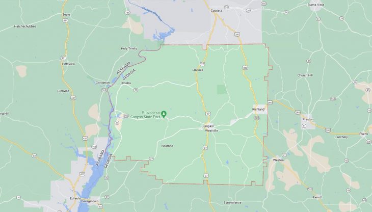
Cities and Towns in Stewart County, Georgia
Founded in 1830, Stewart County is one of 159 counties in the state of Georgia. Historically, Stewart County was formed from Randolph County. The city of Lumpkin is the county seat. With FIPS code of 259, Stewart County has a population of 5,341 and area of 459 square miles (1,189 km²).
List of all cities in Stewart County, GA alphabetically
City/Town | Postal Code | Area Code |
Louvale, GA | 31814 | 229 |
Lumpkin, GA | 31815 | 229 |
Omaha, GA | 31821 | 229 |
Richland, GA | 31825 | 229 |
Major Cities and Towns in Stewart County, Georgia
Lumpkin
Overview
Lumpkin, the county seat of Stewart County, is a city with a rich historical legacy and Southern charm. Established in 1828, Lumpkin was named after Wilson Lumpkin, a prominent Georgia politician and governor. The city played a significant role in the antebellum South, serving as a center for cotton trade and agriculture. During the 19th century, Lumpkin was a thriving town, benefiting from its strategic location on trade routes and its fertile farmland. The city’s historic district is filled with well-preserved antebellum homes and buildings, reflecting its past prosperity. Today, Lumpkin is a quiet, small town that retains much of its historical character, offering visitors a glimpse into Georgia’s past.
Key Information
- Area: Approximately 1.6 square miles
- Population: Around 1,000 (latest census)
- Zip Codes: 31815
- Latitude: 32.0502° N
- Longitude: 84.7961° W
Schools and Landmarks
Lumpkin is served by the Stewart County School District, with Stewart County High School and Stewart County Elementary School providing education to the local youth. The city is home to several significant landmarks, including the Bedingfield Inn, a historic structure dating back to the 1830s, which now operates as a museum. Another key landmark is Providence Canyon State Park, often referred to as “Georgia’s Little Grand Canyon,” located just a few miles outside the city. The park is known for its stunning canyons and vibrant colors, attracting nature enthusiasts and tourists alike. The annual Lumpkin Magnolia Festival celebrates the city’s history and Southern heritage, bringing together residents and visitors for a weekend of festivities.
Richland
Overview
Richland is a small city in Stewart County, known for its rich agricultural history and historic downtown area. The city was established in the mid-19th century and quickly grew as a result of the railroad, which brought new opportunities for trade and commerce. Richland’s economy has traditionally been based on agriculture, with cotton and peanuts being the primary crops. The city’s downtown area is characterized by its historic buildings, many of which date back to the late 19th and early 20th centuries, reflecting its prosperous past. Today, Richland is a peaceful community that values its history and offers a quiet, rural lifestyle.
Key Information
- Area: Approximately 3.3 square miles
- Population: Around 1,400 (latest census)
- Zip Codes: 31825
- Latitude: 32.0868° N
- Longitude: 84.6671° W
Schools and Landmarks
Richland is served by the Stewart County School District, with students typically attending schools in nearby Lumpkin. The city is home to several notable landmarks, including the historic Richland Depot, which has been preserved as a reminder of the city’s railroad heritage. The downtown area also features several historic storefronts and homes that add to the city’s charm. Richland Rum Distillery, a local business that has gained national recognition, produces hand-crafted rum and offers tours and tastings, drawing visitors from across the region. The city’s close proximity to Providence Canyon State Park makes it a popular stop for tourists exploring the natural beauty of southwest Georgia.
Omaha
Overview
Omaha is a small, unincorporated community in Stewart County, located near the Alabama state line. The community was established in the late 19th century as a rural farming settlement. Omaha’s history is closely tied to agriculture, with farming being the primary economic activity since its founding. The community’s location near the Chattahoochee River has also contributed to its development, providing access to water resources and transportation routes. Although small, Omaha has maintained its rural charm and close-knit community atmosphere, making it a peaceful place for those who value a quiet, country lifestyle.
Key Information
- Area: Approximately 1.2 square miles
- Population: Around 125 (latest estimate)
- Zip Codes: 31821
- Latitude: 32.0904° N
- Longitude: 85.0152° W
Schools and Landmarks
Omaha does not have its own schools, with students attending schools in nearby towns such as Lumpkin. The community is known for its rural landscapes and historical landmarks, including several historic churches that have served the area for over a century. The nearby Chattahoochee River offers opportunities for outdoor activities such as fishing and boating, making it a significant natural landmark for the area. Omaha’s small size and rural charm make it a tranquil retreat from the busier pace of life in larger towns and cities, offering a close connection to nature and the agricultural heritage of the region.