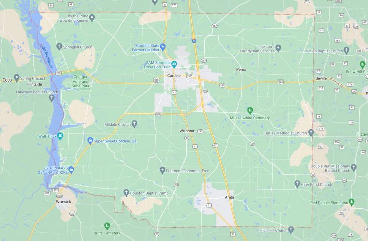
Cities and Towns in Crisp County, Georgia

Founded in 1905, Crisp County is one of 159 counties in the state of Georgia. Historically, Crisp County was formed from Dooly County. The city of Cordele is the county seat. With FIPS code of 81, Crisp County has a population of 19,879 and area of 274 square miles (710 km²).

List of all cities in Crisp County, GA alphabetically

City/Town Postal Code Area Code
Arabi, GA 31712 229
Cordele, GA 31010 229
31015 229

Major Cities and Towns in Crisp County, Georgia

Cordele

Area, Population, Zip Codes, and Coordinates

  • Area: 10.2 square miles
  • Population: Approximately 11,000
  • Zip Codes: 31015, 31010
  • Latitude: 31.9635° N
  • Longitude: 83.7730° W

City Location and History

Cordele, the county seat of Crisp County, is located in south-central Georgia, approximately halfway between Macon and Albany. The city was founded in 1888 and named after Cordelia Hawkins, the daughter of the president of the Savannah, Americus, and Montgomery Railroad. Cordele quickly became known as the “Hub City” due to its location at the intersection of major railroad lines. The city played a significant role during the early 20th century as a center for the cotton industry. Cordele’s historical significance is also highlighted by its proximity to the site where President Jefferson Davis was captured at the end of the Civil War. Today, Cordele continues to be a vibrant community, known for its historic charm and as the “Watermelon Capital of the World.”

Major Schools and Landmarks

Cordele is served by the Crisp County School District, with Crisp County High School being the main educational institution. The city is also home to South Georgia Technical College’s satellite campus. Notable landmarks in Cordele include the SAM Shortline Excursion Train, which offers scenic rides through southwest Georgia, and the historic Cordele Railway Museum. The Georgia Veterans State Park, located on the shores of Lake Blackshear, offers recreational activities such as boating, fishing, and golfing. The park also houses the Georgia Veterans Memorial, honoring those who served in the U.S. military. Cordele’s blend of history, education, and outdoor activities makes it a key community within Crisp County.

Arabi

Area, Population, Zip Codes, and Coordinates

  • Area: 1.2 square miles
  • Population: Approximately 600
  • Zip Codes: 31712
  • Latitude: 31.8318° N
  • Longitude: 83.7321° W

City Location and History

Arabi is a small town located in the southern part of Crisp County, Georgia. The town was incorporated in 1891 and developed primarily as an agricultural community. Named after the Arabian horse, Arabi’s early economy was centered around farming, with cotton and peanuts being the primary crops. The town’s growth was further spurred by the arrival of the railroad, which provided a vital transportation link for local farmers. Despite its small size, Arabi has maintained a strong sense of community and rural charm. The town’s history is reflected in its well-preserved buildings and the strong agricultural presence that remains to this day.

Major Schools and Landmarks

Arabi is served by the Crisp County School District, with students attending schools in nearby Cordele. The town’s landmarks include several historic churches and buildings that reflect its late 19th-century origins. Arabi is also known for its proximity to natural attractions such as the Flint River, which offers opportunities for fishing, boating, and other outdoor activities. The town’s annual events, such as the Arabi Peanut Festival, celebrate its agricultural heritage and draw visitors from across the region. Arabi’s small-town charm and close-knit community make it a peaceful place to live within Crisp County.

Warwick (Partly in Crisp County)

Area, Population, Zip Codes, and Coordinates

  • Area: 1.7 square miles (portion in Crisp County)
  • Population: Approximately 430 (entire town)
  • Zip Codes: 31796
  • Latitude: 31.8310° N
  • Longitude: 83.9191° W

City Location and History

Warwick is a small town that straddles the border between Crisp and Worth counties in Georgia. The town was incorporated in 1905 and named after the Earl of Warwick, reflecting the influence of British settlers in the region. Warwick developed as a rural farming community, with its economy historically based on agriculture, particularly the cultivation of cotton and peanuts. The town’s location along the Flint River provided essential water resources for farming and contributed to its growth. Today, Warwick remains a small, rural community with a rich agricultural heritage and a strong connection to the surrounding natural environment.

Major Schools and Landmarks

The portion of Warwick within Crisp County is served by the Crisp County School District, while the remainder is served by the Worth County School District. Key landmarks in Warwick include the historic Warwick Methodist Church and the Warwick City Hall, both of which reflect the town’s long-standing community values. The nearby Lake Blackshear offers recreational opportunities for fishing, boating, and outdoor activities, making it a popular destination for residents and visitors alike. Warwick’s rural charm, historical significance, and natural beauty make it a unique and appealing place to live within Crisp County.

Map of Cities in Crisp County, GA

Map of Cities in Crisp County, GA