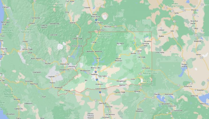
Cities and Towns in Shasta County, California

Founded in 1850, Shasta County is one of 58 counties in the state of California. The city of Redding is the county seat. With FIPS code of 89, Shasta County has a population of 182,139 and area of 3,786 square miles (9,806 km²).

List of all cities in Shasta County, CA alphabetically

City/Town Postal Code Area Code
Anderson, CA 96007 530
Bella Vista, CA 96008 530
Big Bend, CA 96011 530
Burney, CA 96013 530
Cassel, CA 96016 530
Castella, CA 96017 530
Central Valley, CA 96019 530
96079 530
Cottonwood, CA 96022 530
Fall River Mills, CA 96028 530
Fl River Mls, CA 96028 530
French Gulch, CA 96033 530
Hat Creek, CA 96040 530
Igo, CA 96047 530
Johnson Park, CA 96013 530
Keswick, CA 96001 530
Lakehead, CA 96051 530
96070 530
Millville, CA 96062 530
Montgomery Creek, CA 96065 530
Oak Run, CA 96069 530
Obrien, CA 96070 530
Old Station, CA 96071 530
Olinda, CA 96007 530
Palo Cedro, CA 96073 530
Platina, CA 96076 530
Project City, CA 96079 530
Redding, CA 96001 530
96002 530
96003 530
96049 530
96099 530
Round Mountain, CA 96084 530
Shasta, CA 96087 530
Shasta Lake, CA 96019 530
96079 530
96089 530
Shingletown, CA 96088 530
Summit City, CA 96089 530
Sweet Brier, CA 96017 530
Viola, CA 96088 530
Whiskeytown, CA 96095 530
Whitmore, CA 96096 530
Wildwood, CA 96076 530

Major Cities and Towns in Shasta County, California

Redding

Area, Population, and Geography

  • Area: 61.2 square miles
  • Population: Approximately 94,000 (2023 estimate)
  • Zip Codes: 96001-96003, 96049, 96099
  • Latitude: 40.5865° N
  • Longitude: 122.3917° W

City Location and History

Redding, the county seat of Shasta County, is located in Northern California, along the Sacramento River, about 160 miles north of Sacramento. Originally established as a railroad town in the late 19th century, Redding was initially called “Reading” after Pierson B. Reading, a land grant recipient. However, the name was later changed to “Redding” after Benjamin B. Redding, a railroad land agent. The city grew rapidly due to its strategic location along the railroad and its proximity to gold mining and timber resources. By the early 20th century, Redding had become a key commercial and transportation hub in Northern California. Today, Redding is known for its stunning natural surroundings, including the nearby Shasta-Trinity National Forest and Shasta Lake, making it a popular destination for outdoor enthusiasts.

Major Schools and Landmarks

Redding is served by several school districts, with notable institutions including Shasta High School, Enterprise High School, and University Preparatory School. The city is home to significant landmarks such as the Sundial Bridge, a striking pedestrian bridge designed by architect Santiago Calatrava, which spans the Sacramento River and serves as a gateway to the Turtle Bay Exploration Park. The park includes a museum, arboretum, and botanical gardens, offering cultural and educational experiences. Another key landmark is the historic Cascade Theatre, a beautifully restored Art Deco venue that hosts a variety of performances. Additionally, Redding’s proximity to natural attractions like Lassen Volcanic National Park and Whiskeytown Lake makes it a hub for adventure tourism, with opportunities for hiking, boating, and fishing.

Anderson

Area, Population, and Geography

  • Area: 6.6 square miles
  • Population: Approximately 11,000 (2023 estimate)
  • Zip Codes: 96007
  • Latitude: 40.4485° N
  • Longitude: 122.2973° W

City Location and History

Anderson is located in the southern part of Shasta County, approximately 10 miles south of Redding along Interstate 5. The city was established in the late 19th century, named after Elias Anderson, a prominent early settler and rancher in the area. Anderson quickly developed as an agricultural and logging center, benefiting from its location along the railroad and the Sacramento River. The town’s economy was historically driven by these industries, with sawmills and farms playing a significant role in its growth. Over time, Anderson evolved from a small agricultural community into a more suburban environment, although it still retains much of its small-town charm and connection to its rural roots.

Major Schools and Landmarks

Anderson is served by the Anderson Union High School District, with Anderson High School and Anderson New Technology High School being the primary secondary institutions. Notable landmarks in Anderson include the Anderson River Park, a large recreational area that offers walking trails, picnic areas, and access to the Sacramento River. The city also hosts the annual Anderson Explodes Fourth of July celebration, which is a significant community event featuring fireworks, music, and family-friendly activities. Another landmark is the historic Anderson Log Cabin, a preserved structure that provides a glimpse into the town’s pioneer past. Anderson’s blend of history, community spirit, and natural beauty makes it a welcoming and vibrant place to live.

Shasta Lake

Area, Population, and Geography

  • Area: 11.1 square miles
  • Population: Approximately 10,500 (2023 estimate)
  • Zip Codes: 96019
  • Latitude: 40.6807° N
  • Longitude: 122.3706° W

City Location and History

Shasta Lake, located just north of Redding, is a city that was incorporated in 1993, named after the nearby Shasta Lake reservoir, the largest man-made lake in California. The city was originally developed during the construction of Shasta Dam in the 1930s and 1940s, which was part of the Central Valley Project, a major water management initiative. The dam’s construction attracted workers and their families, leading to the establishment of several communities that eventually merged to form the city of Shasta Lake. Today, the city is known for its close connection to outdoor recreation, with the lake and surrounding Shasta-Trinity National Forest offering abundant opportunities for boating, fishing, camping, and hiking.

Major Schools and Landmarks

Shasta Lake is served by the Gateway Unified School District, with Central Valley High School being the primary secondary school. Major landmarks in the city include Shasta Dam, one of the tallest dams in the United States, which offers tours and stunning views of the lake and surrounding mountains. The lake itself is a major draw for tourists and locals alike, providing a wide range of water activities and scenic spots. Another notable site is the Chappie-Shasta Off-Highway Vehicle (OHV) Area, which is popular with off-road enthusiasts. The city’s proximity to Redding and the natural attractions of the Shasta-Trinity region make Shasta Lake a unique community with a strong focus on outdoor living.

Burney

Area, Population, and Geography

  • Area: 5.1 square miles
  • Population: Approximately 3,000 (2023 estimate)
  • Zip Codes: 96013
  • Latitude: 40.8821° N
  • Longitude: 121.6647° W

City Location and History

Burney is a small town located in the northeastern part of Shasta County, nestled in the mountains near the McArthur-Burney Falls Memorial State Park. The town was named after Samuel Burney, a pioneer settler who arrived in the area in the 1850s. Burney developed as a logging and milling town, with the timber industry playing a central role in its economy for much of the 20th century. The town’s location, surrounded by forests and close to the Pit River, made it an ideal spot for the timber industry, and it also became a gateway for visitors to the natural attractions of the region. Today, Burney is known for its stunning natural scenery and outdoor recreational opportunities.

Major Schools and Landmarks

Burney is served by the Fall River Joint Unified School District, with Burney Junior-Senior High School being the main educational institution. The town is best known for its proximity to Burney Falls, a stunning 129-foot waterfall located in the McArthur-Burney Falls Memorial State Park. This park is a major landmark and a popular destination for hiking, fishing, and camping. Other notable sites include the Burney Mountain, which offers panoramic views of the surrounding region, and the nearby Lassen Volcanic National Park. Burney’s rich natural environment and small-town charm make it a peaceful retreat for both residents and visitors.

Shingletown

Area, Population, and Geography

  • Area: 23.7 square miles
  • Population: Approximately 2,500 (2023 estimate)
  • Zip Codes: 96088
  • Latitude: 40.4924° N
  • Longitude: 121.8886° W

City Location and History

Shingletown is a small, rural community located in the southern part of Shasta County, along Highway 44, east of Redding. The town was originally established in the 19th century as a logging and shingle-making community, hence its name. Shingletown served as a hub for the local timber industry, with numerous mills operating in the surrounding forests. Over time, as the logging industry declined, Shingletown evolved into a quiet, residential community, known for its scenic beauty and proximity to Lassen Volcanic National Park. The town’s location in the foothills of the Cascade Range, with easy access to both the Sacramento Valley and the high country, has made it a popular spot for those seeking a rural lifestyle with access to outdoor recreation.

Major Schools and Landmarks

Shingletown is served by the Black Butte Union Elementary School District, with Black Butte Elementary School being the primary educational institution. The town’s most notable landmarks are its natural surroundings, particularly the nearby Lassen Volcanic National Park, which offers a variety of outdoor activities, including hiking, camping, and exploring geothermal features. The park’s proximity makes Shingletown a gateway for visitors looking to explore the volcanic landscapes and alpine meadows of the region. Other local attractions include the Shingletown Ridge and the Battle Creek Reservoir, which are popular for fishing, boating, and hiking. Shingletown’s tranquil setting and access to nature make it an ideal community for those who appreciate the outdoors and a slower pace of life.

Map of Cities in Shasta County, CA

Map of Cities in Shasta County, CA