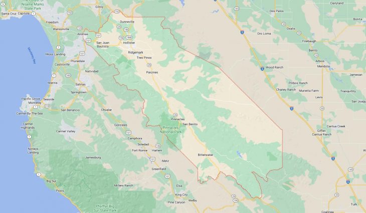
Cities and Towns in San Benito County, California

Founded in 1874, San Benito County is one of 58 counties in the state of California. Historically, San Benito County was formed from Monterey. The city of Hollister is the county seat. With FIPS code of 69, San Benito County has a population of 66,677 and area of 1,389 square miles (3,597 km²).

List of all cities in San Benito County, CA alphabetically

City/Town Postal Code Area Code
Hollister, CA 95023 831
Hollister, CA 95024 831
New Idria, CA 95043 831
Paicines, CA 95043 831
Panoche, CA 95043 831
Pinnacles, CA 95043 831
San Benito, CA 95043 831
San Juan Bautista, CA 95045 831
Tres Pinos, CA 95075 831

Major Cities and Towns in San Benito County, California

Hollister

Area, Population, and Geography

  • Area: 7.3 square miles
  • Population: Approximately 41,000 (2023 estimate)
  • Zip Codes: 95023, 95024
  • Latitude: 36.8525° N
  • Longitude: 121.4016° W

City Location and History

Hollister, the county seat of San Benito County, is located in the central part of California, about 95 miles southeast of San Francisco. The city was founded in 1868 as part of the Rancho San Justo land grant and was named after William Welles Hollister, a wealthy sheep rancher who played a significant role in the development of the area. Hollister grew as an agricultural hub, benefiting from its fertile soil and ideal climate for crops like grapes, apricots, and walnuts. Over time, the city developed a reputation for its rural charm and community-oriented atmosphere. Hollister is perhaps most famous for its connection to the 1947 motorcycle rally that inspired the 1953 film “The Wild One,” starring Marlon Brando, which cemented its association with motorcycle culture.

Major Schools and Landmarks

Hollister is served by the Hollister School District and the San Benito High School District, with San Benito High School being the primary secondary institution. The city’s major landmarks include the historic San Benito County Courthouse, which reflects the city’s long-standing role as the administrative center of the county. Another key site is the Veterans Memorial Building, which hosts various community events and serves as a gathering place for local organizations. Hollister’s downtown area features a mix of shops, restaurants, and historic buildings, offering a glimpse into the city’s past while catering to modern needs. The nearby Pinnacles National Park, known for its unique rock formations and diverse wildlife, is a popular destination for hiking, rock climbing, and exploring nature, adding to Hollister’s appeal as a gateway to outdoor adventure.

San Juan Bautista

Area, Population, and Geography

  • Area: 0.7 square miles
  • Population: Approximately 2,000 (2023 estimate)
  • Zip Codes: 95045
  • Latitude: 36.8452° N
  • Longitude: 121.5383° W

City Location and History

San Juan Bautista is located in the northern part of San Benito County, near the border with Monterey County. The city is centered around Mission San Juan Bautista, founded in 1797 as the 15th of the 21 California missions. The mission, named after Saint John the Baptist, played a critical role in the early development of the region, serving as a religious and cultural hub for the surrounding area. The town grew around the mission, with its strategic location along the El Camino Real (The Royal Road) contributing to its importance as a stopover for travelers. San Juan Bautista has retained much of its historic charm, with numerous preserved buildings and a strong connection to its Spanish and Mexican heritage.

Major Schools and Landmarks

San Juan Bautista is served by the Aromas-San Juan Unified School District, with San Juan School providing education for younger students, while high school students typically attend Anzar High School in nearby San Juan Valley. The city’s most prominent landmark is Mission San Juan Bautista, which remains an active parish and a popular tourist destination. The mission complex includes the original church, a museum, and beautifully landscaped gardens. The surrounding San Juan Bautista State Historic Park preserves many historic structures from the 19th century, offering visitors a glimpse into California’s past. The town also hosts various cultural events, including the annual San Juan Bautista Arts & Crafts Festival and the traditional Mexican fiesta, El Día de San Juan. San Juan Bautista’s rich history, cultural significance, and picturesque setting make it a unique and treasured community in San Benito County.

Tres Pinos

Area, Population, and Geography

  • Area: 0.3 square miles
  • Population: Approximately 500 (2023 estimate)
  • Zip Codes: 95075
  • Latitude: 36.7872° N
  • Longitude: 121.3178° W

City Location and History

Tres Pinos is a small, unincorporated community located about six miles south of Hollister, in the southern part of San Benito County. The town was established in the late 19th century as a railroad stop on the Southern Pacific Railroad, which played a crucial role in transporting goods and passengers through the region. Tres Pinos, meaning “Three Pines” in Spanish, was named after three prominent pine trees that served as a landmark for early settlers. The town developed as a quiet agricultural community, with ranching and farming being the primary economic activities. Tres Pinos remains a small, close-knit community with a rich history and a rural character that has been preserved over the years.

Major Schools and Landmarks

Tres Pinos is served by the Tres Pinos Union School District, with Tres Pinos Elementary School being the main educational institution in the area, providing K-8 education. High school students typically attend San Benito High School in nearby Hollister. The town’s major landmarks include the historic Immaculate Conception Church, a small but significant religious site that has been serving the local Catholic community for over a century. Another notable landmark is the 19th Hole Booze & Food, a historic roadhouse that has been a gathering place for locals and visitors alike since the 1930s. Tres Pinos is also known for its proximity to Bolado Park, home to the San Benito County Fair and various rodeo events, reflecting the town’s deep connection to its agricultural and ranching roots. Tres Pinos’ tranquil setting, historical significance, and community spirit make it a unique and charming place in San Benito County.

Aromas

Area, Population, and Geography

  • Area: 4.3 square miles
  • Population: Approximately 2,800 (2023 estimate)
  • Zip Codes: 95004
  • Latitude: 36.8822° N
  • Longitude: 121.6405° W

City Location and History

Aromas is a small, unincorporated community located in the northern part of San Benito County, near the border with Monterey and Santa Cruz counties. The town was originally established in the late 19th century as a stop on the Southern Pacific Railroad. Aromas was named for the fragrant wildflowers and herbs that grew abundantly in the surrounding hills. The community developed as an agricultural area, with farming and ranching being the primary economic activities. Aromas has maintained its rural character and small-town charm over the years, becoming a quiet, close-knit community that attracts those seeking a slower pace of life.

Major Schools and Landmarks

Aromas is served by the Aromas-San Juan Unified School District, with Aromas School providing education for elementary and middle school students. High school students typically attend Anzar High School, located in nearby San Juan Bautista. The town’s major landmarks include the Aromas Community Grange, a historic building that serves as a hub for local events, meetings, and social gatherings. The nearby Aromas Hills offer scenic views, hiking trails, and opportunities for outdoor recreation. Aromas is also known for its annual Aromas Day, a community festival featuring a parade, arts and crafts, live music, and food vendors. The town’s blend of rural beauty, community spirit, and historical significance make Aromas a unique and welcoming place in San Benito County.

Map of Cities in San Benito County, CA

Map of Cities in San Benito County, CA