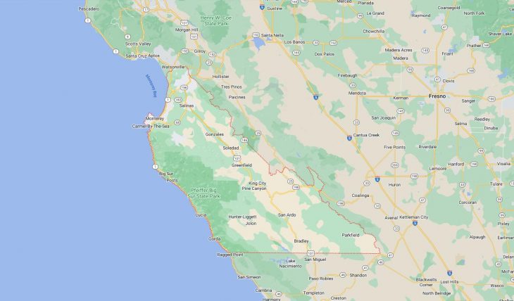
Cities and Towns in Monterey County, California
Founded in 1850, Monterey County is one of 58 counties in the state of California. The city of Salinas is the county seat. With FIPS code of 53, Monterey County has a population of 437,325 and area of 3,322 square miles (8,604 km²).
List of all cities in Monterey County, CA alphabetically
City/Town | Postal Code | Area Code |
Alisal, CA | 93905 | 831 |
Aromas, CA | 95004 | 831 |
Big Sur, CA | 93920 | 831 |
Bradley, CA | 93426 | 805 |
Carmel, CA | 93921 | 831 |
93922 | 831 | |
93923 | 831 | |
Carmel by the Sea, CA | 93921 | 831 |
Carmel Highlands, CA | 93923 | 831 |
Carmel Valley, CA | 93924 | 831 |
Carmel Valley Village, CA | 93924 | 831 |
Castroville, CA | 95012 | 831 |
Chualar, CA | 93925 | 831 |
Corral de Tierra, CA | 93908 | 831 |
Del Monte Park, CA | 93950 | 831 |
Del Rey Oaks, CA | 93940 | 831 |
Fort Hunter Liggett, CA | 93928 | 831 |
Gonzales, CA | 93926 | 831 |
Gorda, CA | 93920 | 831 |
Greenfield, CA | 93927 | 831 |
Jolon, CA | 93928 | 831 |
King City, CA | 93930 | 831 |
Lake Nacimiento, CA | 93426 | 805 |
Lockwood, CA | 93932 | 831 |
Lucia, CA | 93920 | 831 |
Marina, CA | 93933 | 831 |
Monterey, CA | 93940 | 831 |
93942 | 831 | |
93943 | 831 | |
93944 | 831 | |
Moss Landing, CA | 95039 | 831 |
Nacimiento Lake, CA | 93426 | 805 |
Oak Shores, CA | 93426 | 805 |
Pacific Grove, CA | 93950 | 831 |
Pacific Valley, CA | 93920 | 831 |
Pebble Beach, CA | 93953 | 831 |
Point Sur, CA | 93940 | 831 |
Presidio of Monterey, CA | 93940 | 831 |
93944 | 831 | |
Prunedale, CA | 93907 | 831 |
Robles del Rio, CA | 93924 | 831 |
Salinas, CA | 93901 | 831 |
93902 | 831 | |
93905 | 831 | |
93906 | 831 | |
93907 | 831 | |
93908 | 831 | |
93912 | 831 | |
93915 | 831 | |
93962 | 831 | |
San Ardo, CA | 93450 | 831 |
San Lucas, CA | 93954 | 831 |
Sand City, CA | 93955 | 831 |
Seaside, CA | 93955 | 831 |
Soledad, CA | 93960 | 831 |
Spreckels, CA | 93962 | 831 |
Tassajara Hot Springs, CA | 93924 | 831 |
Major Cities and Towns in Monterey County, California
Salinas
Area, Population, and Geographic Coordinates
- Area: 23.2 square miles
- Population: Approximately 163,542 (as of 2020)
- Zip Codes: 93901, 93905, 93906, 93907, 93908
- Latitude: 36.6777° N
- Longitude: 121.6555° W
Location and History
Salinas is the county seat and largest city in Monterey County, located in the central part of California’s Salinas Valley. The city was founded in 1856 and incorporated in 1874, originally serving as a stop on the Southern Pacific Railroad. Salinas quickly developed into an agricultural hub, known for its fertile soil and ideal climate for growing a wide variety of crops, particularly lettuce, earning it the nickname “Salad Bowl of the World.” The city has a rich cultural history and is known as the birthplace of Nobel Prize-winning author John Steinbeck, who based many of his novels on the people and landscapes of the region. Today, Salinas continues to be a major center for agriculture, while also serving as a cultural and economic hub for the surrounding communities.
Major Schools and Landmarks
Salinas is served by the Salinas Union High School District and the Salinas City Elementary School District, with notable schools including Salinas High School and Everett Alvarez High School. Hartnell College, a community college offering a range of academic programs, is also located in the city. Major landmarks in Salinas include the National Steinbeck Center, a museum dedicated to the life and works of John Steinbeck, and the historic Fox Theater, which hosts concerts, films, and live performances. The city’s downtown area features a mix of historic buildings and modern developments, reflecting its rich history and ongoing growth. The nearby Laguna Seca Raceway is a world-renowned motorsports facility that attracts visitors from around the globe. Salinas’ combination of agricultural significance, educational institutions, and cultural attractions makes it the central city in Monterey County.
Monterey
Area, Population, and Geographic Coordinates
- Area: 8.5 square miles
- Population: Approximately 30,218 (as of 2020)
- Zip Codes: 93940, 93943, 93944
- Latitude: 36.6002° N
- Longitude: 121.8947° W
Location and History
Monterey is a historic city located on the Monterey Peninsula, along the central coast of California. The city was founded in 1770 by Spanish explorers and served as the capital of Alta California under both Spanish and Mexican rule. Monterey was also the site of California’s first theater, public library, and public school, making it a cultural and political center during the early days of the state. The city’s historic Cannery Row, once the center of the sardine-packing industry, was immortalized in the works of John Steinbeck and is now a popular tourist destination. Monterey’s rich history, combined with its stunning coastal scenery, has made it a key destination for visitors seeking both cultural experiences and natural beauty.
Major Schools and Landmarks
Monterey is served by the Monterey Peninsula Unified School District, with notable schools including Monterey High School and Colton Middle School. The city is also home to the Naval Postgraduate School and the Defense Language Institute, both of which contribute to its military presence. Major landmarks in Monterey include the Monterey Bay Aquarium, one of the most renowned aquariums in the world, and Fisherman’s Wharf, which offers shopping, dining, and whale-watching tours. The city’s historic district, which includes sites such as the Custom House and Pacific House Museum, offers a glimpse into Monterey’s colonial past. The nearby 17-Mile Drive and the scenic coastal route provide breathtaking views of the Pacific Ocean and the rugged coastline. Monterey’s combination of historical significance, educational institutions, and coastal beauty makes it a key city in Monterey County.
Seaside
Area, Population, and Geographic Coordinates
- Area: 9.2 square miles
- Population: Approximately 33,930 (as of 2020)
- Zip Codes: 93955
- Latitude: 36.6194° N
- Longitude: 121.8447° W
Location and History
Seaside is a coastal city located on the Monterey Peninsula, just east of the city of Monterey. The city was incorporated in 1954, but its history dates back to the early 20th century when it developed as a residential community for workers in the nearby military installations and canneries. Seaside grew rapidly after World War II, particularly with the expansion of Fort Ord, a major U.S. Army base that played a significant role in the city’s development. Today, Seaside is a diverse and vibrant community known for its beautiful beaches, recreational opportunities, and proximity to the cultural and natural attractions of the Monterey Peninsula.
Major Schools and Landmarks
Seaside is served by the Monterey Peninsula Unified School District, with notable schools including Seaside High School and Seaside Middle School. Major landmarks in Seaside include the Bayonet and Black Horse Golf Courses, which are renowned for their challenging layouts and stunning views of Monterey Bay, and the Seaside State Beach, a popular spot for surfing, beachcombing, and picnicking. The city is also home to California State University, Monterey Bay (CSUMB), which occupies the former site of Fort Ord and offers a wide range of academic programs. The Fort Ord National Monument, located nearby, provides opportunities for hiking, mountain biking, and exploring the natural landscapes of the region. Seaside’s combination of educational institutions, recreational opportunities, and coastal beauty makes it an important city in Monterey County.
Pacific Grove
Area, Population, and Geographic Coordinates
- Area: 4.0 square miles
- Population: Approximately 15,090 (as of 2020)
- Zip Codes: 93950
- Latitude: 36.6177° N
- Longitude: 121.9166° W
Location and History
Pacific Grove is a picturesque coastal city located on the Monterey Peninsula, known for its Victorian architecture and stunning ocean views. The city was founded in 1875 as a Methodist retreat and quickly developed into a popular seaside resort, attracting visitors from around the country. Pacific Grove’s Victorian-era homes, many of which have been beautifully preserved, reflect its origins as a retreat for the wealthy and influential. The city is also famous for its monarch butterfly migration, with thousands of butterflies arriving each year to overwinter in the town’s eucalyptus trees. Pacific Grove’s historic charm, combined with its natural beauty, has made it a beloved destination for tourists and residents alike.
Major Schools and Landmarks
Pacific Grove is served by the Pacific Grove Unified School District, with notable schools including Pacific Grove High School and Pacific Grove Middle School. Major landmarks in Pacific Grove include the Point Pinos Lighthouse, the oldest continuously operating lighthouse on the West Coast, and the Monarch Butterfly Sanctuary, where visitors can witness the annual migration of monarch butterflies. The city’s Lovers Point Park offers breathtaking views of Monterey Bay and is a popular spot for picnicking, kayaking, and swimming. The Pacific Grove Museum of Natural History provides exhibits on the area’s rich natural and cultural history. Pacific Grove’s combination of historical significance, educational institutions, and coastal beauty makes it a key city in Monterey County.
Carmel-by-the-Sea
Area, Population, and Geographic Coordinates
- Area: 1.1 square miles
- Population: Approximately 3,220 (as of 2020)
- Zip Codes: 93921, 93923
- Latitude: 36.5552° N
- Longitude: 121.9233° W
Location and History
Carmel-by-the-Sea, commonly known simply as Carmel, is a small, artistically inclined city located on the Monterey Peninsula. The city was incorporated in 1916 and has since become known for its unique blend of natural beauty, artistic heritage, and European-style charm. Carmel’s origins as an artists’ colony are reflected in its many art galleries, theaters, and literary connections, including its association with writers such as Robinson Jeffers and Jack London. The city is famous for its picturesque cottages, tree-lined streets, and strict building codes that preserve its historic character. Carmel’s stunning coastline and proximity to Big Sur have made it a popular destination for artists, writers, and nature lovers.
Major Schools and Landmarks
Carmel is served by the Carmel Unified School District, with notable schools including Carmel High School and Carmel Middle School. Major landmarks in Carmel include the Carmel Mission Basilica, a historic mission founded in 1771 by Father Junípero Serra, which remains an active parish and cultural site. The city’s Scenic Road offers breathtaking views of the rugged coastline, while Carmel Beach is known for its white sand and iconic cypress trees. The nearby Point Lobos State Natural Reserve is a world-renowned nature preserve, offering hiking trails and opportunities to see diverse marine life. The Forest Theater, one of the oldest outdoor theaters in the United States, hosts plays and performances throughout the year. Carmel’s combination of historical significance, artistic heritage, and coastal beauty makes it an important city in Monterey County.