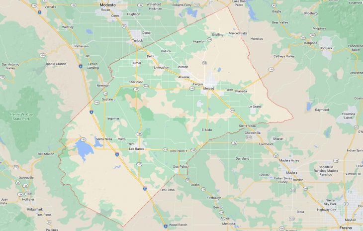
Cities and Towns in Merced County, California

Founded in 1855, Merced County is one of 58 counties in the state of California. Historically, Merced County was formed from Mariposa. The city of Merced is the county seat. With FIPS code of 47, Merced County has a population of 286,461 and area of 1,929 square miles (4,996 km²).

List of all cities in Merced County, CA alphabetically

City/Town Postal Code Area Code
Atwater, CA 95301 209
Ballico, CA 95303 209
Cressey, CA 95312 209
Delhi, CA 95315 209
Dos Palos, CA 93620 209
El Nido, CA 95317 209
Gustine, CA 95322 209
Hilmar, CA 95324 209
Le Grand, CA 95333 209
Livingston, CA 95334 209
Los Banos, CA 93635 209
Merced, CA 95340 209
95341 209
95343 209
95344 209
95348 209
Planada, CA 95365 209
Santa Nella, CA 95322 209
Santa Rita Park, CA 93661 209
Snelling, CA 95369 209
South Dos Palos, CA 93665 209
Stevinson, CA 95374 209
Winton, CA 95388 209

Major Cities and Towns in Merced County, California

Merced

Area, Population, and Geographic Coordinates

  • Area: 23.3 square miles
  • Population: Approximately 86,333 (as of 2020)
  • Zip Codes: 95340, 95341, 95348
  • Latitude: 37.3022° N
  • Longitude: 120.4820° W

Location and History

Merced is the county seat and largest city in Merced County, located in the heart of California’s San Joaquin Valley. The city was founded in 1872 as a railroad town by the Central Pacific Railroad and was named after the nearby Merced River. Merced quickly grew as an agricultural hub, benefiting from the fertile soil and access to water resources. The city’s economy has traditionally been based on agriculture, particularly the production of dairy, almonds, and other crops. In recent years, Merced has gained prominence as the home of the University of California, Merced (UC Merced), which opened in 2005 as the newest campus in the UC system. This development has brought growth and diversity to the city, making it a center for education and innovation in the region.

Major Schools and Landmarks

Merced is served by the Merced City School District and the Merced Union High School District, with notable schools including Merced High School and Golden Valley High School. UC Merced, the first American research university of the 21st century, is a major educational institution in the city, offering a wide range of undergraduate and graduate programs. Major landmarks in Merced include Applegate Park and Zoo, a family-friendly destination with a variety of animals and a playground, and the Merced Multicultural Arts Center, which hosts exhibitions and performances that reflect the city’s diverse community. The Merced Theatre, a historic venue in downtown Merced, has been restored to its former glory and now hosts live performances and events. The nearby Merced River provides opportunities for outdoor recreation, including fishing, kayaking, and picnicking. Merced’s combination of historical significance, educational institutions, and cultural attractions makes it the central city in Merced County.

Los Banos

Area, Population, and Geographic Coordinates

  • Area: 10.1 square miles
  • Population: Approximately 45,532 (as of 2020)
  • Zip Codes: 93635
  • Latitude: 37.0586° N
  • Longitude: 120.8499° W

Location and History

Los Banos is a city located in the western part of Merced County, in the San Joaquin Valley. The town was founded in the late 19th century and developed as an agricultural community, named after the nearby Los Banos Creek, which was a popular watering hole for cattle. Los Banos has historically been an important center for farming and ranching, with a focus on crops such as cotton, tomatoes, and dairy products. The city’s location along State Route 152 makes it a key transportation hub, connecting the Central Valley to the coastal regions of California. Over the years, Los Banos has grown into a thriving community with a mix of suburban and rural characteristics, attracting residents and businesses looking for a balance between city amenities and rural charm.

Major Schools and Landmarks

Los Banos is served by the Los Banos Unified School District, with Los Banos High School and Pacheco High School being the primary educational institutions. Major landmarks in Los Banos include the Los Banos Wildlife Area, a popular spot for birdwatching, hunting, and fishing, and the Los Banos Creek Reservoir, which offers opportunities for boating, fishing, and camping. The city’s historic downtown area features the Henry Miller Plaza, named after the prominent rancher and developer who played a key role in the city’s early growth. The annual Los Banos Spring Fair is a major event that celebrates the city’s agricultural heritage with livestock exhibits, parades, and entertainment. Los Banos’ combination of agricultural significance, educational institutions, and community events makes it an important city in Merced County.

Atwater

Area, Population, and Geographic Coordinates

  • Area: 6.1 square miles
  • Population: Approximately 31,970 (as of 2020)
  • Zip Codes: 95301
  • Latitude: 37.3472° N
  • Longitude: 120.6090° W

Location and History

Atwater is a city located just west of Merced, in the central part of Merced County. The city was founded in the late 19th century as a railroad town along the Southern Pacific Railroad and was named after Marshall D. Atwater, a prominent landowner in the area. Atwater developed as an agricultural community, with its economy centered on farming, particularly the production of almonds, dairy, and poultry. The city grew significantly during World War II with the establishment of Castle Air Force Base, which served as a major training facility for bomber crews. Although the base was closed in 1995, the site has been repurposed as Castle Commerce Center, which includes an aviation museum, business park, and educational facilities. Atwater’s history is closely tied to its agricultural roots and its role in supporting the military.

Major Schools and Landmarks

Atwater is served by the Atwater Elementary School District and the Merced Union High School District, with Atwater High School and Buhach Colony High School being the primary educational institutions. Major landmarks in Atwater include the Castle Air Museum, which features an extensive collection of military aircraft and exhibits on aviation history, and the Bloss Mansion, a historic home that offers a glimpse into the city’s early days. The nearby Applegate Park provides recreational opportunities with its sports fields, playgrounds, and picnic areas. The Atwater Fall Festival, held annually in the city, celebrates the community’s heritage with parades, live music, and family-friendly activities. Atwater’s combination of historical significance, educational institutions, and community events makes it an important city in Merced County.

Dos Palos

Area, Population, and Geographic Coordinates

  • Area: 1.4 square miles
  • Population: Approximately 5,798 (as of 2020)
  • Zip Codes: 93620
  • Latitude: 36.9852° N
  • Longitude: 120.6305° W

Location and History

Dos Palos is a small city located in the southwestern part of Merced County, near the border with Fresno County. The city was founded in the early 20th century and named after a nearby ranch called “Dos Palos,” which means “two trees” in Spanish. Dos Palos developed as an agricultural community, with its economy centered on farming and dairy production. The town’s location in the fertile San Joaquin Valley made it an ideal place for growing a variety of crops, including cotton, alfalfa, and tomatoes. Over the years, Dos Palos has retained its rural character and close-knit community atmosphere, with a focus on preserving its agricultural heritage.

Major Schools and Landmarks

Dos Palos is served by the Dos Palos-Oro Loma Joint Unified School District, with Dos Palos High School and Bryant Middle School being the primary educational institutions. Major landmarks in Dos Palos include the historic Dos Palos Branch Library, which has served the community since the early 20th century, and the nearby San Luis National Wildlife Refuge, which offers opportunities for wildlife observation, birdwatching, and exploring the natural wetlands of the region. The city’s annual Dos Palos Y Auction and Parade is a major event that celebrates the community’s agricultural roots with livestock auctions, parades, and entertainment. Dos Palos’ combination of agricultural significance, educational institutions, and rural charm makes it an important town in Merced County.

Gustine

Area, Population, and Geographic Coordinates

  • Area: 1.6 square miles
  • Population: Approximately 5,886 (as of 2020)
  • Zip Codes: 95322
  • Latitude: 37.2563° N
  • Longitude: 121.0038° W

Location and History

Gustine is a small city located in the western part of Merced County, near the intersection of State Routes 33 and 140. The city was founded in the early 20th century and named after Sarah “Gussie” Medeiros, the daughter of a prominent local rancher. Gustine developed as an agricultural community, with its economy based on dairy farming, crop production, and livestock. The city’s location in the San Joaquin Valley provided access to fertile farmland and irrigation, making it an ideal place for agriculture. Over the years, Gustine has maintained its rural character and strong sense of community, with a focus on preserving its agricultural traditions and small-town charm.

Major Schools and Landmarks

Gustine is served by the Gustine Unified School District, with Gustine High School and Gustine Middle School being the primary educational institutions. Major landmarks in Gustine include the historic Gustine Museum, which offers exhibits on the town’s history and the contributions of its early settlers, and the nearby San Luis Reservoir, a popular destination for boating, fishing, and camping. The city’s annual Festa do Espírito Santo, a Portuguese festival celebrating the Holy Spirit, reflects Gustine’s strong Portuguese heritage and attracts visitors from around the region. The nearby Great Valley Grasslands State Park offers opportunities for hiking and wildlife observation, showcasing the natural beauty of the San Joaquin Valley. Gustine’s combination of agricultural significance, educational institutions, and cultural heritage makes it an important town in Merced County.

Map of Cities in Merced County, CA

Map of Cities in Merced County, CA