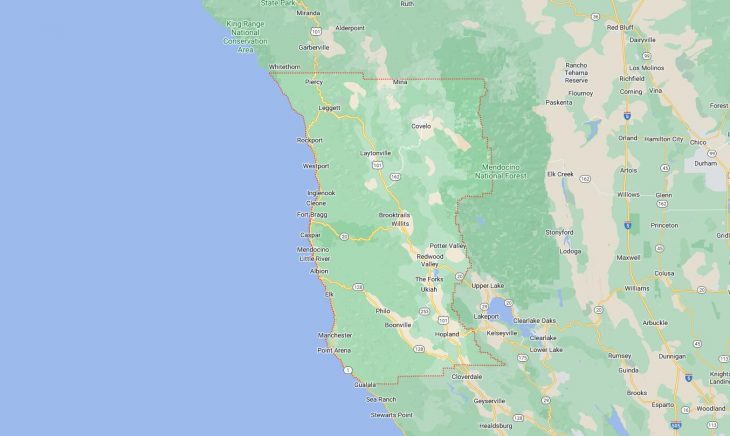
Cities and Towns in Mendocino County, California

Founded in 1850, Mendocino County is one of 58 counties in the state of California. The city of Ukiah is the county seat. With FIPS code of 45, Mendocino County has a population of 91,305 and area of 3,509 square miles (9,088 km²).

List of all cities in Mendocino County, CA alphabetically

City/Town Postal Code Area Code
Albion, CA 95410 707
Anchor Bay, CA 95445 707
Boonville, CA 95415 707
Branscomb, CA 95417 707
Calpella, CA 95418 707
Caspar, CA 95420 707
Cleone, CA 95437 707
Comptche, CA 95427 707
Covelo, CA 95428 707
Dos Rios, CA 95429 707
Elk, CA 95432 707
Fort Bragg, CA 95437 707
Fort Bragg, CA 95488 707
Gualala, CA 95445 707
Hopland, CA 95449 707
Inglenook, CA 95437 707
Keene Summit, CA 95427 707
Laytonville, CA 95417 707
95454 707
Laytonville Rancheria, CA 95454 707
Leggett, CA 95585 707
Little River, CA 95456 707
Littleriver, CA 95456 707
Manchester, CA 95459 707
Manchester Rancheria, CA 95459 707
Mendocino, CA 95460 707
Navarro, CA 95463 707
Noyo, CA 95437 707
Philo, CA 95463 707
95466 707
Piercy, CA 95587 707
Point Arena, CA 95468 707
Point Arena Air Force Statio, CA 95468 707
Potter Valley, CA 95469 707
Pudding Creek, CA 95437 707
Redwood Lodge, CA 95437 707
Redwood Valley, CA 95470 707
Rockport, CA 95488 707
Sherwood Valley Rancheria, CA 95437 707
Talmage, CA 95481 707
The Sea Ranch, CA 95445 707
Ukiah, CA 95418 707
95482 707
Westport, CA 95488 707
Willits, CA 95490 707
Yorkville, CA 95494 707

Major Cities and Towns in Mendocino County, California

Ukiah

Area, Population, and Geographic Coordinates

  • Area: 4.7 square miles
  • Population: Approximately 16,075 (as of 2020)
  • Zip Codes: 95482
  • Latitude: 39.1502° N
  • Longitude: 123.2078° W

Location and History

Ukiah is the county seat and largest city in Mendocino County, located in the northern part of California’s wine country, along U.S. Route 101. The city was founded in 1856 and developed as an agricultural hub, initially focused on fruit orchards and vineyards. Ukiah’s name is derived from the Pomo Native American word “Yokayo,” meaning “deep valley.” Over the years, Ukiah became a key center for commerce and government in the region. The city is known for its natural beauty, surrounded by rolling hills, vineyards, and the nearby Mendocino National Forest. Ukiah’s historic downtown area features a mix of preserved buildings, shops, and restaurants, reflecting its rich cultural heritage and community spirit.

Major Schools and Landmarks

Ukiah is served by the Ukiah Unified School District, with notable schools including Ukiah High School and Pomolita Middle School. Mendocino College, a community college offering a range of academic programs, is also located in the city. Major landmarks in Ukiah include the Grace Hudson Museum, which showcases the life and works of Grace Carpenter Hudson, a renowned painter of Native American portraits, and the City of Ten Thousand Buddhas, one of the largest Buddhist communities in the Western Hemisphere. The nearby Lake Mendocino offers opportunities for boating, fishing, and camping, making it a popular destination for outdoor enthusiasts. Ukiah’s combination of historical significance, educational institutions, and natural beauty makes it the central city in Mendocino County.

Fort Bragg

Area, Population, and Geographic Coordinates

  • Area: 2.7 square miles
  • Population: Approximately 6,983 (as of 2020)
  • Zip Codes: 95437
  • Latitude: 39.4457° N
  • Longitude: 123.8053° W

Location and History

Fort Bragg is a coastal city located along the rugged Northern California coastline, in Mendocino County. The town was founded in 1857 as a military fort, established to maintain order among the local Native American population. After the fort was abandoned in 1864, Fort Bragg transitioned into a logging town, with the abundant redwood forests fueling the local economy. The city’s location along the Pacific Ocean and its access to the timber resources made it a key hub for the logging industry. Today, Fort Bragg is known for its picturesque setting, with scenic views of the ocean, cliffs, and forests, making it a popular tourist destination.

Major Schools and Landmarks

Fort Bragg is served by the Fort Bragg Unified School District, with Fort Bragg High School and Fort Bragg Middle School being the primary educational institutions. Major landmarks in Fort Bragg include the Glass Beach, a unique shoreline covered in smooth, colorful sea glass, and the Mendocino Coast Botanical Gardens, which features a diverse collection of plants and flowers set against the backdrop of the Pacific Ocean. The Skunk Train, a historic railway offering scenic rides through the redwood forests, is another popular attraction in Fort Bragg. The Noyo Harbor, a working harbor and fishing village, offers opportunities for boat tours, fishing, and dining on fresh seafood. Fort Bragg’s combination of historical significance, educational institutions, and coastal charm makes it an important city in Mendocino County.

Willits

Area, Population, and Geographic Coordinates

  • Area: 2.8 square miles
  • Population: Approximately 4,988 (as of 2020)
  • Zip Codes: 95490
  • Latitude: 39.4093° N
  • Longitude: 123.3558° W

Location and History

Willits is a small city located in the heart of Mendocino County, along U.S. Route 101. The town was founded in the mid-19th century and named after Hiram Willits, an early settler and rancher. Willits developed as a key stop along the Northwestern Pacific Railroad, serving as a transportation and commercial hub for the region’s agricultural and logging industries. The city is known as the “Gateway to the Redwoods,” as it is located near some of the tallest and oldest redwood trees in the world. Willits has maintained its small-town charm, with a strong sense of community and a focus on preserving its natural surroundings.

Major Schools and Landmarks

Willits is served by the Willits Unified School District, with notable schools including Willits High School and Baechtel Grove Middle School. Major landmarks in Willits include the Mendocino County Museum, which offers exhibits on the region’s history, including its Native American heritage and the development of the railroad. The town is also home to the annual Willits Frontier Days, the oldest continuous rodeo in California, which celebrates the city’s Western heritage with parades, rodeo events, and community activities. The nearby Jackson State Forest offers hiking, camping, and exploring the majestic redwood forests, making Willits a popular destination for nature lovers. Willits’ combination of historical significance, educational institutions, and proximity to natural wonders makes it an important community in Mendocino County.

Mendocino

Area, Population, and Geographic Coordinates

  • Area: 7.8 square miles
  • Population: Approximately 894 (as of 2020)
  • Zip Codes: 95460
  • Latitude: 39.3073° N
  • Longitude: 123.7995° W

Location and History

Mendocino is a small coastal town located along the Pacific Ocean, known for its stunning natural beauty and historic charm. The town was founded in 1850 as a logging community, with its economy initially based on the timber industry. Mendocino’s location along the rugged coastline provided access to the rich redwood forests, and the town quickly grew as a center for logging and shipping. Over the years, Mendocino has evolved into a popular destination for artists, writers, and tourists, drawn by its scenic landscapes, charming Victorian architecture, and vibrant arts scene. The town’s well-preserved historic district has been designated as a National Historic Landmark, reflecting its cultural and architectural significance.

Major Schools and Landmarks

Mendocino is served by the Mendocino Unified School District, with Mendocino High School and Mendocino K-8 School being the primary educational institutions. Major landmarks in Mendocino include the Mendocino Headlands State Park, which offers dramatic views of the ocean and cliffs, and the Mendocino Art Center, a cultural hub that offers workshops, exhibitions, and performances. The Kelley House Museum, located in a historic home, provides insights into the town’s history and development. The nearby Big River offers opportunities for kayaking, canoeing, and exploring the estuary and surrounding forests. Mendocino’s combination of historical significance, educational institutions, and artistic culture makes it a unique and important community in Mendocino County.

Point Arena

Area, Population, and Geographic Coordinates

  • Area: 1.4 square miles
  • Population: Approximately 444 (as of 2020)
  • Zip Codes: 95468
  • Latitude: 38.9088° N
  • Longitude: 123.6936° W

Location and History

Point Arena is a small coastal city located along the Pacific Ocean, in the southwestern part of Mendocino County. The town was founded in the mid-19th century as a shipping and fishing village, with its economy centered on the timber and fishing industries. Point Arena is known for its dramatic coastline, with rocky cliffs and secluded beaches offering stunning views of the ocean. The town’s history is closely tied to its maritime heritage, with the Point Arena Lighthouse serving as a key navigational aid for ships along the rugged Northern California coast. Today, Point Arena is a quiet, rural community with a focus on preserving its natural surroundings and maritime history.

Major Schools and Landmarks

Point Arena is served by the Arena Union Elementary School District and the Point Arena Joint Union High School District, with Point Arena High School and Arena Union Elementary School being the primary educational institutions. Major landmarks in Point Arena include the Point Arena Lighthouse, a historic structure that offers tours and panoramic views of the coastline, and the Point Arena-Stornetta Public Lands, which provide access to some of the most scenic coastal landscapes in Northern California. The town’s small downtown area features shops, galleries, and restaurants, reflecting its artistic and community-oriented character. Point Arena’s combination of historical significance, educational institutions, and coastal beauty makes it an important community in Mendocino County.

Map of Cities in Mendocino County, CA

Map of Cities in Mendocino County, CA