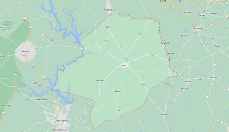
Cities and Towns in Hancock County, Georgia

Founded in 1793, Hancock County is one of 159 counties in the state of Georgia. Historically, Hancock County was formed from Greene and Washington counties. The city of Sparta is the county seat. With FIPS code of 141, Hancock County has a population of 8,630 and area of 473 square miles (1,225 km²).

List of all cities in Hancock County, GA alphabetically

City/Town Postal Code Area Code
Mayfield, GA 31087 706/762
Sparta, GA 31087 706/762

Major Cities and Towns in Hancock County, Georgia

Sparta

Area, Population, Zip Codes, Latitude, and Longitude

  • Area: 1.8 square miles
  • Population: 1,226 (as of the 2020 census)
  • Zip Codes: 31087
  • Latitude: 33.2785° N
  • Longitude: 82.9718° W

Location and History

Sparta is the county seat of Hancock County, located in the central part of Georgia. Founded in 1795, Sparta was named after the ancient Greek city-state, reflecting the classical influences of the time. The city quickly grew into a center of wealth and culture in the Antebellum South, largely due to the prosperity brought by cotton plantations. Sparta’s historic district boasts a collection of well-preserved antebellum homes, churches, and public buildings, many of which are listed on the National Register of Historic Places. The city was a hub for education and intellectual life in the 19th century, with several private academies and colleges operating during that time. However, like much of the South, Sparta faced economic hardships following the Civil War, which led to a slow decline. Today, Sparta retains its historical charm and is known for its rich architectural heritage and serene, small-town atmosphere.

Major Schools and Landmarks

Sparta is served by the Hancock County School District, with Hancock Central High School and Lewis Elementary School being key educational institutions. The city’s landmarks include the Hancock County Courthouse, a striking example of Greek Revival architecture that has been central to the county’s governance since its construction in 1881. Other notable sites include the historic Sparta Cemetery, where many of the county’s early settlers and prominent citizens are buried, and the Linton Park, a popular spot for community gatherings and events. Sparta’s annual festivals, such as the Sparta-Hancock County Bicentennial Festival, celebrate the city’s long history and cultural heritage.

Devereux

Area, Population, Zip Codes, Latitude, and Longitude

  • Area: 0.3 square miles
  • Population: 105 (as of the 2020 census)
  • Zip Codes: 31087
  • Latitude: 33.2396° N
  • Longitude: 83.0837° W

Location and History

Devereux is a small town located in the northeastern part of Hancock County. Established in the early 19th century, the town was named after a prominent local family, the Devereuxs, who were influential in the area’s development. Devereux has always been a small, rural community, primarily supported by agriculture. The town grew around a central crossroads, serving as a local trading post and social hub for nearby farmers and residents. Over the years, Devereux has remained largely unchanged, maintaining its quiet, rural character amidst the rolling farmlands and forests of Hancock County. Despite its small size, Devereux is rich in Southern charm and history, offering a glimpse into the county’s past.

Major Schools and Landmarks

As a small community, Devereux does not have its own school system, with students typically attending schools in Sparta or other nearby towns. The town’s most notable landmark is the Devereux Baptist Church, which has been a central part of the community since its founding in the 19th century. The surrounding countryside is dotted with historic homes and farms, many of which have been in the same families for generations. The rural setting also offers opportunities for outdoor activities, such as hunting and fishing, which are popular pastimes in the area. Devereux’s annual events, like local church gatherings and festivals, help maintain the town’s close-knit community spirit.

Mayfield

Area, Population, Zip Codes, Latitude, and Longitude

  • Area: 0.5 square miles
  • Population: 142 (as of the 2020 census)
  • Zip Codes: 31087
  • Latitude: 33.2937° N
  • Longitude: 82.8042° W

Location and History

Mayfield is a small town located in the southern part of Hancock County, near the border with Washington County. The town was established in the mid-19th century and was originally a stop on the Augusta-to-Macon stagecoach route. Mayfield was named after a local family and became a modest agricultural center, with cotton farming as the primary economic activity. The arrival of the railroad in the late 19th century briefly spurred growth, but the town has remained small and rural throughout its history. Today, Mayfield is a quiet community, known for its peaceful rural setting and historic charm. The town offers a window into the agricultural history of Hancock County, with many historic farms and buildings still in use.

Major Schools and Landmarks

Mayfield is part of the Hancock County School District, with students typically attending schools in Sparta. The town is home to several historic landmarks, including the Mayfield Baptist Church, which has been a cornerstone of the community for over a century. The surrounding area is also known for its historic homes, many of which date back to the 19th century and reflect the town’s agricultural past. Additionally, Mayfield’s proximity to the Ogeechee River makes it a popular spot for fishing and other outdoor activities. The town’s annual events, such as community picnics and church gatherings, play a significant role in maintaining its strong sense of community and preserving its historical legacy.

Jewell

Area, Population, Zip Codes, Latitude, and Longitude

  • Area: 1.0 square mile
  • Population: 55 (as of the 2020 census)
  • Zip Codes: 31045
  • Latitude: 33.2891° N
  • Longitude: 82.7845° W

Location and History

Jewell is a small, unincorporated community located in the southeastern part of Hancock County, near the Ogeechee River. The town was established in the early 19th century and was originally known as “Jewell’s Mill,” named after the local Jewell family who operated a gristmill and sawmill on the river. Jewell became a minor industrial center in the region, with the mill serving as the economic heart of the community. The town played a role in the agricultural and industrial history of Hancock County, with its mill providing services to local farmers and contributing to the region’s economy. Today, Jewell is a quiet, rural community with a rich history that is preserved in its historic buildings and natural surroundings.

Major Schools and Landmarks

Jewell does not have its own school system, with students typically attending schools in nearby towns such as Sparta or Sandersville. The most prominent landmark in Jewell is the historic Jewell Mill, which dates back to the 19th century and is one of the oldest continuously operating mills in the state of Georgia. The mill is a key part of the community’s identity and a reminder of its industrial past. The town is also home to several historic homes and churches, reflecting its long history. The nearby Ogeechee River offers opportunities for fishing, boating, and other outdoor activities, making Jewell a popular spot for nature enthusiasts. The community’s small size and rural setting make it a peaceful retreat, with a strong sense of history and tradition.

Map of Cities in Hancock County, GA

Map of Cities in Hancock County, GA