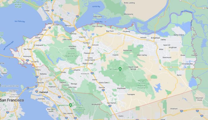
Cities and Towns in Contra Costa County, California
Founded in 1850, Contra Costa County is one of 58 counties in the state of California. The city of Martinez is the county seat. With FIPS code of 13, Contra Costa County has a population of 1,161,413 and area of 720 square miles (1,865 km²).
List of all cities in Contra Costa County, CA alphabetically
City/Town | Postal Code | Area Code |
Alamo, CA | 94507 | 925 |
Antioch, CA | 94509 | 925 |
94531 | 925 | |
Bay Point, CA | 94565 | 925 |
Bethel Island, CA | 94511 | 925 |
Blackhawk, CA | 94506 | 925 |
Brentwood, CA | 94513 | 925 |
Briones, CA | 94553 | 925 |
Byron, CA | 94505 | 510 |
94514 | 925 | |
Canyon, CA | 94516 | 925 |
Chevron, CA | 94529 | 925 |
Chevron USA Inc, CA | 94529 | 925 |
Clayton, CA | 94517 | 925 |
Clyde, CA | 94520 | 925 |
Concord, CA | 94518 | 925 |
94519 | 925 | |
94520 | 925 | |
94521 | 925 | |
94522 | 925 | |
94523 | 925 | |
94524 | 925 | |
94527 | 925 | |
94529 | 925 | |
Crockett, CA | 94525 | 510 |
Danville, CA | 94506 | 925 |
94526 | 925 | |
Diablo, CA | 94528 | 925 |
Discovery Bay, CA | 94505 | 510 |
Discovery Bay, CA | 94514 | 925 |
El Cerrito, CA | 94530 | 510 |
El Sobrante, CA | 94803 | 510 |
94820 | 510 | |
Hercules, CA | 94547 | 510 |
Hilltop Mall, CA | 94806 | 510 |
Knightsen, CA | 94548 | 510 |
Lafayette, CA | 94549 | 925 |
94596 | 925 | |
Martinez, CA | 94553 | 925 |
Moraga, CA | 94556 | 925 |
94570 | 925 | |
94575 | 925 | |
North Richmond, CA | 94801 | 510 |
Oakley, CA | 94561 | 925 |
Orinda, CA | 94563 | 925 |
Pacheco, CA | 94553 | 925 |
Pinole, CA | 94564 | 510 |
Pittsburg, CA | 94565 | 925 |
Pleasant Hill, CA | 94523 | 925 |
Point Richmond, CA | 94801 | 510 |
Port Chicago, CA | 94565 | 925 |
Port Costa, CA | 94569 | 510 |
Richmond, CA | 94801 | 510 |
94802 | 510 | |
94803 | 510 | |
94804 | 510 | |
94805 | 510 | |
94806 | 510 | |
94807 | 510 | |
94808 | 510 | |
94820 | 510 | |
94850 | 510 | |
Rodeo, CA | 94547 | 510 |
94572 | 510 | |
San Pablo, CA | 94803 | 510 |
94806 | 510 | |
San Ramon, CA | 94582 | 925 |
94583 | 925 | |
Tara Hills, CA | 94806 | 510 |
Walnut Creek, CA | 94595 | 925 |
94596 | 925 | |
94597 | 925 | |
94598 | 925 | |
West Pittsburg, CA | 94565 | 925 |
Major Cities and Towns in Contra Costa County, California
Concord
Area, Population, and Geographic Coordinates
- Area: 30.55 square miles
- Population: Approximately 129,295 (as of 2020)
- Zip Codes: 94518, 94519, 94520, 94521, 94522, 94523, 94524, 94527, 94529
- Latitude: 37.9775° N
- Longitude: 122.0311° W
Location and History
Concord is the largest city in Contra Costa County, located in the East Bay region of the San Francisco Bay Area. The city was founded in 1869 as Todos Santos by Don Salvio Pacheco, a Californio ranchero who owned the land. The name was later changed to Concord in 1869. Concord developed as an agricultural center, particularly known for its wheat, fruit orchards, and vineyards. During World War II, the nearby Port Chicago Naval Magazine brought significant military activity to the area, which had a lasting impact on the city’s growth. Today, Concord is a suburban city with a diverse economy, strong cultural ties, and a well-preserved downtown area that features the original town square, Todos Santos Plaza, which remains a focal point for community events and gatherings.
Major Schools and Landmarks
Concord is served by the Mount Diablo Unified School District, with notable schools including Concord High School, Clayton Valley Charter High School, and Ygnacio Valley High School. The city is home to several major landmarks, such as the Sleep Train Pavilion (formerly Concord Pavilion), an outdoor concert venue that hosts a wide range of musical performances. Todos Santos Plaza, the heart of downtown Concord, is surrounded by shops, restaurants, and hosts weekly farmers’ markets and summer concerts. The nearby Lime Ridge Open Space offers miles of hiking and biking trails with scenic views of the East Bay hills. Concord’s combination of historical significance, educational institutions, and recreational opportunities make it a key city in Contra Costa County.
Richmond
Area, Population, and Geographic Coordinates
- Area: 52.51 square miles
- Population: Approximately 110,567 (as of 2020)
- Zip Codes: 94801, 94802, 94803, 94804, 94805, 94806, 94807, 94808, 94820, 94850
- Latitude: 37.9358° N
- Longitude: 122.3478° W
Location and History
Richmond is located on the western edge of Contra Costa County, along the eastern shore of the San Francisco Bay. The city was incorporated in 1905 and rapidly developed as an industrial hub, particularly during World War II when the Kaiser Shipyards were established to build ships for the war effort. This brought a significant influx of workers and led to Richmond becoming a major center for the defense industry. The city has a rich cultural history, shaped by the diverse communities that settled in the area during and after the war. Today, Richmond is a vibrant city with a mix of residential, commercial, and industrial areas, and it plays a vital role in the region’s economy.
Major Schools and Landmarks
Richmond is served by the West Contra Costa Unified School District, with notable schools including Richmond High School and Kennedy High School. The city is home to several historic and cultural landmarks, such as the Rosie the Riveter/World War II Home Front National Historical Park, which commemorates the contributions of American workers during the war. Point Richmond, the city’s oldest neighborhood, features Victorian-style homes, galleries, and restaurants, offering a glimpse into the city’s past. The Richmond Marina and the San Francisco Bay Trail provide scenic views and outdoor recreational opportunities. Richmond’s combination of industrial history, cultural diversity, and scenic waterfronts make it a unique and important city in Contra Costa County.
Antioch
Area, Population, and Geographic Coordinates
- Area: 29.09 square miles
- Population: Approximately 115,291 (as of 2020)
- Zip Codes: 94509, 94531
- Latitude: 38.0049° N
- Longitude: 121.8058° W
Location and History
Antioch is located in the northeastern part of Contra Costa County, along the banks of the San Joaquin River. The city was founded in 1850 as Smith’s Landing, named after the two brothers who established the first settlement in the area. It was later renamed Antioch, after the ancient city in Turkey. Antioch grew as a center for agriculture, particularly wheat and cattle ranching, and later developed into a major industrial area with the establishment of factories and mills. The city experienced significant growth in the latter half of the 20th century, becoming a suburban community with a diverse population. Today, Antioch is known for its historic downtown, scenic waterfront, and access to the Delta region.
Major Schools and Landmarks
Antioch is served by the Antioch Unified School District, with notable schools including Antioch High School and Deer Valley High School. The city’s major landmarks include the Antioch Historical Society Museum, which preserves the history of the area, and the historic Rivertown district, featuring shops, restaurants, and the El Campanil Theatre, which dates back to 1928. The Contra Loma Regional Park offers outdoor recreational activities, including hiking, fishing, and picnicking, while the Black Diamond Mines Regional Preserve provides insights into the area’s mining history with tours of old coal mines. Antioch’s combination of historical significance, educational institutions, and recreational opportunities make it a key city in Contra Costa County.
Walnut Creek
Area, Population, and Geographic Coordinates
- Area: 19.77 square miles
- Population: Approximately 70,127 (as of 2020)
- Zip Codes: 94595, 94596, 94597, 94598
- Latitude: 37.9101° N
- Longitude: 122.0652° W
Location and History
Walnut Creek is centrally located in Contra Costa County and serves as a regional hub for shopping, dining, and entertainment in the East Bay. The area was originally inhabited by the indigenous Bay Miwok people before becoming a Mexican land grant in the early 19th century. The town of Walnut Creek was officially founded in 1849 and grew rapidly with the arrival of the Southern Pacific Railroad in the late 19th century. The city evolved from an agricultural community into a bustling suburban center, known for its high quality of life, excellent schools, and extensive open spaces. Walnut Creek is often considered the cultural and commercial heart of Contra Costa County, with its vibrant downtown and numerous parks.
Major Schools and Landmarks
Walnut Creek is served by several school districts, including the Walnut Creek School District and the Acalanes Union High School District, with notable schools such as Las Lomas High School and Northgate High School. The city is home to several major landmarks, including the Lesher Center for the Arts, which hosts performances and exhibitions, and the Ruth Bancroft Garden, a renowned public garden featuring drought-resistant plants. The downtown area is known for its upscale shopping and dining, with Broadway Plaza being a key destination. The nearby Mount Diablo State Park offers hiking trails and panoramic views of the Bay Area, making Walnut Creek a popular spot for outdoor enthusiasts. Walnut Creek’s blend of cultural amenities, educational excellence, and natural beauty make it a standout city in Contra Costa County.
San Ramon
Area, Population, and Geographic Coordinates
- Area: 18.63 square miles
- Population: Approximately 84,605 (as of 2020)
- Zip Codes: 94582, 94583
- Latitude: 37.7799° N
- Longitude: 121.9780° W
Location and History
San Ramon is located in the southern part of Contra Costa County, in the San Ramon Valley. The area was originally inhabited by the Seunen people, a branch of the Bay Miwok, before becoming part of a Mexican land grant known as Rancho San Ramon. The town grew slowly in the 19th century, primarily as an agricultural community. However, San Ramon experienced rapid growth and suburban development in the latter half of the 20th century, becoming one of the most affluent cities in the East Bay. The city is home to several corporate headquarters, including Chevron and 24 Hour Fitness, which contribute to its strong economy. San Ramon is known for its family-friendly environment, excellent schools, and well-planned communities.
Major Schools and Landmarks
San Ramon is served by the San Ramon Valley Unified School District, with top-rated schools such as California High School and Dougherty Valley High School. The city’s major landmarks include Central Park, a large community park that hosts events, sports, and outdoor activities, and the Bishop Ranch Regional Preserve, offering trails and natural beauty in the heart of the city. The city’s downtown area, City Center Bishop Ranch, is a modern mixed-use development that features shopping, dining, entertainment, and community events. The San Ramon Valley Museum provides insights into the area’s history, from its indigenous roots to its development as a suburban community. San Ramon’s combination of economic strength, educational institutions, and quality of life make it an important city in Contra Costa County.
Martinez
Area, Population, and Geographic Coordinates
- Area: 12.63 square miles
- Population: Approximately 38,290 (as of 2020)
- Zip Codes: 94553
- Latitude: 38.0194° N
- Longitude: 122.1341° W
Location and History
Martinez is the county seat of Contra Costa County, located along the Carquinez Strait in the northeastern part of the county. The city was founded in 1849 and is one of the oldest towns in California. Martinez became a significant shipping and trading center during the California Gold Rush, with its location along the Sacramento River making it a key port for goods and passengers. The city is also known as the birthplace of baseball legend Joe DiMaggio and for its historic downtown, which features a number of well-preserved buildings from the 19th century. Today, Martinez is a charming suburban community with a strong sense of history and a picturesque waterfront.
Major Schools and Landmarks
Martinez is served by the Martinez Unified School District, with notable schools including Alhambra High School and Martinez Junior High School. The city’s major landmarks include the John Muir National Historic Site, the former home of naturalist John Muir, which offers tours and educational programs about his life and work. The Martinez Marina and waterfront area provide opportunities for boating, fishing, and enjoying scenic views of the Carquinez Strait. The city’s historic downtown features a variety of shops, restaurants, and cultural venues, including the Martinez Historical Society Museum. Martinez’s combination of historical significance, natural beauty, and community amenities make it a key city in Contra Costa County.