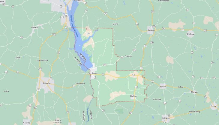
Cities and Towns in Clay County, Georgia
Founded in 1854, Clay County is one of 159 counties in the state of Georgia. Historically, Clay County was formed from Randolph and Early counties. The city of Fort Gaines is the county seat. With FIPS code of 61, Clay County has a population of 2,882 and area of 195 square miles (505 km²).
List of all cities in Clay County, GA alphabetically
City/Town | Postal Code | Area Code |
Bluffton, GA | 39824 | 229 |
Fort Gaines, GA | 39851 | 229 |
Major Cities and Towns in Clay County, Georgia
Fort Gaines
Area, Population, Zip Codes, and Coordinates
- Area: 3.5 square miles
- Population: Approximately 1,000
- Zip Codes: 39851
- Latitude: 31.6099° N
- Longitude: 85.0486° W
City Location and History
Fort Gaines, the county seat of Clay County, is located in southwestern Georgia along the banks of the Chattahoochee River. The city was established in 1816 as a military fort during the period of tension between settlers and Native American tribes. Named after General Edmund Pendleton Gaines, the fort played a crucial role in protecting settlers and maintaining peace in the region. Over time, Fort Gaines evolved from a military outpost into a thriving river town, with steamboat traffic on the Chattahoochee River driving its economy in the 19th century. The construction of the Walter F. George Lock and Dam in the 1960s transformed the area, creating Lake Walter F. George (also known as Lake Eufaula), which is a major recreational and economic asset for the city today.
Major Schools and Landmarks
Fort Gaines is served by the Clay County School District, with Clay County Elementary and Clay County High School providing education to local students. The city is home to several historic landmarks, including the Fort Gaines Historic District, which features well-preserved antebellum homes and buildings. Another significant landmark is the George T. Bagby State Park and Lodge, which offers outdoor activities such as fishing, boating, and hiking along the shores of Lake Walter F. George. The city’s rich history and natural beauty make Fort Gaines a unique destination within southwestern Georgia.
Bluffton
Area, Population, Zip Codes, and Coordinates
- Area: 0.8 square miles
- Population: Approximately 100
- Zip Codes: 39824
- Latitude: 31.5276° N
- Longitude: 84.8688° W
City Location and History
Bluffton is a small town located in the northern part of Clay County, Georgia. The town was incorporated in 1880 and has a history deeply rooted in agriculture, with cotton being the dominant crop during the 19th and early 20th centuries. Bluffton’s location on the high ground above the surrounding plains gave it strategic importance in the region. Despite its small size, Bluffton has maintained a close-knit community atmosphere, with much of its original character preserved over the years. The town’s economy has remained primarily agricultural, with small-scale farming still playing a role in the local economy.
Major Schools and Landmarks
Bluffton does not have its own school system; instead, students attend schools in nearby Fort Gaines within the Clay County School District. The town is known for its historical significance, with several buildings from the 19th century still standing. Notable landmarks include the Bluffton Baptist Church, which has been a central part of the community for over a century. The surrounding countryside offers scenic views and a tranquil rural environment, making Bluffton a peaceful place to live. The town’s small size and historical preservation contribute to its charm and sense of community.
Coleman
Area, Population, Zip Codes, and Coordinates
- Area: 0.6 square miles
- Population: Approximately 150
- Zip Codes: 39836
- Latitude: 31.6752° N
- Longitude: 84.8924° W
City Location and History
Coleman is a small, unincorporated community located in the northeastern part of Clay County, Georgia. Established in the late 19th century, Coleman was once a bustling town with a vibrant agricultural economy. The town’s location along the railroad made it an important shipping point for cotton and other crops grown in the surrounding area. Over the years, Coleman’s population has declined, and it has become a quiet, rural community. Despite its reduced size, the town has retained much of its historical character, with several old buildings and homes still standing as a testament to its past.
Major Schools and Landmarks
Education for residents of Coleman is provided by the Clay County School District, with schools located in Fort Gaines. While Coleman does not have significant landmarks of its own, its proximity to Fort Gaines and the historical and recreational opportunities available there make it an appealing location for those seeking a rural lifestyle. The nearby Pataula Creek, which flows into Lake Walter F. George, offers opportunities for fishing and outdoor activities. Coleman’s rural setting and historical roots make it a peaceful and picturesque place to live within Clay County.