Cities and Towns in Wakulla County, Florida
Founded in 1843, Wakulla County is one of 67 counties in the state of Florida. Historically, Wakulla County was formed from Leon. The city of Crawfordville is the county seat. With FIPS code of 129, Wakulla County has a population of 34,690 and area of 607 square miles (1,572 km²).
List of all cities in Wakulla County, FL alphabetically
City/Town | Postal Code | Area Code |
Alligator Point, FL | 32346 | 850 |
Crawfordville, FL | 32326 | 850 |
32327 | 850 | |
Ochlockonee, FL | 32346 | 850 |
Ochlockonee Bay, FL | 32346 | 850 |
Panacea, FL | 32346 | 850 |
Saint Marks, FL | 32355 | 850 |
Saint Teresa, FL | 32358 | 850 |
Sopchoppy, FL | 32358 | 850 |
Wakulla Springs, FL | 32327 | 850 |
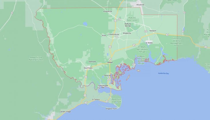
Major Cities and Towns in Wakulla County, Florida
Crawfordville
Area, Population, Zip Codes, and Coordinates
- Area: 4.2 square miles
- Population: Approximately 3,702 (2020 Census)
- Zip Codes: 32327
- Latitude and Longitude: 30.1763° N, 84.3758° W
Location and History
Crawfordville is the county seat and largest community in Wakulla County, located in the Florida Panhandle, just south of Tallahassee. The town was established in the early 19th century and named after Dr. John L. Crawford, a prominent physician and Secretary of State of Florida. Crawfordville has historically served as the administrative and commercial center of Wakulla County, with its economy traditionally based on agriculture, particularly in the production of tobacco, cotton, and timber. Over the years, Crawfordville has grown from a rural outpost into a small but thriving community, offering residents a quiet, rural lifestyle with easy access to the natural beauty of the region, including the nearby Apalachicola National Forest and Wakulla Springs.
Major Schools and Landmarks
Crawfordville is served by the Wakulla County School District, with Wakulla High School and Crawfordville Elementary School being the primary educational institutions. The town is also home to the Wakulla County Public Library, which serves as a central hub for learning and community activities. Major landmarks in Crawfordville include the historic Old Wakulla County Courthouse, a symbol of the town’s heritage, and the nearby Wakulla Springs State Park, home to one of the largest and deepest freshwater springs in the world. The park offers opportunities for swimming, boating, and wildlife viewing, making it a popular destination for residents and visitors alike.
Sopchoppy
Area, Population, Zip Codes, and Coordinates
- Area: 1.8 square miles
- Population: Approximately 460 (2020 Census)
- Zip Codes: 32358
- Latitude and Longitude: 30.0594° N, 84.4921° W
Location and History
Sopchoppy is a small town located in the western part of Wakulla County, near the Ochlockonee River. The town was established in the late 19th century and was originally a hub for the turpentine and timber industries. Sopchoppy’s name is believed to be derived from the Muscogee word “lockchoppe,” meaning “river.” The town is known for its close-knit community and its natural surroundings, including the nearby Apalachicola National Forest and the Ochlockonee River State Park. Sopchoppy has a rich cultural heritage, with a strong emphasis on preserving its history and natural environment. The town is famous for its annual Worm Gruntin’ Festival, celebrating the traditional method of earthworm harvesting.
Major Schools and Landmarks
Sopchoppy is served by the Wakulla County School District, with students attending schools in nearby Crawfordville, such as Wakulla High School. The town is also home to the historic Sopchoppy School, now a community center that hosts local events and activities. Major landmarks in Sopchoppy include the Sopchoppy Depot, a restored historic railroad station that serves as a museum and visitor center, and the Ochlockonee River State Park, offering opportunities for camping, fishing, and hiking in a pristine natural setting. The Apalachicola National Forest, located just outside of Sopchoppy, provides additional recreational opportunities, making the town a gateway to exploring the natural beauty of the Florida Panhandle.
St. Marks
Area, Population, Zip Codes, and Coordinates
- Area: 0.8 square miles
- Population: Approximately 300 (2020 Census)
- Zip Codes: 32355
- Latitude and Longitude: 30.1591° N, 84.2060° W
Location and History
St. Marks is a historic coastal town located at the confluence of the St. Marks and Wakulla Rivers, near the Gulf of Mexico. The town was established in the 17th century as a Spanish fort, making it one of the oldest settlements in Florida. St. Marks played a significant role in the early history of the region, serving as a strategic military and trading post. The town’s history is closely tied to the development of the St. Marks Lighthouse, one of Florida’s oldest lighthouses, which guided ships into the port for centuries. Today, St. Marks is a small, peaceful community known for its historic charm, scenic beauty, and outdoor recreational opportunities.
Major Schools and Landmarks
St. Marks is served by schools in nearby Crawfordville, with students attending Wakulla High School and other district schools. Major landmarks in St. Marks include the St. Marks Lighthouse, a historic structure that stands as a symbol of the town’s maritime heritage, and the San Marcos de Apalache Historic State Park, which preserves the site of the original Spanish fort and offers a museum and walking trails. The town is also a gateway to the St. Marks National Wildlife Refuge, a vast protected area that provides habitat for a diverse array of wildlife and offers opportunities for birdwatching, fishing, and kayaking. The town’s proximity to the Gulf of Mexico makes it a popular destination for outdoor enthusiasts and history buffs alike.