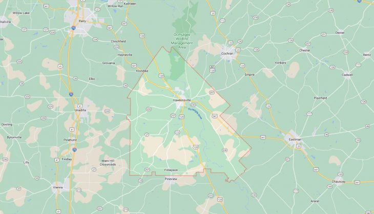
Cities and Towns in Pulaski County, Georgia

Founded in 1808, Pulaski County is one of 159 counties in the state of Georgia. Historically, Pulaski County was formed from Laurens County. The city of Hawkinsville is the county seat. With FIPS code of 235, Pulaski County has a population of 9,917 and area of 247 square miles (640 km²).

List of all cities in Pulaski County, GA alphabetically

City/Town Postal Code Area Code
Grovania, GA 31036 478
Hawkinsville, GA 31036 478
Hayneville, GA 31036 478
Hville, GA 31036 478
Klondike, GA 31036 478

Major Cities and Towns in Pulaski County, Georgia

Hawkinsville

Overview

Hawkinsville, the county seat of Pulaski County, is a city with a rich historical heritage and a vibrant community. Established in the early 19th century, Hawkinsville was named after Colonel Benjamin Hawkins, a prominent figure in the American Revolutionary War. The city is located on the banks of the Ocmulgee River, which played a crucial role in its early development as a transportation and trade hub. Hawkinsville’s economy was historically driven by agriculture, particularly cotton, and the city became known as the “Queen City of the Wiregrass.” The town’s historic district features well-preserved antebellum homes and buildings, reflecting its deep roots in Georgia’s history. Today, Hawkinsville continues to thrive as a small city with a strong sense of community and a rich cultural heritage.

Key Information

  • Area: Approximately 5.1 square miles
  • Population: Around 4,500 (latest census)
  • Zip Codes: 31036
  • Latitude: 32.2835° N
  • Longitude: 83.4727° W

Schools and Landmarks

Hawkinsville is served by the Pulaski County School District, with Hawkinsville High School and Pulaski County Elementary School being the primary educational institutions. The city is also home to several historic landmarks, including the Hawkinsville Opera House, which has been restored and serves as a cultural center for the community. Another significant landmark is the Pulaski County Courthouse, a historic building that stands as a testament to the city’s long history. The Ocmulgee River provides opportunities for outdoor recreation, with the Hawkinsville Riverfront Park being a popular spot for fishing, boating, and picnicking.


Hartford

Overview

Hartford is a small, unincorporated community in Pulaski County, located just a few miles northeast of Hawkinsville. Although not officially a city, Hartford has historical significance as one of the earliest settlements in the region. Established in the early 19th century, Hartford served as a key trading post and was once considered as a potential county seat before Hawkinsville was chosen. The community is situated near the Ocmulgee River, which played a crucial role in its development. Hartford’s history is closely tied to the agricultural heritage of Pulaski County, with cotton and other crops being the primary economic drivers. Over time, Hartford has remained a quiet, rural community with a strong connection to its historical roots.

Key Information

  • Area: Approximately 1.0 square miles
  • Population: Around 250 (latest estimate)
  • Zip Codes: 31036
  • Latitude: 32.3112° N
  • Longitude: 83.4603° W

Schools and Landmarks

As a small community, Hartford does not have its own schools, with students typically attending schools in nearby Hawkinsville. Despite its size, Hartford is home to several historical landmarks, including the Hartford Baptist Church, which has served the community for over a century. The nearby Ocmulgee River is a natural landmark that provides opportunities for outdoor activities such as fishing and boating. The community’s proximity to Hawkinsville allows residents to enjoy the amenities and cultural events of the larger city while maintaining the peace and quiet of rural living.


Crossroads

Overview

Crossroads is a small, unincorporated community in Pulaski County, known for its rural charm and close-knit community. The area was established in the late 19th century as a crossroads for several important trading routes, which gave the community its name. Crossroads has remained a predominantly agricultural area, with farming being the mainstay of its economy. The community is characterized by its rolling farmland, scattered homesteads, and a strong sense of tradition. Although small, Crossroads plays an important role in the agricultural landscape of Pulaski County, contributing to the region’s production of cotton, peanuts, and other crops.

Key Information

  • Area: Approximately 1.5 square miles
  • Population: Around 150 (latest estimate)
  • Zip Codes: 31036
  • Latitude: 32.3012° N
  • Longitude: 83.4937° W

Schools and Landmarks

Crossroads does not have its own schools, with children attending educational institutions in nearby Hawkinsville. The community is home to several notable landmarks, including the Crossroads Methodist Church, which has been a center of worship and community gatherings for over a century. The surrounding farmland and rural landscapes are a significant part of the community’s identity, providing a picturesque backdrop for this small, agricultural hub. The community’s location at the intersection of historic trade routes adds to its historical significance in the region.

Map of Cities in Pulaski County, GA

Map of Cities in Pulaski County, GA