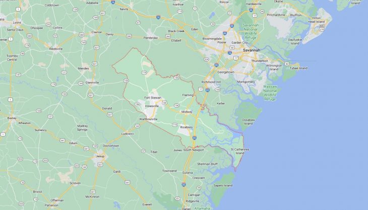
Cities and Towns in Liberty County, Georgia

Founded in 1777, Liberty County is one of 159 counties in the state of Georgia. Historically, Liberty County was formed from St Andrew, St James, and St John Parishes. The city of Hinesville is the county seat. With FIPS code of 179, Liberty County has a population of 65,711 and area of 519 square miles (1,344 km²).

List of all cities in Liberty County, GA alphabetically

City/Town Postal Code Area Code
Allenhurst, GA 31301 912
Fleming, GA 31309 912
Flemington, GA 31313 912
Fort Stewart, GA 31313 912
31314 912
31315 912
Gum Branch, GA 31313 912
Hinesville, GA 31310 912
31313 912
31314 912
31315 912
Jones, GA 31323 912
Midway, GA 31320 912
Retreat, GA 31323 912
Riceboro, GA 31323 912
South Newport, GA 31323 912
Walthourville, GA 31333 912

Major Cities and Towns in Liberty County, Georgia

Hinesville

Area, Population, Zip Codes, Latitude and Longitude

  • Area: 19.3 square miles
  • Population: Approximately 33,000 (as of the 2020 census)
  • Zip Codes: 31313
  • Latitude and Longitude: 31.8469° N, 81.5959° W

Location and History

Hinesville is the county seat and largest city in Liberty County, Georgia, located in the southeastern part of the state. The city was founded in 1837 and named after Charlton Hines, a state senator and one of the area’s early settlers. Hinesville grew slowly throughout the 19th and early 20th centuries, primarily as a small agricultural community. The city’s significant growth began during World War II with the establishment of Fort Stewart, a major U.S. Army installation, which transformed Hinesville into a bustling military town. Today, Hinesville is known for its close ties to Fort Stewart and its diverse population, which includes many military families. The city serves as a hub for commerce and services in the region, with a vibrant downtown area and several parks and recreational facilities.

Major Schools and Landmarks

Hinesville is served by the Liberty County School District, which includes Liberty County High School, Bradwell Institute, Lewis Frasier Middle School, and Snelson-Golden Middle School. The city is home to several significant landmarks, including the Old Liberty County Jail, built in 1892, which now houses a museum showcasing local history. Another important site is Bryant Commons, a large park that hosts community events and festivals throughout the year. The nearby Fort Stewart Museum offers exhibits on the history of the Army base and its role in national defense. Hinesville’s rich history, strong educational institutions, and cultural attractions make it the heart of Liberty County.

Midway

Area, Population, Zip Codes, Latitude and Longitude

  • Area: 5.4 square miles
  • Population: Approximately 2,100 (as of the 2020 census)
  • Zip Codes: 31320
  • Latitude and Longitude: 31.8060° N, 81.4290° W

Location and History

Midway is a small city located in Liberty County, Georgia, with a rich history dating back to the 18th century. The city was established in 1752 by Puritan settlers from Dorchester, South Carolina, and quickly became a center for political and religious activity in the region. Midway was known for its strong support of the American Revolution, and many of its residents played significant roles in Georgia’s fight for independence. The city’s name reflects its location halfway between Savannah and Darien. Midway has retained much of its historical charm, with several well-preserved buildings and sites that reflect its colonial past.

Major Schools and Landmarks

Midway is served by the Liberty County School District, with students attending Liberty County High School and Midway Middle School. The city’s most notable landmark is the Midway Church and Cemetery, a National Historic Landmark that dates back to 1756. The church played a significant role in the region’s religious and political life and is surrounded by a cemetery where many Revolutionary War veterans are buried. The nearby Dorchester Academy and Museum is another important site, originally established as a school for freed slaves after the Civil War, it now serves as a museum dedicated to African American history. Midway’s blend of historical significance, educational resources, and cultural heritage make it a key part of Liberty County.

Riceboro

Area, Population, Zip Codes, Latitude and Longitude

  • Area: 11.7 square miles
  • Population: Approximately 800 (as of the 2020 census)
  • Zip Codes: 31323
  • Latitude and Longitude: 31.7363° N, 81.4368° W

Location and History

Riceboro is a small city in Liberty County, Georgia, located along the historic U.S. Route 17. The city was incorporated in 1893 and has a history deeply rooted in agriculture, particularly rice cultivation, from which it derives its name. Riceboro was once a thriving center for rice production in the coastal Georgia region, with large plantations dominating the landscape. Over time, the city evolved into a small, close-knit community, while still maintaining connections to its agricultural roots. Today, Riceboro is known for its peaceful atmosphere, rich history, and cultural heritage, particularly its ties to the Gullah-Geechee culture.

Major Schools and Landmarks

Riceboro is served by the Liberty County School District, with students attending schools in nearby Hinesville and Midway. The city is home to several important landmarks, including the Geechee Kunda Cultural Center, which celebrates the heritage of the Gullah-Geechee people, descendants of African slaves who settled in the coastal regions of Georgia and South Carolina. The center offers exhibits, performances, and educational programs that highlight the unique culture and history of the Gullah-Geechee community. Additionally, the nearby scenic waterways and marshlands offer opportunities for fishing, boating, and exploring the natural beauty of the area. Riceboro’s historical significance, cultural heritage, and natural surroundings make it a cherished part of Liberty County.

Flemington

Area, Population, Zip Codes, Latitude and Longitude

  • Area: 2.6 square miles
  • Population: Approximately 750 (as of the 2020 census)
  • Zip Codes: 31313 (Hinesville)
  • Latitude and Longitude: 31.8463° N, 81.5659° W

Location and History

Flemington is a small city located in Liberty County, Georgia, just east of Hinesville. The city was incorporated in 1941, but its history dates back to the colonial period when it was known as a settlement for wealthy plantation owners. Flemington was named after the Fleming family, one of the prominent families in the area. The city’s development was closely tied to agriculture, with large plantations playing a significant role in the local economy. Today, Flemington is a quiet residential community with a strong connection to its historical roots and proximity to the military base at Fort Stewart.

Major Schools and Landmarks

Flemington is served by the Liberty County School District, with students attending nearby schools in Hinesville. The city’s landmarks include several historic homes and churches that reflect its colonial past. One notable site is the Flemington Presbyterian Church, established in the 19th century, which remains an active place of worship and community gathering. The city is also known for its well-preserved oak-lined streets, which add to its picturesque charm. Flemington’s annual events, including local festivals and community picnics, highlight the town’s strong sense of tradition and close-knit community spirit. Flemington’s blend of historical significance, residential appeal, and proximity to Hinesville make it an integral part of Liberty County.

Walthourville

Area, Population, Zip Codes, Latitude and Longitude

  • Area: 3.3 square miles
  • Population: Approximately 4,200 (as of the 2020 census)
  • Zip Codes: 31333
  • Latitude and Longitude: 31.7754° N, 81.6241° W

Location and History

Walthourville is a small city in Liberty County, Georgia, located west of Hinesville. The city was incorporated in 1974, but its history dates back much further, to the early 19th century when it was founded by the Walthour family, a prominent family in the area. Walthourville was initially an agricultural community, with large plantations growing cotton and other crops. Over time, the city grew into a residential community, particularly with the expansion of nearby Fort Stewart, which brought new residents and development to the area. Today, Walthourville is a diverse and growing community known for its welcoming atmosphere and strong ties to the military.

Major Schools and Landmarks

Walthourville is served by the Liberty County School District, with students attending Liberty County High School, Walthourville Elementary School, and other nearby schools. The city’s landmarks include the historic Walthourville Presbyterian Church, which dates back to the early 19th century and reflects the city’s deep-rooted religious heritage. The church is a significant site in the community, serving as a focal point for local events and gatherings. Additionally, Walthourville’s proximity to Fort Stewart provides residents with access to various amenities and services, including recreational facilities and cultural programs. Walthourville’s historical roots, educational resources, and close-knit community make it a vital part of Liberty County.

Map of Cities in Liberty County, GA

Map of Cities in Liberty County, GA