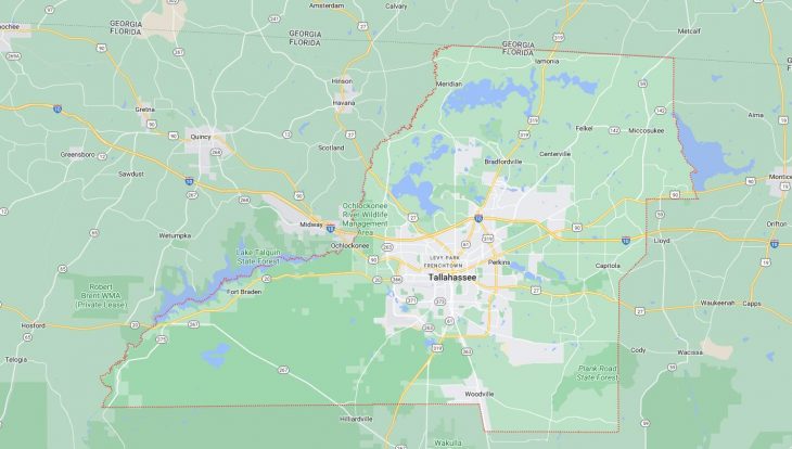
Cities and Towns in Leon County, Florida
Founded in 1824, Leon County is one of 67 counties in the state of Florida. Historically, Leon County was formed from Gadsden. The city of Tallahassee is the county seat. With FIPS code of 73, Leon County has a population of 292,817 and area of 667 square miles (1,728 km²).
List of all cities in Leon County, FL alphabetically
City/Town | Postal Code | Area Code |
Centerville, FL | 32308 | 850 |
32309 | 850 | |
32317 | 850 | |
Fl State Lot, FL | 32395 | 850 |
Fl State University Student, FL | 32313 | 850 |
Florida A and M University, FL | 32307 | 850 |
Florida State Lottery, FL | 32395 | 850 |
Florida State University, FL | 32306 | 850 |
32313 | 850 | |
Florida State University Admin, FL | 32306 | 850 |
Miccosukee, FL | 32309 | 850 |
State of Florida, FL | 32399 | 850 |
Tallahassee, FL | 32301 | 850 |
32302 | 850 | |
32303 | 850 | |
32304 | 850 | |
32305 | 850 | |
32306 | 850 | |
32307 | 850 | |
32308 | 850 | |
32309 | 850 | |
32310 | 850 | |
32311 | 850 | |
32312 | 850 | |
32313 | 850 | |
32314 | 850 | |
32315 | 850 | |
32316 | 850 | |
32317 | 850 | |
32318 | 850 | |
32395 | 850 | |
32399 | 850 | |
Woodville, FL | 32362 | 850 |
Major Cities and Towns in Leon County, Florida
Tallahassee
Area, Population, and Geographic Coordinates
- Area: 103.5 square miles
- Population: Approximately 196,169 (as of 2020)
- Zip Codes: 32301, 32303, 32304, 32308, 32309, 32310, 32311, 32312, 32317
- Latitude: 30.4383° N
- Longitude: 84.2807° W
Location and History
Tallahassee is the capital city of Florida and the largest city in Leon County, located in the Florida Panhandle. The city was established in 1824 as the territorial capital, chosen for its central location between the former capitals of East and West Florida. Tallahassee has a rich history that includes its role as a center of government, education, and commerce in the region. The city played a significant role during the Civil War as the only Confederate capital east of the Mississippi River that was not captured by Union forces. Today, Tallahassee is known for its vibrant culture, historic landmarks, and as a hub for higher education, being home to Florida State University (FSU) and Florida A&M University (FAMU).
Major Schools and Landmarks
Tallahassee is served by the Leon County School District, with notable schools including Leon High School, which is one of the oldest public high schools in the state, and Lincoln High School. In addition to FSU and FAMU, Tallahassee Community College (TCC) offers a range of academic programs and vocational training. Major landmarks in Tallahassee include the Florida State Capitol, a towering structure that houses the offices of the state government, and the historic Mission San Luis, a reconstructed 17th-century Spanish mission. The city is also home to the Museum of Florida History, which provides insights into the state’s past, and Cascades Park, a popular urban park that features walking trails, an amphitheater, and a beautiful fountain. Tallahassee’s combination of historical significance, educational institutions, and cultural attractions makes it the central city in Leon County.
Woodville
Area, Population, and Geographic Coordinates
- Area: 3.2 square miles
- Population: Approximately 3,006 (as of 2020)
- Zip Codes: 32305
- Latitude: 30.2964° N
- Longitude: 84.2524° W
Location and History
Woodville is a small, unincorporated community located south of Tallahassee in Leon County. The community has a long history that dates back to the early 19th century when it served as a crossroads for settlers traveling between Tallahassee and the Gulf Coast. Woodville developed as an agricultural community, with farming and timber being the primary economic activities. The area is known for its rural charm and close-knit community, offering a quieter alternative to the bustling city of Tallahassee while still being close enough to access its amenities. Woodville has maintained its small-town feel, with a focus on preserving its natural surroundings and historical heritage.
Major Schools and Landmarks
Woodville is served by the Leon County School District, with students typically attending schools in nearby Tallahassee, such as Woodville Elementary School. Major landmarks in Woodville include the Woodville Park and Recreation Complex, which offers sports facilities, walking trails, and playgrounds for residents, and the Natural Bridge Battlefield Historic State Park, located a short drive away. The park preserves the site of the Battle of Natural Bridge, where Confederate forces successfully defended Tallahassee from Union troops during the Civil War. The nearby St. Marks National Wildlife Refuge offers opportunities for birdwatching, hiking, and exploring the natural beauty of the Florida Gulf Coast. Woodville’s combination of historical significance, educational institutions, and rural charm makes it an important community in Leon County.
Chaires
Area, Population, and Geographic Coordinates
- Area: 1.8 square miles (approximate, unincorporated community)
- Population: Approximately 1,500 (estimate)
- Zip Codes: 32317
- Latitude: 30.4542° N
- Longitude: 84.1058° W
Location and History
Chaires is a small, unincorporated community located in the eastern part of Leon County, near the city of Tallahassee. The community was named after Benjamin Chaires, a prominent early settler who established a plantation in the area in the early 19th century. Chaires developed as an agricultural community, with cotton and tobacco being the primary crops during its early years. The area has a rich history tied to the antebellum South, with several historic homes and sites still standing today. Over the years, Chaires has remained a small, rural community with a focus on preserving its historical heritage and natural environment.
Major Schools and Landmarks
Chaires is served by the Leon County School District, with Chaires Elementary School being the primary educational institution in the area. Major landmarks in Chaires include the historic Chaires United Methodist Church, which has been a central part of the community since the 19th century, and the nearby Miccosukee Canopy Road Greenway, which offers hiking, biking, and horseback riding trails through scenic oak-lined roads. The community’s annual events, such as the Chaires Elementary Fall Festival, reflect its strong sense of tradition and community pride. The surrounding natural areas, including several lakes and forests, provide a peaceful setting for outdoor recreation. Chaires’ combination of historical significance, educational institutions, and rural charm makes it an important community in Leon County.
Miccosukee
Area, Population, and Geographic Coordinates
- Area: 2.0 square miles (approximate, unincorporated community)
- Population: Approximately 500 (estimate)
- Zip Codes: 32309
- Latitude: 30.6113° N
- Longitude: 84.0055° W
Location and History
Miccosukee is a small, unincorporated community located in the northeastern part of Leon County, near the Georgia border. The community was named after the Miccosukee tribe, part of the Seminole Nation, who inhabited the area before European settlement. Miccosukee developed as an agricultural and trading center during the 19th century, with cotton and timber being the primary industries. The community’s location along the Old Spanish Trail made it an important stop for travelers and traders. Today, Miccosukee is known for its rural charm, historic sites, and strong sense of community. The area is characterized by its rolling hills, oak forests, and scenic beauty, making it a peaceful retreat from the nearby urban areas.
Major Schools and Landmarks
Miccosukee is served by the Leon County School District, with students typically attending schools in nearby Tallahassee. Major landmarks in Miccosukee include the historic Miccosukee United Methodist Church, which has served the community since the 19th century, and the Miccosukee Greenway, a scenic trail that offers opportunities for hiking, biking, and horseback riding through the natural landscapes of the area. The nearby Bradley’s Country Store is a historic landmark and popular destination for locals and visitors, known for its homemade sausage and other Southern delicacies. The community’s annual Miccosukee Day celebrates its history and culture with music, food, and family-friendly activities. Miccosukee’s combination of historical significance, educational institutions, and rural charm makes it an important community in Leon County.
Capitola
Area, Population, and Geographic Coordinates
- Area: 1.5 square miles (approximate, unincorporated community)
- Population: Approximately 200 (estimate)
- Zip Codes: 32317
- Latitude: 30.4417° N
- Longitude: 84.0603° W
Location and History
Capitola is a small, unincorporated community located in the eastern part of Leon County, near the city of Tallahassee. The community was established in the late 19th century and named after the fictional heroine in the novel The Hidden Hand by E.D.E.N. Southworth. Capitola developed as a rural farming community, with agriculture and timber being the primary economic activities. The area is known for its scenic beauty, with rolling hills, forests, and creeks providing a picturesque setting. Capitola has remained a small, close-knit community with a focus on preserving its rural heritage and natural environment.
Major Schools and Landmarks
Capitola is served by the Leon County School District, with students typically attending schools in nearby Tallahassee. Major landmarks in Capitola include the historic Capitola United Methodist Church, which has been a central part of the community since its establishment, and the nearby St. Marks River, which offers opportunities for fishing, boating, and exploring the natural beauty of the area. The community’s annual events, such as the Capitola Christmas Parade, reflect its strong sense of tradition and community pride. The surrounding natural areas, including several state parks and wildlife preserves, provide ample opportunities for outdoor recreation. Capitola’s combination of historical significance, educational institutions, and rural charm makes it an important community in Leon County.