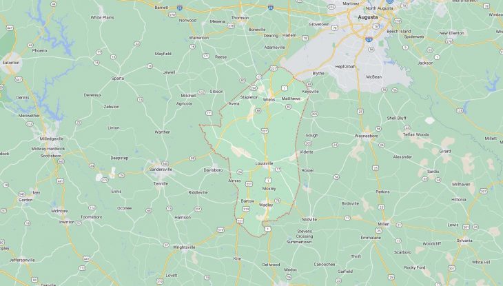
Cities and Towns in Jefferson County, Georgia
Founded in 1796, Jefferson County is one of 159 counties in the state of Georgia. Historically, Jefferson County was formed from Burke and Warren Counties. The city of Louisville is the county seat. With FIPS code of 163, Jefferson County has a population of 15,524 and area of 528 square miles (1,368 km²).
List of all cities in Jefferson County, GA alphabetically
City/Town | Postal Code | Area Code |
Avera, GA | 30803 | 706/762 |
Bartow, GA | 30413 | 478 |
Grange, GA | 30434 | 478 |
Louisville, GA | 30434 | 478 |
Matthews, GA | 30818 | 706/762 |
Moxley, GA | 30477 | 478 |
Noah, GA | 30818 | 706/762 |
Rosier, GA | 30434 | 478 |
Stapleton, GA | 30823 | 706/762 |
Vidette, GA | 30434 | 478 |
Wadley, GA | 30477 | 478 |
Wrens, GA | 30818 | 706/762 |
30833 | 706/762 |
Major Cities and Towns in Jefferson County, Georgia
Louisville
Area, Population, Zip Codes, Latitude and Longitude
- Area: 3.7 square miles
- Population: Approximately 2,300 (as of the 2020 census)
- Zip Codes: 30434
- Latitude and Longitude: 32.9915° N, 82.4037° W
Location and History
Louisville is the county seat and largest city in Jefferson County, Georgia, located in the east-central part of the state. Established in 1786, Louisville served as the state capital of Georgia from 1796 to 1807. The city was named after King Louis XVI of France, reflecting the strong French support for the American Revolution. Louisville’s strategic location on the Ogeechee River made it a key center for trade and government during its early years. The city is home to several historical sites, including the Old Market House, where enslaved people were once sold, and the Jefferson County Courthouse, built in 1904. Louisville has retained much of its historical charm, with a downtown area that features historic buildings and a strong sense of heritage.
Major Schools and Landmarks
Louisville is served by the Jefferson County School District, which includes Jefferson County High School, Louisville Academy, and Louisville Middle School. The city is home to several significant landmarks, including the Old Market House, a National Historic Landmark that stands as a reminder of the city’s past as Georgia’s capital and a major trading post. The Jefferson County Courthouse, with its Classical Revival architecture, is another prominent landmark. Additionally, Louisville is known for the Magnolia Springs State Park, located nearby, which offers recreational opportunities such as camping, fishing, and hiking. Louisville’s blend of historical significance, educational resources, and cultural heritage makes it the heart of Jefferson County.
Wrens
Area, Population, Zip Codes, Latitude and Longitude
- Area: 3.5 square miles
- Population: Approximately 2,100 (as of the 2020 census)
- Zip Codes: 30833
- Latitude and Longitude: 33.2074° N, 82.3932° W
Location and History
Wrens is a city located in Jefferson County, Georgia, approximately 30 miles southwest of Augusta. The city was incorporated in 1901 and named after W.J. Wren, an early settler and prominent businessman in the area. Wrens developed as a small agricultural community, with its economy historically centered around farming, particularly cotton and peanuts. The arrival of the railroad in the late 19th century contributed to the town’s growth, making it a local hub for transportation and trade. Over the years, Wrens has maintained its small-town charm while adapting to modern developments. The city is known for its friendly atmosphere and strong sense of community.
Major Schools and Landmarks
Wrens is served by the Jefferson County School District, with students attending Wrens Middle School, Wrens Elementary School, and Jefferson County High School. The city’s landmarks include the historic Wrens City Hall, which has been a central part of the community since its construction in the early 20th century. The surrounding area offers opportunities for outdoor activities such as hunting, fishing, and exploring the natural beauty of the region. Wrens’s annual events, including local fairs and festivals, highlight the town’s strong sense of tradition and community spirit. Wrens’s historical roots, rural charm, and close-knit community make it an important part of Jefferson County.
Wadley
Area, Population, Zip Codes, Latitude and Longitude
- Area: 3.2 square miles
- Population: Approximately 2,000 (as of the 2020 census)
- Zip Codes: 30477
- Latitude and Longitude: 32.8701° N, 82.4037° W
Location and History
Wadley is a small city located in the southern part of Jefferson County, Georgia. The city was incorporated in 1876 and named after William M. Wadley, the president of the Central of Georgia Railway. Wadley grew as a railroad town, with its economy historically centered around transportation and agriculture. The city’s strategic location along the railway made it a key hub for shipping agricultural products, particularly cotton, to larger markets. Over the years, Wadley has maintained its small-town charm and has a strong sense of community. The city is known for its historic buildings and the preservation of its railway heritage.
Major Schools and Landmarks
Wadley is served by the Jefferson County School District, with students attending Wadley Primary School, Wadley Middle School, and Jefferson County High School. The city’s landmarks include the historic Wadley Depot, which served as a key transportation hub in the late 19th and early 20th centuries. The depot has been preserved as a symbol of the city’s railway heritage. Another notable site is the Wadley Baptist Church, established in the 19th century, which remains a central part of the community. The surrounding area offers opportunities for outdoor activities such as fishing, hunting, and exploring the natural beauty of the region. Wadley’s historical significance, educational resources, and community spirit make it a valued part of Jefferson County.
Bartow
Area, Population, Zip Codes, Latitude and Longitude
- Area: 1.2 square miles
- Population: Approximately 200 (as of the 2020 census)
- Zip Codes: 30413
- Latitude and Longitude: 32.8821° N, 82.4726° W
Location and History
Bartow is a small town located in Jefferson County, Georgia, near the western edge of the county. The town was incorporated in 1872 and named after Francis S. Bartow, a Confederate general from Georgia. Bartow developed as a rural farming community, with its economy traditionally centered around agriculture, particularly cotton and timber. The town’s growth was modest, and it has remained a small, quiet community throughout its history. Despite its size, Bartow has a rich history and has preserved much of its rural character and Southern charm.
Major Schools and Landmarks
Bartow is served by the Jefferson County School District, with students attending schools in nearby Louisville, including Jefferson County High School. The town’s landmarks include several historic churches and homes that reflect its agricultural heritage and rural way of life. The surrounding countryside offers opportunities for outdoor activities such as hunting, fishing, and exploring the natural beauty of the area. Bartow’s annual events, including local fairs and community gatherings, highlight the town’s strong sense of tradition and community spirit. Bartow’s historical roots, rural charm, and close-knit community make it a valued part of Jefferson County.
Avera
Area, Population, Zip Codes, Latitude and Longitude
- Area: 0.8 square miles
- Population: Approximately 250 (as of the 2020 census)
- Zip Codes: 30803
- Latitude and Longitude: 33.2041° N, 82.5288° W
Location and History
Avera is a small town located in Jefferson County, Georgia, in the northern part of the county. The town was incorporated in 1906 and named after the Avera family, who were early settlers in the area. Avera developed as a rural community with a focus on agriculture, particularly cotton farming. The town’s growth was modest, and it has remained a small, close-knit community with a strong emphasis on farming and family life. Despite its small size, Avera has a rich history and has retained much of its rural charm and community spirit.
Major Schools and Landmarks
Avera is served by the Jefferson County School District, with students attending schools in Wrens and Louisville, such as Jefferson County High School. The town’s landmarks include several historic churches and old farmhouses that reflect its agricultural heritage. The surrounding area offers opportunities for outdoor activities such as hunting, fishing, and exploring the natural landscapes of the region. Avera’s annual events, including local church gatherings and community fairs, highlight the town’s strong sense of tradition and close-knit community spirit. Avera’s rural charm, historical significance, and connection to the land make it an important part of Jefferson County.