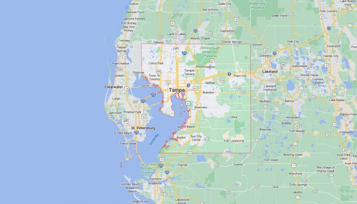
Cities and Towns in Hillsborough County, Florida
Founded in 1834, Hillsborough County is one of 67 counties in the state of Florida. Historically, Hillsborough County was formed from Alachua. The city of Tampa is the county seat. With FIPS code of 57, Hillsborough County has a population of 1,478,194 and area of 1,051 square miles (2,722 km²).
List of all cities in Hillsborough County, FL alphabetically
City/Town | Postal Code | Area Code |
Apollo Beach, FL | 33572 | 813 |
Balm, FL | 33503 | 813 |
Brandon, FL | 33508 | 813 |
33509 | 813 | |
33510 | 813 | |
33511 | 813 | |
Business Reply, FL | 33633 | 813 |
Carrollwood, FL | 33618 | 813 |
33625 | 813 | |
33688 | 813 | |
Clair Mel, FL | 33619 | 813 |
Dover, FL | 33527 | 813 |
Durant, FL | 33530 | 813 |
Gibsonton, FL | 33534 | 813 |
Home Shopping Club, FL | 33650 | 813 |
Lithia, FL | 33547 | 813 |
Lutz, FL | 33548 | 813 |
33549 | 813 | |
33558 | 813 | |
33559 | 813 | |
Macdill AFB, FL | 33608 | 813 |
Mango, FL | 33550 | 813 |
Nations Bank, FL | 33655 | 813 |
Northdale, FL | 33624 | 813 |
33626 | 813 | |
Odessa, FL | 33556 | 813 |
Palma Ceia, FL | 33629 | 813 |
33690 | 813 | |
Plant City, FL | 33563 | 813 |
33564 | 813 | |
33565 | 813 | |
33566 | 813 | |
33567 | 813 | |
Riverview, FL | 33568 | 813 |
33569 | 813 | |
33578 | 352 | |
33579 | 352 | |
Ruskin, FL | 33570 | 813 |
33571 | 813 | |
33572 | 813 | |
33573 | 813 | |
33575 | 813 | |
Seffner, FL | 33583 | 813 |
33584 | 813 | |
Sun City, FL | 33586 | 813 |
Sun City Center, FL | 33570 | 813 |
33571 | 813 | |
33573 | 813 | |
33575 | 813 | |
Sydney, FL | 33587 | 813 |
Tampa, FL | 33601 | 813 |
33602 | 813 | |
33603 | 813 | |
33604 | 813 | |
33605 | 813 | |
33606 | 813 | |
33607 | 813 | |
33608 | 813 | |
33609 | 813 | |
33610 | 813 | |
33611 | 813 | |
33612 | 813 | |
33613 | 813 | |
33614 | 813 | |
33615 | 813 | |
33616 | 813 | |
33617 | 813 | |
33618 | 813 | |
33619 | 813 | |
33620 | 813 | |
33621 | 813 | |
33622 | 813 | |
33623 | 813 | |
33624 | 813 | |
33625 | 813 | |
33626 | 813 | |
33629 | 813 | |
33630 | 813 | |
33631 | 813 | |
33633 | 813 | |
33634 | 813 | |
33635 | 813 | |
33637 | 813 | |
33646 | 813 | |
33647 | 813 | |
33650 | 813 | |
33655 | 813 | |
33660 | 813 | |
33661 | 813 | |
33662 | 813 | |
33663 | 813 | |
33664 | 813 | |
33672 | 813 | |
33673 | 813 | |
33674 | 813 | |
33675 | 813 | |
33677 | 813 | |
33679 | 813 | |
33680 | 813 | |
33681 | 813 | |
33682 | 813 | |
33684 | 813 | |
33685 | 813 | |
33686 | 813 | |
33687 | 813 | |
33688 | 813 | |
33689 | 813 | |
33690 | 813 | |
33694 | 813 | |
Tampa Brm Unique, FL | 33633 | 813 |
Tampa Palms, FL | 33647 | 813 |
Temple Terrace, FL | 33617 | 813 |
33637 | 813 | |
33687 | 813 | |
Thonotosassa, FL | 33592 | 813 |
Time Cs Brm Unique, FL | 33634 | 813 |
33664 | 813 | |
Time Customer Service Inc, FL | 33664 | 813 |
Time Inc, FL | 33660 | 813 |
33661 | 813 | |
33662 | 813 | |
33664 | 813 | |
Town N Country, FL | 33615 | 813 |
Twn N Cntry, FL | 33615 | 813 |
University of South Florida, FL | 33620 | 813 |
University of Tampa, FL | 33606 | 813 |
Valrico, FL | 33594 | 813 |
33595 | 813 | |
33596 | 813 | |
Westchase, FL | 33626 | 813 |
Wimauma, FL | 33598 | 813 |
Ybor City, FL | 33605 | 813 |
33675 | 813 |
Major Cities and Towns in Hillsborough County, Florida
Tampa
Area, Population, Zip Codes, and Coordinates
- Area: 175.3 square miles
- Population: Approximately 407,000 (2023 estimate)
- Zip Codes: 33601-33626, 33629-33631, 33646-33647, 33650-33651, 33655, 33660-33664, 33672-33675, 33677, 33679-33682, 33684-33690, 33694
- Latitude and Longitude: 27.9506° N, 82.4572° W
Location and History
Tampa, the largest city in Hillsborough County and the third-largest in Florida, is located on the west coast of the state, along the Gulf of Mexico. Founded in 1824, Tampa’s early history was shaped by its strategic location at the mouth of the Hillsborough River, which made it an ideal port city. The city grew rapidly during the 19th century, particularly after the construction of Fort Brooke and the arrival of the railroad, which connected Tampa to the rest of the country. The cigar industry, established by Vicente Martinez-Ybor in the late 1800s, further fueled Tampa’s growth, leading to the development of Ybor City, a historic neighborhood known for its rich cultural heritage. Today, Tampa is a vibrant metropolitan area known for its diverse economy, cultural attractions, and thriving waterfront district.
Major Schools and Landmarks
Tampa is served by Hillsborough County Public Schools, the eighth-largest school district in the United States, with notable institutions such as Plant High School and Robinson High School. Tampa is also home to the University of South Florida, a major public research university. Major landmarks include the historic Ybor City, the Tampa Riverwalk, and the Tampa Bay History Center. The city also boasts a range of cultural institutions, including the Tampa Museum of Art and the Straz Center for the Performing Arts. Busch Gardens Tampa Bay, a popular theme park and zoo, is another key attraction. Tampa’s blend of history, culture, and modern amenities make it a dynamic and thriving city in Hillsborough County.
Plant City
Area, Population, Zip Codes, and Coordinates
- Area: 28.1 square miles
- Population: Approximately 40,000 (2023 estimate)
- Zip Codes: 33563-33567
- Latitude and Longitude: 28.0186° N, 82.1129° W
Location and History
Plant City, located in the eastern part of Hillsborough County, is often referred to as the “Winter Strawberry Capital of the World.” The town was founded in 1885 and named after railroad tycoon Henry B. Plant, whose railroad significantly contributed to the town’s growth by connecting it to major markets. Plant City developed as an agricultural hub, with strawberries becoming its most famous crop, leading to the annual Florida Strawberry Festival, a major event that attracts visitors from all over the state. Despite its growth, Plant City has retained much of its small-town charm, with a historic downtown area that reflects its rich heritage.
Major Schools and Landmarks
Plant City is served by Hillsborough County Public Schools, with notable schools such as Plant City High School and Tomlin Middle School. Major landmarks include the historic downtown district, which features the Plant City Train Depot and the Bing Rooming House Museum, a significant site in African American history. The Edward Medard Park and Reservoir, offering hiking, fishing, and camping, is a popular outdoor destination. The Florida Strawberry Festival, held annually in the spring, is Plant City’s signature event, celebrating the town’s agricultural roots with entertainment, food, and cultural exhibits. Plant City’s combination of agricultural heritage, historic charm, and community spirit make it a unique and important city within Hillsborough County.
Temple Terrace
Area, Population, Zip Codes, and Coordinates
- Area: 7.3 square miles
- Population: Approximately 26,000 (2023 estimate)
- Zip Codes: 33617, 33637, 33687
- Latitude and Longitude: 28.0353° N, 82.3893° W
Location and History
Temple Terrace is a city located northeast of Tampa, along the Hillsborough River. The city was founded in the 1920s as a planned golf course community, with its name derived from the Temple orange, a popular variety of orange grown in the area, and the terraced terrain along the river. Temple Terrace was initially developed as an exclusive winter retreat for wealthy northerners, with a Mediterranean Revival architectural style that remains a hallmark of the city. Over the years, Temple Terrace has grown into a residential suburb of Tampa, known for its tree-lined streets, parks, and strong sense of community.
Major Schools and Landmarks
Temple Terrace is served by Hillsborough County Public Schools, with schools such as King High School and Greco Middle School being key educational institutions. Major landmarks in Temple Terrace include the historic Temple Terrace Golf and Country Club, which is listed on the National Register of Historic Places, and the Temple Terrace Preservation Society, which works to maintain the city’s historic character. The city also boasts several parks, including Riverhills Park, which offers river access, playgrounds, and nature trails. The annual Temple Terrace Craft BrewFest and the 4th of July Parade are popular community events. Temple Terrace’s combination of historic charm, green spaces, and community-focused living make it a desirable residential area within Hillsborough County.
Brandon
Area, Population, Zip Codes, and Coordinates
- Area: 35.0 square miles
- Population: Approximately 120,000 (2023 estimate)
- Zip Codes: 33510-33511
- Latitude and Longitude: 27.9378° N, 82.2859° W
Location and History
Brandon is a large unincorporated community located to the east of Tampa, within Hillsborough County. The town was founded in the late 19th century by John Brandon, who established the community after acquiring land in the area. Brandon remained a small, rural community until the mid-20th century, when the construction of Interstate 75 and the growth of Tampa spurred significant suburban development. Today, Brandon is one of the largest and most populous suburbs in the Tampa Bay area, offering a mix of residential neighborhoods, shopping centers, and commercial areas. Despite its rapid growth, Brandon has retained a strong sense of community and is known for its family-friendly atmosphere.
Major Schools and Landmarks
Brandon is served by Hillsborough County Public Schools, with notable schools such as Brandon High School and Burns Middle School. Major landmarks in Brandon include the Westfield Brandon Mall, a major shopping destination in the area, and the Brandon Regional Hospital, a key healthcare facility serving the community. The town also features several parks, including Brandon Park and Recreation Center, which offers sports facilities, playgrounds, and community events. The annual Brandon Balloon Glow, where hot air balloons light up the night sky, is a popular event that draws visitors from across the region. Brandon’s combination of suburban amenities, strong schools, and community events make it a vibrant and attractive place to live in Hillsborough County.
Riverview
Area, Population, Zip Codes, and Coordinates
- Area: 48.3 square miles
- Population: Approximately 100,000 (2023 estimate)
- Zip Codes: 33569, 33578-33579
- Latitude and Longitude: 27.8661° N, 82.3265° W
Location and History
Riverview is a rapidly growing unincorporated community located south of Brandon, along the eastern banks of the Alafia River. The area was first settled in the mid-19th century and developed as a small farming and fishing community. The name “Riverview” reflects its location along the river, which played a central role in the community’s early development. In recent decades, Riverview has experienced significant growth as a suburban area, attracting new residents with its proximity to Tampa, affordable housing, and access to natural amenities. The community has seen substantial residential and commercial development, transforming it into one of the fastest-growing areas in Hillsborough County.
Major Schools and Landmarks
Riverview is served by Hillsborough County Public Schools, with schools such as Riverview High School and Spoto High School serving the community. Major landmarks in Riverview include the Alafia River State Park, which offers a range of outdoor activities, including mountain biking, hiking, and horseback riding. The Riverview Civic Center, located along the river, is a key venue for community events and gatherings. The nearby Bell Creek Nature Preserve provides additional opportunities for outdoor recreation and wildlife observation. Riverview’s combination of suburban growth, natural beauty, and community amenities make it a highly desirable place to live within Hillsborough County.
Valrico
Area, Population, Zip Codes, and Coordinates
- Area: 14.0 square miles
- Population: Approximately 40,000 (2023 estimate)
- Zip Codes: 33594, 33596
- Latitude and Longitude: 27.9375° N, 82.2366° W
Location and History
Valrico is an unincorporated community located to the east of Brandon in Hillsborough County. The area was originally known as Long Pond, a rural area with few settlers until the arrival of the railroad in the late 19th century, which spurred development. The name “Valrico” is derived from the Spanish term meaning “rich valley,” reflecting the area’s fertile soil and agricultural potential. Valrico grew slowly throughout the early 20th century, primarily as an agricultural community, but like many areas in Hillsborough County, it saw rapid growth in the post-World War II era as suburban development expanded outward from Tampa. Today, Valrico is a suburban community known for its family-friendly neighborhoods, schools, and parks.
Major Schools and Landmarks
Valrico is served by Hillsborough County Public Schools, with schools such as Bloomingdale High School and Mulrennan Middle School being prominent educational institutions. Major landmarks in Valrico include the Valrico Lake, which offers opportunities for fishing and boating, and the Buckhorn Springs Golf and Country Club, a popular recreational facility for residents. The area is also home to several parks, including Lithia Springs Park, known for its natural spring and outdoor activities. The annual Bloomingdale Fall Festival, held in nearby Bloomingdale, is a popular event for Valrico residents, featuring local crafts, food, and entertainment. Valrico’s suburban character, strong schools, and access to recreational amenities make it an appealing place to live within Hillsborough County.