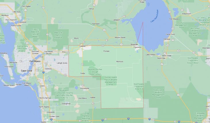
Cities and Towns in Hendry County, Florida

Founded in 1923, Hendry County is one of 67 counties in the state of Florida. Historically, Hendry County was formed from Lee. The city of LaBelle is the county seat. With FIPS code of 51, Hendry County has a population of 40,313 and area of 1,153 square miles (2,986 km²).

List of all cities in Hendry County, FL alphabetically

City/Town Postal Code Area Code
Clewiston, FL 33440 863
Felda, FL 33930 863
Fort Denaud, FL 33935 863
Labelle, FL 33935 863
33975 863

Major Cities and Towns in Hendry County, Florida

Clewiston

Area, Population, Zip Codes, and Coordinates

  • Area: 5.1 square miles
  • Population: Approximately 7,500 (2023 estimate)
  • Zip Codes: 33440
  • Latitude and Longitude: 26.7547° N, 80.9331° W

Location and History

Clewiston, often referred to as “America’s Sweetest Town,” is the largest city in Hendry County, located on the southwestern shore of Lake Okeechobee. The town was established in the 1920s as a planned community by the United States Sugar Corporation, which sought to develop a sugarcane industry in South Florida. Clewiston quickly became the center of the region’s sugar production, and its economy has long been dominated by agriculture, particularly sugarcane farming and processing. The city’s location on Lake Okeechobee has also made it a popular destination for fishing, boating, and other water-based recreation. Over the years, Clewiston has maintained its small-town charm while continuing to be a key player in Florida’s agricultural industry.

Major Schools and Landmarks

Clewiston is served by the Hendry County School District, with Clewiston High School and Clewiston Middle School being the primary educational institutions. Major landmarks in Clewiston include the Clewiston Museum, which offers exhibits on the history of the town and the sugar industry, and the historic Clewiston Inn, a charming hotel built in the 1930s that reflects the city’s early development. The nearby Roland and Mary Ann Martin’s Marina is a renowned destination for fishing enthusiasts, particularly those seeking to catch trophy-sized largemouth bass on Lake Okeechobee. The annual Sugar Festival, celebrating the town’s agricultural heritage, is one of the most anticipated events in Clewiston, attracting visitors from across the region. Clewiston’s rich history, connection to agriculture, and proximity to Lake Okeechobee make it a vibrant and essential community in Hendry County.

LaBelle

Area, Population, Zip Codes, and Coordinates

  • Area: 15.6 square miles
  • Population: Approximately 5,500 (2023 estimate)
  • Zip Codes: 33935, 33975
  • Latitude and Longitude: 26.7612° N, 81.4395° W

Location and History

LaBelle, the county seat of Hendry County, is located along the Caloosahatchee River in the northern part of the county. The town was founded in the late 19th century and was named after Laura and Belle Hendry, the daughters of Francis Asbury Hendry, a prominent Florida cattleman and the county’s namesake. LaBelle developed as an agricultural community, with cattle ranching, citrus farming, and later, sugarcane production playing key roles in its economy. The town’s location along the Caloosahatchee River also made it an important transportation hub in the early 20th century. Today, LaBelle is known for its scenic beauty, historic charm, and its role as the administrative center of Hendry County.

Major Schools and Landmarks

LaBelle is served by the Hendry County School District, with LaBelle High School and LaBelle Middle School being the main educational institutions. Major landmarks in LaBelle include the LaBelle Heritage Museum, which preserves the history of the town and the surrounding region, and the historic Captain Hendry House, a beautifully restored home that reflects the town’s early days. The nearby Caloosahatchee River offers opportunities for boating, fishing, and scenic river cruises. The town is also known for its annual Swamp Cabbage Festival, a celebration of Florida’s pioneer heritage and local culture. LaBelle’s combination of history, community events, and natural beauty make it a charming and welcoming city in Hendry County.

Moore Haven

Area, Population, Zip Codes, and Coordinates

  • Area: 1.1 square miles
  • Population: Approximately 1,800 (2023 estimate)
  • Zip Codes: 33471
  • Latitude and Longitude: 26.8337° N, 81.0931° W

Location and History

Moore Haven, though geographically located in Glades County, often serves as a key community for residents in eastern Hendry County due to its proximity to the county line and its location on the southwest shore of Lake Okeechobee. The town was founded in 1915 by James A. Moore, a real estate developer who envisioned it as a future commercial hub. Early in its history, Moore Haven became known as the “Little Chicago of the South” due to its bustling port and transportation links via the Lake Okeechobee Waterway. However, the town faced significant challenges, including devastating hurricanes in the 1920s, which shaped its development. Despite these setbacks, Moore Haven has remained a close-knit community, known for its fishing and access to Lake Okeechobee.

Major Schools and Landmarks

Moore Haven is served by the Glades County School District, with Moore Haven Middle-High School being the primary educational institution. Major landmarks include the Moore Haven Lock and Dam, which regulates water levels in Lake Okeechobee and is a popular spot for fishing and observing the flow of water between the lake and the Caloosahatchee River. The town’s historic downtown area, with its small shops and restaurants, reflects its past as a bustling port community. The nearby Fisheating Creek Wildlife Management Area offers opportunities for canoeing, wildlife viewing, and exploring the natural beauty of the region. Moore Haven’s rich history, connection to Lake Okeechobee, and rural charm make it a significant and enduring community in the broader area, including parts of Hendry County.

Map of Cities in Hendry County, FL

Map of Cities in Hendry County, FL