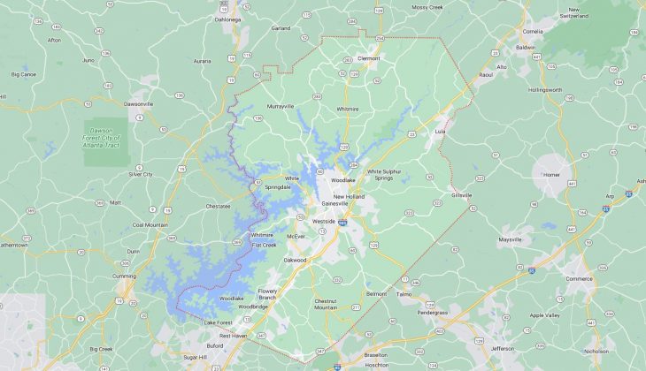
Cities and Towns in Hall County, Georgia
Founded in 1818, Hall County is one of 159 counties in the state of Georgia. Historically, Hall County was formed from Cherokee Cessions of 1817 and 1819. The city of Gainesville is the county seat. With FIPS code of 139, Hall County has a population of 207,369 and area of 394 square miles (1,020 km²).
List of all cities in Hall County, GA alphabetically
City/Town | Postal Code | Area Code |
Chestnut Mountain, GA | 30502 | 770/678/470 |
Clermont, GA | 30527 | 770/678/470 |
Flowery Branch, GA | 30542 | 770/678/470 |
Gainesville, GA | 30501 | 770/678/470 |
30503 | 770/678/470 | |
30504 | 770/678/470 | |
30506 | 770/678/470 | |
30507 | 770/678/470 | |
Gillsville, GA | 30543 | 770/678/470 |
Lula, GA | 30554 | 770/678/470 |
Murrayville, GA | 30564 | 770/678/470 |
Oakwood, GA | 30502 | 770/678/470 |
30566 | 770/678/470 | |
Westside, GA | 30501 | 770/678/470 |
Major Cities and Towns in Hall County, Georgia
Gainesville
Area, Population, Zip Codes, Latitude, and Longitude
- Area: 34.6 square miles
- Population: 43,232 (as of the 2020 census)
- Zip Codes: 30501, 30503, 30504, 30506, 30507
- Latitude: 34.2979° N
- Longitude: 83.8241° W
Location and History
Gainesville is the county seat of Hall County, located in the northeastern part of Georgia. Founded in 1821 and named after General Edmund P. Gaines, a hero of the War of 1812, Gainesville quickly became a center for trade and industry due to its strategic location in the foothills of the Blue Ridge Mountains and its proximity to the Chattahoochee River. Known as the “Poultry Capital of the World,” Gainesville’s economy has long been dominated by the poultry industry, with numerous processing plants and related businesses operating in the area. Over the years, Gainesville has grown into a vibrant city with a mix of historic charm and modern amenities. The city is also known for its resilience, having rebuilt after a devastating tornado in 1936 that destroyed much of the downtown area. Today, Gainesville is a thriving regional hub for education, healthcare, and commerce.
Major Schools and Landmarks
Gainesville is served by the Gainesville City School District, which includes Gainesville High School, known for its strong academic and athletic programs. The city is also home to Brenau University, a private university offering undergraduate and graduate degrees. Major landmarks in Gainesville include the Northeast Georgia History Center, which offers exhibits on the region’s history, and the Quinlan Visual Arts Center, which hosts art exhibitions and educational programs. The downtown square is a focal point of the city, featuring historic buildings, shops, and restaurants. Additionally, Lake Lanier, a large reservoir created by Buford Dam, is a major recreational destination offering boating, fishing, and water sports.
Flowery Branch
Area, Population, Zip Codes, Latitude, and Longitude
- Area: 7.0 square miles
- Population: 9,391 (as of the 2020 census)
- Zip Codes: 30542
- Latitude: 34.1854° N
- Longitude: 83.9257° W
Location and History
Flowery Branch is a city located in the southern part of Hall County, near the eastern shore of Lake Lanier. Established in 1874, the city’s name is thought to derive from the Cherokee word “Anaguluskee,” meaning “flowers on the branch.” Flowery Branch originally developed as a railroad town, with the arrival of the Atlanta and Richmond Air-Line Railway boosting its growth. The city became a small but important hub for agriculture and trade in the late 19th and early 20th centuries. In recent decades, Flowery Branch has experienced significant growth, transforming from a quiet, rural community into a suburban city with a mix of residential, commercial, and recreational developments. The city is also known as the home of the Atlanta Falcons’ training facility, which has brought national attention to the area.
Major Schools and Landmarks
Flowery Branch is part of the Hall County School District, with Flowery Branch High School and Spout Springs Elementary School being key educational institutions. The city’s historic downtown area, with its preserved 19th-century buildings, is a major landmark and a center for community events and activities. Another significant site is the Flowery Branch Depot, a restored train depot that now serves as a museum and community center. The nearby Lake Lanier offers numerous recreational opportunities, including boating, fishing, and hiking, making it a popular destination for both residents and visitors. Additionally, the city hosts an annual Flowery Branch Car Show, which draws car enthusiasts from across the region.
Oakwood
Area, Population, Zip Codes, Latitude, and Longitude
- Area: 5.3 square miles
- Population: 4,822 (as of the 2020 census)
- Zip Codes: 30566
- Latitude: 34.2276° N
- Longitude: 83.8845° W
Location and History
Oakwood is a city located in the southwestern part of Hall County, along the I-985 corridor. Founded in 1896, Oakwood was initially a small agricultural community, with its economy largely based on farming and trade. The city’s growth accelerated in the mid-20th century with the development of the poultry industry in the region, which attracted businesses and workers to the area. Oakwood’s strategic location near major highways and its proximity to Gainesville and Atlanta have made it an attractive location for both residential and industrial development. In recent years, Oakwood has seen significant growth, with new housing developments, commercial centers, and educational institutions contributing to its transformation into a thriving suburban city.
Major Schools and Landmarks
Oakwood is served by both the Hall County School District and the University System of Georgia. Major educational institutions include Johnson High School and the University of North Georgia’s Gainesville campus, which offers a wide range of undergraduate and graduate programs. Significant landmarks in Oakwood include the Chicopee Woods Nature Preserve, a large protected area offering hiking trails and educational programs focused on environmental conservation. The city is also home to the Gainesville-Oakwood Industrial Park, a key economic driver for the region. Oakwood’s annual events, such as the Oakwood Secret Santa Car Show, contribute to the city’s strong sense of community and tradition.
Lula
Area, Population, Zip Codes, Latitude, and Longitude
- Area: 4.3 square miles
- Population: 3,126 (as of the 2020 census)
- Zip Codes: 30554
- Latitude: 34.3879° N
- Longitude: 83.6641° W
Location and History
Lula is a small city located in the northeastern part of Hall County, near the border with Banks County. The city was established in the late 19th century, primarily as a railroad town, with the intersection of two major rail lines— the Atlanta and Charlotte Air Line Railway and the Gainesville and Northwestern Railroad—playing a crucial role in its development. Lula quickly became a key transportation hub, serving as a shipping point for agricultural products from the surrounding rural areas. The town was named after Lula Phinizy, the daughter of a prominent local railroad official. Over the years, Lula has maintained its small-town character, with a focus on community and tradition. The city’s location near the foothills of the Appalachian Mountains adds to its scenic appeal.
Major Schools and Landmarks
Lula is part of the Hall County School District, with students attending Lula Elementary School and East Hall High School. The city’s most notable landmarks include the Lula Railroad Depot, a historic building that has been restored and now serves as a museum and event space. Another key site is the Lula-Belton Historical Society, which preserves the history and heritage of the area. The nearby Chattahoochee National Forest offers ample opportunities for outdoor recreation, including hiking, camping, and fishing. Lula also hosts the annual Lula Railroad Days Festival, a popular event that celebrates the city’s rich railroad history with parades, music, and family-friendly activities.
Clermont
Area, Population, Zip Codes, Latitude, and Longitude
- Area: 3.2 square miles
- Population: 1,049 (as of the 2020 census)
- Zip Codes: 30527
- Latitude: 34.4773° N
- Longitude: 83.7735° W
Location and History
Clermont is a small town located in the northern part of Hall County, near the Blue Ridge Mountains. The town was incorporated in 1913 and was originally known as “Dip,” likely due to its location in a low-lying area surrounded by hills. The name was later changed to Clermont, reflecting a more refined image. Clermont has always been a small, close-knit community with a focus on agriculture, particularly poultry farming and cattle ranching. The town has retained much of its rural character, with large tracts of farmland and scenic landscapes defining the area. Clermont’s history is closely tied to the agricultural development of Hall County, and it remains a quiet, residential community with deep roots in tradition.
Major Schools and Landmarks
Clermont is served by the Hall County School District, with students attending Wauka Mountain Elementary School and North Hall High School. The town’s landmarks include the Clermont Historical Society, which operates a museum showcasing the history and culture of the area. Another significant site is the Clermont Days Festival Grounds, where the town hosts its annual Clermont Days Festival, a two-day event featuring parades, crafts, music, and local food. The surrounding countryside offers opportunities for outdoor activities such as hiking, fishing, and horseback riding, particularly in the nearby Wauka Mountain Range. Clermont’s small-town charm, combined with its rich history and natural beauty, makes it a unique and appealing place to live or visit.