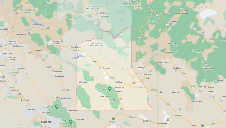
Cities and Towns in Graham County, Arizona

Founded in 1881, Graham County is one of 15 counties in the state of Arizona. Historically, Graham County was formed from Apache and Pima Counties. The city of Safford is the county seat. With FIPS code of 9, Graham County has a population of 39,050 and area of 4,641 square miles (12,020 km²).

List of all cities in Graham County, AZ alphabetically

City/Town Postal Code Area Code
Bylas, AZ 85530 928
Central, AZ 85531 928
Eden, AZ 85535 928
85543 928
Fort Thomas, AZ 85536 928
Pima, AZ 85535 928
85543 928
Safford, AZ 85546 928
85548 928
Solomon, AZ 85551 928
Thatcher, AZ 85552 928

Major Cities and Towns in Graham County, Arizona

Safford

  • Area: 6.9 square miles
  • Population: 10,400 (as of the 2020 Census)
  • Zip Codes: 85546
  • Latitude and Longitude: 32.8334° N, 109.7014° W

Location and History

Safford, the largest city in Graham County, is situated in the southeastern part of Arizona, nestled in the Gila Valley. Established in 1881, Safford was named after the prominent mining engineer and pioneer, J. H. Safford. The city’s development was significantly influenced by the surrounding agricultural and mining activities, including the establishment of cotton and grain farms. Safford’s location along the Gila River provided crucial resources for agriculture and settlement. The city played a key role in the region’s economic growth, driven by both farming and later, by the copper industry in nearby areas. Over time, Safford has evolved into a vital regional center for commerce, education, and services.

Major Schools and Landmarks

Safford is served by the Safford Unified School District, with notable institutions including Safford High School and Safford Middle School. Major landmarks in Safford include the Eastern Arizona College, a prominent educational institution providing higher education opportunities. The city also features the Graham County Historical Society Museum, which offers insights into the local history and heritage of the area. Safford’s vibrant downtown area, with its historical buildings and local businesses, contributes to its community character. The nearby Pinaleño Mountains provide opportunities for outdoor recreation, enhancing the area’s appeal for residents and visitors alike.

Thatcher

  • Area: 2.5 square miles
  • Population: 5,000 (as of the 2020 Census)
  • Zip Codes: 85552
  • Latitude and Longitude: 32.8269° N, 109.7432° W

Location and History

Thatcher, located just north of Safford in Graham County, was originally settled in the late 1800s and named after the Thatcher family, early settlers in the region. The town’s development was closely tied to the agricultural expansion in the Gila Valley, with settlers cultivating crops and establishing farms. Thatcher’s proximity to Safford and its location within the fertile Gila Valley made it an important agricultural community. Over the years, Thatcher has grown into a residential and educational hub, with its community centered around local schools and family life. Its historical roots are reflected in its well-preserved architecture and local traditions.

Major Schools and Landmarks

Thatcher is home to the Thatcher Unified School District, which includes Thatcher High School and Thatcher Middle School. Notable landmarks in the town include the Thatcher Community Park, which offers recreational facilities for local residents. The town’s historical charm is evident in its preserved buildings and community events that celebrate its heritage. Nearby, the Gila Box Riparian National Conservation Area provides opportunities for outdoor activities and exploration, adding to Thatcher’s appeal as a place to live and visit. The town’s focus on education and community well-being highlights its importance within Graham County.

Pima

  • Area: 1.2 square miles
  • Population: 1,900 (as of the 2020 Census)
  • Zip Codes: 85543
  • Latitude and Longitude: 32.7712° N, 109.6615° W

Location and History

Pima is a small town located to the west of Safford in Graham County, Arizona. Established in the early 1900s, Pima’s growth was fueled by agricultural activities in the surrounding area, particularly in cotton and grain farming. The town is named after the Pima Native American tribe, who historically inhabited the region. Pima’s location in the Gila Valley made it an ideal location for farming and ranching, contributing to its development as a close-knit agricultural community. The town’s historical significance is reflected in its farming heritage and its role in the local agricultural economy.

Major Schools and Landmarks

Pima is served by the Pima Unified School District, which includes Pima High School and Pima Junior High School. Key landmarks in Pima include the town’s historical buildings and the local Pima Community Center, which serves as a hub for community activities and events. The nearby Mount Graham provides recreational opportunities, including hiking and outdoor exploration. Pima’s historical charm, combined with its focus on education and community engagement, makes it a distinctive and integral part of Graham County. The town’s agricultural roots and scenic location add to its appeal as a rural community in Arizona.

Map of Cities in Graham County, AZ

Map of Cities in Graham County, AZ