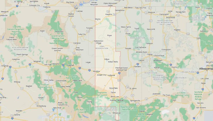
Cities and Towns in Navajo County, Arizona

Founded in 1895, Navajo County is one of 15 counties in the state of Arizona. Historically, Navajo County was formed from Apache County. The city of Holbrook is the county seat. With FIPS code of 17, Navajo County has a population of 108,147 and area of 9,959 square miles (25,794 km²).

List of all cities in Navajo County, AZ alphabetically

City/Town Postal Code Area Code
Baby Rock, AZ 86033 928
Bacobi, AZ 86030 928
Bitahochee, AZ 86031 928
Black Mesa, AZ 86033 928
Blue Gap, AZ 86520 928
Chilchinbito, AZ 86033 928
Cibecue, AZ 85911 928
Clay Springs, AZ 85923 928
Dennebito, AZ 86039 928
Dilkon, AZ 86047 928
First Mesa, AZ 86042 928
Fort Apache, AZ 85926 928
Hano, AZ 86042 928
Hard Rock, AZ 86039 928
Heber, AZ 85928 928
Holbrook, AZ 86025 928
86029 928
86031 928
Hopi Indian Reservation, AZ 86039 928
Hotevilla, AZ 86030 928
Indian Wells, AZ 86031 928
Jeddito, AZ 86034 928
Joseph City, AZ 86032 928
Kayenta, AZ 86033 928
Keams Canyon, AZ 86034 928
Kykotsmovi, AZ 86039 928
Kykotsmovi Village, AZ 86039 928
Lakeside, AZ 85929 928
Leupp Corner, AZ 86047 928
Mishongnovi, AZ 86043 928
New Oraibi, AZ 86039 928
Old Oraibi, AZ 86039 928
Oljato, AZ 86033 928
Oraibi, AZ 86039 928
Overgaard, AZ 85933 928
Pinedale, AZ 85934 928
Pinetop, AZ 85935 928
Pinon, AZ 86510 928
86520 928
Polacca, AZ 86042 928
Sand Springs, AZ 86039 928
Second Mesa, AZ 86043 928
Shipolovi, AZ 86043 928
Shongopovi, AZ 86043 928
Shonto, AZ 86054 928
Show Low, AZ 85901 928
85902 928
85911 928
Shumway, AZ 85901 928
Sichomovi, AZ 86042 928
Snowflake, AZ 85937 928
85942 928
Sun Valley, AZ 86029 928
Taylor, AZ 85939 928
Tolani, AZ 86047 928
Tolani Lakes, AZ 86047 928
Tonalea, AZ 86054 928
Toreva, AZ 86043 928
Walpi, AZ 86042 928
White Mountain Lake, AZ 85912 928
Whiteriver, AZ 85941 928
Winslow, AZ 86047 928
Woodruff, AZ 85942 928

Major Cities and Towns in Navajo County, Arizona

Holbrook

  • Area: 17.4 square miles
  • Population: 4,858 (as of the 2020 Census)
  • Zip Codes: 86025
  • Latitude and Longitude: 34.9022° N, 110.1580° W

Location and History

Holbrook is the county seat of Navajo County, located along the historic Route 66 in northeastern Arizona. Founded in 1881 as a railroad town, Holbrook quickly became a hub for cattle ranching and commerce. The town was named after H.R. Holbrook, the first chief engineer of the Atlantic and Pacific Railroad. Holbrook’s Wild West past is still evident in its historic buildings and local lore, which includes tales of outlaws and lawmen. The town’s economy historically relied on ranching and the railroad, but tourism has become increasingly important due to its proximity to the Petrified Forest National Park and the Painted Desert. Today, Holbrook serves as a gateway for travelers exploring these natural wonders and continues to celebrate its rich history.

Major Schools and Landmarks

Holbrook is served by the Holbrook Unified School District, with Holbrook High School being the primary educational institution. The town is home to several notable landmarks, including the Wigwam Motel, a unique roadside attraction on Route 66 where guests can stay in rooms shaped like teepees. The Navajo County Historical Society Museum, located in the historic courthouse, offers exhibits on the area’s history, including Native American culture, pioneer life, and the Old West. Holbrook’s proximity to the Petrified Forest National Park makes it a convenient base for exploring the park’s fossilized trees and colorful landscapes. The annual Hashknife Pony Express, a reenactment of the historic mail delivery service, is a popular event that celebrates the town’s frontier heritage. Holbrook’s blend of history, tourism, and education make it a significant and vibrant community in Navajo County.

Show Low

  • Area: 65.9 square miles
  • Population: 11,732 (as of the 2020 Census)
  • Zip Codes: 85901, 85902
  • Latitude and Longitude: 34.2542° N, 110.0298° W

Location and History

Show Low is the largest city in Navajo County, located in the White Mountains of eastern Arizona. The city’s name comes from a legendary poker game played between two early settlers, Corydon E. Cooley and Marion Clark, in which the winner would take control of a 100,000-acre ranch. Cooley won the game by showing a deuce of clubs, the lowest possible card, leading to the town’s name, Show Low, and its main street being named “Deuce of Clubs.” Founded in the late 1800s, Show Low grew as a logging and ranching community. Today, it is a popular destination for outdoor enthusiasts, offering activities such as fishing, hiking, and skiing. The city’s cool climate and scenic surroundings make it a popular summer retreat, drawing visitors from across Arizona.

Major Schools and Landmarks

Show Low is served by the Show Low Unified School District, with Show Low High School being the primary educational institution. The city is home to several key landmarks, including Fool Hollow Lake Recreation Area, a popular spot for camping, fishing, and boating. The White Mountain Apache Tribe’s nearby Sunrise Park Resort offers skiing and snowboarding during the winter months. The Show Low Historical Society Museum provides insights into the city’s pioneer history and its development over the years. The city also hosts the annual Show Low Days festival, which features a parade, car show, and rodeo, celebrating the community’s heritage and outdoor lifestyle. Show Low’s combination of historical significance, educational institutions, and recreational opportunities make it a vibrant and welcoming community in Navajo County.

Winslow

  • Area: 12.3 square miles
  • Population: 9,005 (as of the 2020 Census)
  • Zip Codes: 86047
  • Latitude and Longitude: 35.0242° N, 110.6964° W

Location and History

Winslow is a small city located along the historic Route 66 in Navajo County. Founded in 1882 as a railroad town, Winslow became a key stop along the Santa Fe Railway and later gained fame as a major stop on Route 66. The city is perhaps best known for being mentioned in the Eagles’ hit song “Take It Easy,” which has led to the creation of the “Standin’ on the Corner” Park, a popular tourist attraction. Winslow played a significant role in the development of the region’s transportation infrastructure and served as a hub for travelers and goods moving across the Southwest. Today, Winslow retains its historic charm while attracting visitors with its Route 66 nostalgia and nearby natural attractions.

Major Schools and Landmarks

Winslow is served by the Winslow Unified School District, with Winslow High School being the primary educational institution. The city is home to several significant landmarks, including the La Posada Hotel, a beautifully restored Harvey House hotel designed by renowned architect Mary Colter, which serves as a reminder of the city’s railroad heritage. The Standin’ on the Corner Park is a must-see for Route 66 enthusiasts, featuring a statue and mural commemorating the famous Eagles song. Winslow is also close to the Meteor Crater, one of the best-preserved meteorite impact sites in the world, attracting tourists and scientists alike. The annual Standin’ on the Corner Festival celebrates the city’s connection to the iconic song and Route 66, drawing visitors from around the country. Winslow’s rich history, educational resources, and tourist attractions make it a unique and vibrant community in Navajo County.

Snowflake

  • Area: 34.0 square miles
  • Population: 5,950 (as of the 2020 Census)
  • Zip Codes: 85937
  • Latitude and Longitude: 34.5134° N, 110.0787° W

Location and History

Snowflake is a small town located in northeastern Navajo County, known for its rich pioneer heritage and strong sense of community. The town was founded in 1878 by Mormon settlers, Erastus Snow and William Jordan Flake, from whom the town gets its name. Snowflake was established as an agricultural community, benefiting from the nearby Silver Creek, which provided water for farming and livestock. Over the years, the town grew as a center for education and religion, with many historic buildings still standing today. Snowflake is known for its well-preserved pioneer architecture and continues to celebrate its heritage with annual events and festivals.

Major Schools and Landmarks

Snowflake is served by the Snowflake Unified School District, with Snowflake High School being the primary educational institution. The town is home to several notable landmarks, including the Stinson Pioneer Museum, which offers exhibits on the town’s founding and the daily lives of its early settlers. The Snowflake Arizona Temple, operated by The Church of Jesus Christ of Latter-day Saints, is another significant site, drawing visitors and worshippers from around the region. The nearby Apache-Sitgreaves National Forests provide opportunities for outdoor recreation, including hiking, fishing, and camping. Snowflake’s annual events, such as Pioneer Days and the 4th of July celebrations, highlight the town’s historical roots and strong community bonds. The combination of pioneer heritage, educational institutions, and natural beauty make Snowflake a unique and inviting community in Navajo County.

Pinetop-Lakeside

  • Area: 11.3 square miles
  • Population: 4,464 (as of the 2020 Census)
  • Zip Codes: 85929, 85935
  • Latitude and Longitude: 34.1306° N, 109.9473° W

Location and History

Pinetop-Lakeside is a small town located in the White Mountains of eastern Navajo County. The town was formed in 1984 by the merger of two neighboring communities, Pinetop and Lakeside. Originally established as logging and ranching communities in the late 19th century, both towns grew as summer retreats for residents of the hotter desert areas of Arizona. Pinetop-Lakeside is known for its cool climate, scenic beauty, and outdoor recreational opportunities, making it a popular destination for tourists and second-home owners. The town is surrounded by the Apache-Sitgreaves National Forests, providing easy access to a wide range of outdoor activities.

Major Schools and Landmarks

Pinetop-Lakeside is served by the Blue Ridge Unified School District, with Blue Ridge High School being the primary educational institution. The town is home to several key landmarks, including Woodland Lake Park, a popular spot for fishing, picnicking, and hiking, and the nearby White Mountain Trail System, which offers over 200 miles of hiking and biking trails through the national forest. Hon-Dah Resort Casino, operated by the White Mountain Apache Tribe, is another major attraction, offering gaming, entertainment, and cultural events. Pinetop-Lakeside’s annual events, such as the White Mountains Balloon Festival and the Fall Artisan Festival, draw visitors to experience the town’s vibrant arts scene and community spirit. The combination of natural beauty, outdoor recreation, and cultural activities makes Pinetop-Lakeside a desirable place to live and visit in Navajo County.

Map of Cities in Navajo County, AZ

Map of Cities in Navajo County, AZ