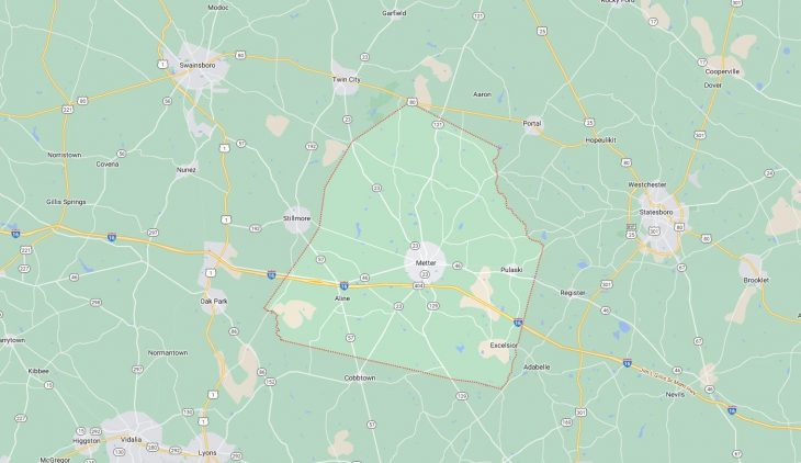
Cities and Towns in Candler County, Georgia
Founded in 1914, Candler County is one of 159 counties in the state of Georgia. Historically, Candler County was formed from Bulloch, Emanuel and Tattnall counties. The city of Metter is the county seat. With FIPS code of 43, Candler County has a population of 11,037 and area of 247 square miles (640 km²).
List of all cities in Candler County, GA alphabetically
City/Town | Postal Code | Area Code |
Excelsior, GA | 30439 | 912 |
Metter, GA | 30439 | 912 |
Pulaski, GA | 30451 | 912 |
Major Cities and Towns in Candler County, Georgia
Metter
Area, Population, Zip Codes, and Coordinates
- Area: 7.7 square miles
- Population: Approximately 4,000
- Zip Codes: 30439
- Latitude: 32.3979° N
- Longitude: 82.0607° W
City Location and History
Metter, the county seat of Candler County, is centrally located in southeastern Georgia. Founded in the late 19th century, Metter has a rich history tied to the expansion of the railroad. The city was officially incorporated in 1903, and its growth was fueled by agriculture, particularly cotton farming, which was a major economic driver. Over time, Metter developed into a community known for its Southern hospitality, a tradition that continues today. The city’s motto, “Everything’s Better in Metter,” reflects its commitment to preserving a high quality of life for its residents.
Major Schools and Landmarks
Metter is home to the Candler County School District, which includes Metter Elementary, Metter Middle, and Metter High School. These institutions serve as the educational backbone of the community. Notable landmarks include the Guido Gardens, a serene garden space that attracts visitors from across the region, and the Candler County Courthouse, a historic building that stands as a testament to the city’s past. The annual Another Bloomin’ Festival is a major event that highlights the city’s cultural vibrancy.
Pulaski
Area, Population, Zip Codes, and Coordinates
- Area: 1.3 square miles
- Population: Approximately 250
- Zip Codes: 30451
- Latitude: 32.3912° N
- Longitude: 82.1698° W
City Location and History
Pulaski is a small town located in the southern part of Candler County, Georgia. Named after Casimir Pulaski, a Polish nobleman who fought for American independence, the town has a long history dating back to the early 1800s. Pulaski played a modest role in the development of the county, primarily as a rural farming community. Despite its small size, Pulaski has maintained a close-knit community atmosphere, where residents take pride in their heritage and local traditions.
Major Schools and Landmarks
Though small, Pulaski is served by nearby schools in the Candler County School District, ensuring that children in the area have access to quality education. The town’s most notable landmark is the Pulaski Monument, a tribute to the town’s namesake, which stands as a symbol of the community’s historical significance. The surrounding countryside offers scenic views and opportunities for outdoor activities, making Pulaski a peaceful retreat from the busier urban centers.
Aline
Area, Population, Zip Codes, and Coordinates
- Area: 0.9 square miles
- Population: Approximately 100
- Zip Codes: 30420
- Latitude: 32.4163° N
- Longitude: 82.0886° W
City Location and History
Aline is a small, unincorporated community located in the northern part of Candler County, Georgia. Like many small towns in the region, Aline’s history is rooted in agriculture, with the community originally established as a farming settlement. Over the years, Aline has retained its rural charm and remains a predominantly agricultural area. The town has seen little development, which has allowed it to maintain its historical character and close connection to the land.
Major Schools and Landmarks
Educational needs for Aline’s residents are met by the Candler County School District, with schools located in nearby Metter. While Aline does not boast major landmarks, its significance lies in its representation of Georgia’s rural past. The area surrounding Aline is known for its natural beauty, with vast fields and forests that are characteristic of the region. The simplicity of life in Aline is a draw for those looking to experience a slower pace and a strong sense of community.
Canoochee
Area, Population, Zip Codes, and Coordinates
- Area: 1.0 square miles
- Population: Approximately 200
- Zip Codes: 30420
- Latitude: 32.3811° N
- Longitude: 82.0625° W
City Location and History
Canoochee is another small, unincorporated community within Candler County, situated in the southeastern part of the county. Named after the Canoochee River, the town’s history is intertwined with the natural environment, where agriculture and forestry have been the mainstays of the local economy. Canoochee has a rich cultural heritage, with roots that go back to the early settlers who relied on the river for transportation and sustenance.
Major Schools and Landmarks
As with other small towns in Candler County, educational facilities for Canoochee’s residents are provided by the schools in Metter. The Canoochee River itself is the most notable landmark, offering opportunities for fishing, kayaking, and other outdoor activities. The town’s rustic charm and natural surroundings make it an ideal spot for those seeking a quiet, rural lifestyle. The community hosts small, local events that reflect its cultural traditions and close-knit nature.