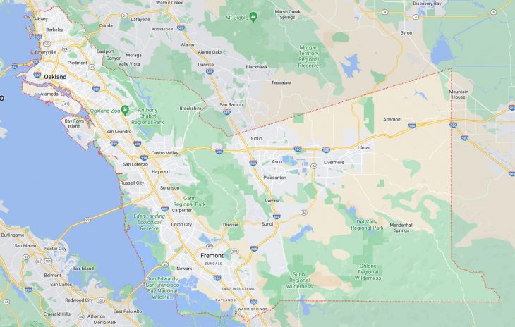
Cities and Towns in Alameda County, California
Founded in 1853, Alameda County is one of 58 counties in the state of California. Historically, Alameda County was formed from Contra Costa and Santa Clara. The city of Oakland is the county seat. With FIPS code of 1, Alameda County has a population of 1,648,556 and area of 738 square miles (1,911 km²).
List of all cities in Alameda County, CA alphabetically
City/Town | Postal Code | Area Code |
Alameda, CA | 94501 | 510 |
94502 | 510 | |
Alameda Point, CA | 94501 | 510 |
Albany, CA | 94706 | 510 |
94707 | 510 | |
94710 | 510 | |
Berkeley, CA | 94701 | 510 |
94702 | 510 | |
94703 | 510 | |
94704 | 510 | |
94705 | 510 | |
94706 | 510 | |
94707 | 510 | |
94708 | 510 | |
94709 | 510 | |
94710 | 510 | |
94712 | 510 | |
94720 | 510 | |
Blue Cross, CA | 94659 | 510 |
Castro Valley, CA | 94546 | 510 |
94552 | 510 | |
Dublin, CA | 94568 | 925 |
Ebmud, CA | 94649 | 510 |
Emeryville, CA | 94608 | 510 |
94662 | 510 | |
Fremont, CA | 94536 | 510 |
94537 | 510 | |
94538 | 510 | |
94539 | 510 | |
94555 | 510 | |
Hayward, CA | 94540 | 510 |
94541 | 510 | |
94542 | 510 | |
94543 | 510 | |
94544 | 510 | |
94545 | 510 | |
94546 | 510 | |
94552 | 510 | |
94557 | 510 | |
Kaiser Services, CA | 94666 | 510 |
Kensington, CA | 94706 | 510 |
94707 | 510 | |
94708 | 510 | |
Livermore, CA | 94550 | 925 |
94551 | 925 | |
Mount Eden, CA | 94557 | 510 |
Newark, CA | 94560 | 510 |
Oakland, CA | 94601 | 510 |
94602 | 510 | |
94603 | 510 | |
94604 | 510 | |
94605 | 510 | |
94606 | 510 | |
94607 | 510 | |
94608 | 510 | |
94609 | 510 | |
94610 | 510 | |
94611 | 510 | |
94612 | 510 | |
94613 | 510 | |
94614 | 510 | |
94615 | 510 | |
94617 | 510 | |
94618 | 510 | |
94619 | 510 | |
94620 | 510 | |
94621 | 510 | |
94622 | 510 | |
94623 | 510 | |
94624 | 510 | |
94649 | 510 | |
94659 | 510 | |
94660 | 510 | |
94661 | 510 | |
94662 | 510 | |
94666 | 510 | |
Oakland International Service Center, CA | 94622 | 510 |
Philatelic Center, CA | 94612 | 510 |
Piedmont, CA | 94602 | 510 |
94610 | 510 | |
94611 | 510 | |
94618 | 510 | |
94620 | 510 | |
Pleasanton, CA | 94566 | 925 |
94568 | 925 | |
94588 | 925 | |
Safeway Stores, CA | 94660 | 510 |
San Leandro, CA | 94577 | 510 |
94578 | 510 | |
94579 | 510 | |
San Lorenzo, CA | 94580 | 510 |
Sunol, CA | 94586 | 925 |
UC Berkeley, CA | 94720 | 510 |
Union City, CA | 94587 | 510 |
Major Cities and Towns in Alameda County, California
Oakland
Area, Population, and Geographic Coordinates
- Area: 78.0 square miles
- Population: Approximately 440,646 (as of 2020)
- Zip Codes: 94601, 94602, 94603, 94605, 94606, 94607, 94608, 94609, 94610, 94611, 94612, 94613, 94618, 94619, 94621
- Latitude: 37.8044° N
- Longitude: 122.2711° W
Location and History
Oakland is the largest city in Alameda County and serves as a major hub in the San Francisco Bay Area. Located directly across the bay from San Francisco, Oakland was founded in 1852 and quickly developed into an industrial powerhouse due to its strategic location along the coast and its proximity to the Transcontinental Railroad. The city became a key port and transportation center, facilitating the growth of shipping, manufacturing, and other industries. Over the years, Oakland has been a site of significant cultural and political movements, particularly in the 1960s and 1970s, with the rise of the Black Panther Party and various labor movements. Today, Oakland is known for its diverse population, vibrant arts scene, and ongoing efforts toward social justice and urban revitalization.
Major Schools and Landmarks
Oakland is served by the Oakland Unified School District, with notable institutions including Oakland Technical High School and Skyline High School. The city is home to numerous landmarks, including Lake Merritt, one of the oldest wildlife refuges in North America, and the historic Fox Theater, a renowned venue for live performances. The Oakland Museum of California offers a deep dive into the state’s history, art, and natural sciences, while Jack London Square, named after the famous author who once lived in the city, serves as a popular waterfront destination with restaurants, shops, and entertainment. Oakland’s rich history, cultural diversity, and significant landmarks make it a key city in Alameda County.
Fremont
Area, Population, and Geographic Coordinates
- Area: 88.4 square miles
- Population: Approximately 230,504 (as of 2020)
- Zip Codes: 94536, 94538, 94539, 94555
- Latitude: 37.5483° N
- Longitude: 121.9886° W
Location and History
Fremont is located in the southern part of Alameda County and is part of the East Bay region of the San Francisco Bay Area. The city was incorporated in 1956, bringing together five smaller communities: Centerville, Niles, Irvington, Mission San Jose, and Warm Springs. This merger created what is now one of the largest cities in the Bay Area. Fremont has a rich history dating back to the Spanish mission era, particularly around the Mission San Jose area, which was established in 1797. The city has evolved from a predominantly agricultural area to a high-tech hub, thanks to its proximity to Silicon Valley. Today, Fremont is known for its diverse population, strong economy, and expansive parks and recreational spaces.
Major Schools and Landmarks
Fremont is served by the Fremont Unified School District, with notable schools including Mission San Jose High School and Irvington High School. The city is home to several significant landmarks, such as the Mission San Jose, a historic Spanish mission that still stands today, and the Niles Canyon Railway, which offers scenic train rides through the beautiful canyon. Fremont is also known for its extensive park system, including Central Park and Lake Elizabeth, a popular spot for outdoor activities. The Ardenwood Historic Farm provides a glimpse into the area’s agricultural past, while the Pacific Commons Shopping Center offers modern retail and dining options. Fremont’s blend of history, cultural diversity, and modern amenities make it an important city in Alameda County.
Berkeley
Area, Population, and Geographic Coordinates
- Area: 17.7 square miles
- Population: Approximately 124,321 (as of 2020)
- Zip Codes: 94702, 94703, 94704, 94705, 94707, 94708, 94709, 94710, 94720
- Latitude: 37.8715° N
- Longitude: 122.2730° W
Location and History
Berkeley is located on the eastern shore of the San Francisco Bay, directly across from San Francisco, and is home to the prestigious University of California, Berkeley. Founded in 1878, the city grew around the university, which has been a major influence on its development. Berkeley became a center for progressive politics, intellectual thought, and social activism, particularly during the 1960s when it was at the forefront of the Free Speech Movement and various civil rights activities. The city is known for its liberal culture, environmental initiatives, and vibrant arts scene. Berkeley’s location along the bay provides stunning views and easy access to both urban amenities and natural beauty.
Major Schools and Landmarks
Berkeley is served by the Berkeley Unified School District, with Berkeley High School being one of the top public schools in the area. The University of California, Berkeley, is the city’s most prominent landmark, renowned for its academic excellence and beautiful campus, which includes the iconic Sather Tower (The Campanile) and Memorial Glade. The Berkeley Art Museum and Pacific Film Archive is a major cultural institution, while the Berkeley Marina and Tilden Regional Park offer outdoor recreational opportunities. The Gourmet Ghetto, a neighborhood known for its pioneering role in the farm-to-table movement, highlights Berkeley’s influence on the culinary world. Berkeley’s combination of academic prestige, cultural vibrancy, and natural beauty make it a standout city in Alameda County.
Hayward
Area, Population, and Geographic Coordinates
- Area: 63.7 square miles
- Population: Approximately 162,954 (as of 2020)
- Zip Codes: 94541, 94542, 94544, 94545
- Latitude: 37.6688° N
- Longitude: 122.0808° W
Location and History
Hayward is located in the East Bay region of Alameda County, positioned between San Leandro and Fremont. The city was founded in 1852 and named after William Hayward, who established a hotel in the area that became a popular stop for travelers. Hayward developed rapidly during the late 19th and early 20th centuries, driven by agriculture, canning, and manufacturing. The city has evolved into a diverse urban center with a strong industrial base, complemented by residential and commercial development. Hayward’s location along major transportation routes, including Interstate 880 and the BART system, has made it an attractive place for businesses and residents alike. The city is known for its cultural diversity, educational institutions, and growing economy.
Major Schools and Landmarks
Hayward is served by the Hayward Unified School District, with notable schools including Hayward High School and Tennyson High School. The city is home to California State University, East Bay, a major educational institution that offers a wide range of undergraduate and graduate programs. Hayward’s landmarks include the Hayward Japanese Gardens, a beautifully landscaped garden that offers a peaceful retreat in the heart of the city, and the Hayward Shoreline Interpretive Center, which provides educational programs and trails along the San Francisco Bay. The historic downtown area features a variety of shops, restaurants, and cultural venues, including the Hayward Area Historical Society. Hayward’s blend of educational opportunities, cultural diversity, and economic growth make it a key city in Alameda County.
Alameda
Area, Population, and Geographic Coordinates
- Area: 23.0 square miles
- Population: Approximately 78,280 (as of 2020)
- Zip Codes: 94501, 94502
- Latitude: 37.7652° N
- Longitude: 122.2416° W
Location and History
Alameda is located on Alameda Island and Bay Farm Island in the San Francisco Bay, directly adjacent to Oakland. The city was incorporated in 1854 and developed as a residential community with a strong maritime tradition. Alameda’s location on the bay made it a key shipping and naval center, particularly during World War II, when the Alameda Naval Air Station played a crucial role in the war effort. After the base’s closure in 1997, Alameda transitioned into a vibrant, waterfront community known for its historic architecture, tree-lined streets, and recreational opportunities. The city’s small-town feel, combined with its proximity to larger urban centers, makes it a popular place to live in the Bay Area.
Major Schools and Landmarks
Alameda is served by the Alameda Unified School District, with schools such as Alameda High School and Encinal High School providing education to the community. The city is home to several notable landmarks, including the USS Hornet Museum, a historic aircraft carrier that is now a museum and event venue, and the Alameda Theatre & Cineplex, a beautifully restored Art Deco movie theater. The city’s parks, such as Crown Memorial State Beach, offer residents and visitors access to the waterfront and stunning views of the San Francisco skyline. The Alameda Point redevelopment project is transforming the former naval base into a mixed-use area with housing, businesses, and open spaces. Alameda’s blend of history, community spirit, and scenic beauty make it a unique and desirable city in Alameda County.
Pleasanton
Area, Population, and Geographic Coordinates
- Area: 24.3 square miles
- Population: Approximately 79,871 (as of 2020)
- Zip Codes: 94566, 94588
- Latitude: 37.6624° N
- Longitude: 121.8747° W
Location and History
Pleasanton is located in the eastern part of Alameda County, in the Tri-Valley area, which also includes Dublin, Livermore, and San Ramon. The city was founded in 1894 and quickly became a key agricultural center, known for its hop fields and dairy farms. Pleasanton’s historic downtown area reflects its early roots, with well-preserved buildings and a strong sense of community. In the latter half of the 20th century, Pleasanton transformed into a suburban community with a thriving economy, driven by its proximity to Silicon Valley and the development of business parks and residential areas. Today, Pleasanton is known for its high quality of life, excellent schools, and vibrant community events.
Major Schools and Landmarks
Pleasanton is served by the Pleasanton Unified School District, with Amador Valley High School and Foothill High School being the city’s top public schools. The city’s major landmarks include the Alameda County Fairgrounds, which hosts the annual Alameda County Fair, one of the largest county fairs in California. The historic downtown area features a variety of shops, restaurants, and cultural venues, including the Firehouse Arts Center. Pleasanton’s parks and open spaces, such as Shadow Cliffs Regional Recreation Area, provide opportunities for outdoor activities. The city’s combination of historical charm, suburban amenities, and economic vitality make it an important part of Alameda County.
Livermore
Area, Population, and Geographic Coordinates
- Area: 25.2 square miles
- Population: Approximately 91,617 (as of 2020)
- Zip Codes: 94550, 94551
- Latitude: 37.6819° N
- Longitude: 121.7680° W
Location and History
Livermore is located in the easternmost part of Alameda County and is part of the Tri-Valley area. The city was founded in 1869 by William Mendenhall, who named it after his friend, Robert Livermore, a prominent local rancher. Livermore is one of the oldest wine regions in California, with the first commercial vineyards planted in the 1840s. The city’s wine industry remains a significant part of its economy and cultural identity, with many wineries and vineyards still in operation today. Livermore is also known for its scientific research institutions, including the Lawrence Livermore National Laboratory and the Sandia National Laboratories, which have contributed to its reputation as a center for innovation and technology.
Major Schools and Landmarks
Livermore is served by the Livermore Valley Joint Unified School District, with Livermore High School and Granada High School being the main public high schools. The city’s major landmarks include the Livermore Valley Wine Country, which features over 50 wineries and is a popular destination for wine enthusiasts. The historic downtown area, with its preserved buildings and vibrant arts scene, is another key attraction, offering shops, restaurants, and cultural events. The Bankhead Theater, located downtown, hosts performances ranging from theater to music and dance. Livermore’s combination of historical significance, scientific research, and cultural attractions make it a vital city in Alameda County.