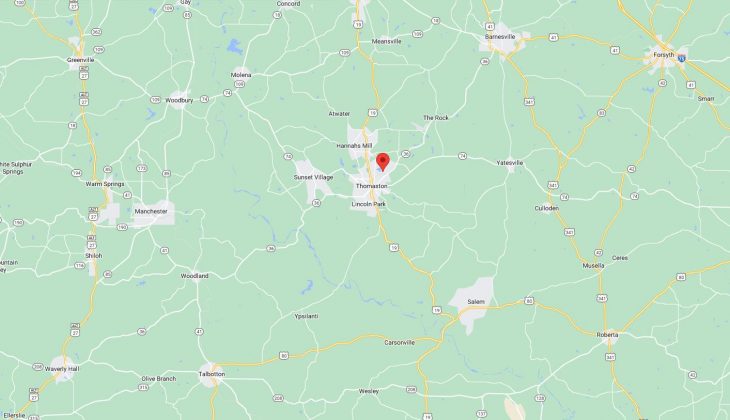
Cities and Towns in Upson County, Georgia

Founded in 1824, Upson County is one of 159 counties in the state of Georgia. Historically, Upson County was formed from Crawford and Pike Counties. The city of Thomaston is the county seat. With FIPS code of 293, Upson County has a population of 27,720 and area of 326 square miles (844 km²).

List of all cities in Upson County, GA alphabetically

City/Town Postal Code Area Code
The Rock, GA 30285 706/762
Thomaston, GA 30286 706/762
Yatesville, GA 31097 706/762

Major Cities and Towns in Upson County, Georgia

Thomaston

Area, Population, Zip Codes, Latitude and Longitude

  • Area: 9.7 square miles
  • Population: Approximately 9,000 (as of the 2020 census)
  • Zip Codes: 30286
  • Latitude and Longitude: 32.8885° N, 84.3263° W

Location and History

Thomaston is the county seat and largest city in Upson County, Georgia, located in the west-central part of the state. Founded in 1825, the city was named after General Jett Thomas, a hero of the War of 1812 who also played a role in the construction of the University of Georgia. Thomaston quickly developed as a hub for the cotton industry, with its economy historically centered around textile manufacturing. The B.F. Goodrich tire company once operated one of the largest textile mills in the South here, which was a major employer for the region. Although the textile industry has since declined, Thomaston remains an important regional center for commerce and culture.

Major Schools and Landmarks

Thomaston is served by the Thomaston-Upson School System, which includes Upson-Lee High School, Upson-Lee Middle School, and Upson-Lee Primary School. The city is home to several notable landmarks, including the Upson County Courthouse, built in 1908, which is listed on the National Register of Historic Places. The Ritz Theatre, a historic theater built in the 1920s, has been restored and now serves as a venue for movies and live performances. Sprewell Bluff Park, located along the Flint River just outside the city, offers opportunities for hiking, fishing, and picnicking in a scenic natural setting. Thomaston’s rich history, educational resources, and cultural landmarks make it the heart of Upson County.

Yatesville

Area, Population, Zip Codes, Latitude and Longitude

  • Area: 1.2 square miles
  • Population: Approximately 350 (as of the 2020 census)
  • Zip Codes: 31097
  • Latitude and Longitude: 32.9004° N, 84.1427° W

Location and History

Yatesville is a small town located in Upson County, Georgia, about 10 miles east of Thomaston. The town was incorporated in 1896 and named after Matthew Yates, an early settler who was influential in the development of the area. Yatesville developed as a rural farming community, with its economy traditionally based on agriculture, particularly cotton farming. The arrival of the railroad in the late 19th century helped spur growth, making Yatesville a local center for commerce and transportation. Despite its small size, Yatesville has retained much of its historical charm, with many buildings reflecting its late 19th and early 20th-century origins.

Major Schools and Landmarks

Yatesville is served by the Thomaston-Upson School System, with students typically attending schools in nearby Thomaston, such as Upson-Lee High School. The town’s landmarks include several historic homes and churches that reflect its long-standing community and rural heritage. The nearby Flint River provides opportunities for outdoor activities such as fishing, boating, and hiking, making it a popular destination for residents and visitors alike. Yatesville’s annual events, including local church gatherings and community fairs, reflect the town’s strong sense of tradition and close-knit community spirit. Yatesville’s rural charm, historical roots, and community values make it an important part of Upson County.

The Rock

Area, Population, Zip Codes, Latitude and Longitude

  • Area: N/A (Unincorporated community)
  • Population: Approximately 200 (as of the 2020 census)
  • Zip Codes: 30285
  • Latitude and Longitude: 32.9687° N, 84.2905° W

Location and History

The Rock is an unincorporated community located in Upson County, Georgia, about 7 miles north of Thomaston. The community was established in the early 19th century and named after a large rock formation that served as a landmark for travelers and settlers in the area. The Rock developed as a small agricultural community, with its economy centered around farming and the timber industry. The area is known for its picturesque landscapes, with rolling hills and farmland providing a scenic backdrop for the community. The Rock has maintained its rural character and remains a close-knit community with a strong connection to the land.

Major Schools and Landmarks

The Rock is served by the Thomaston-Upson School System, with students attending schools in Thomaston, including Upson-Lee High School. The community is home to several historic sites, including the old The Rock School, which served the community in the early 20th century and is now a local landmark. The nearby Sprewell Bluff Park offers opportunities for outdoor recreation, including hiking, fishing, and picnicking along the Flint River. The Rock’s rural charm, historical significance, and natural beauty make it a unique and cherished part of Upson County.

Sunset Village

Area, Population, Zip Codes, Latitude and Longitude

  • Area: N/A (Unincorporated community)
  • Population: Approximately 300 (as of the 2020 census)
  • Zip Codes: 30286 (Thomaston)
  • Latitude and Longitude: 32.8643° N, 84.3019° W

Location and History

Sunset Village is an unincorporated community located in Upson County, Georgia, on the outskirts of Thomaston. The community developed in the mid-20th century as a residential area for workers employed in the local textile mills and other industries in Thomaston. Sunset Village is characterized by its suburban layout, with modest homes and quiet streets offering a peaceful environment for families. The community has grown slowly over the years, maintaining its close-knit atmosphere while benefiting from its proximity to the amenities and services available in Thomaston.

Major Schools and Landmarks

Sunset Village is served by the Thomaston-Upson School System, with students attending nearby schools in Thomaston, including Upson-Lee High School. The community is primarily residential, with few commercial or public landmarks, but it benefits from its proximity to Thomaston’s cultural and recreational facilities. Residents of Sunset Village enjoy easy access to local parks, shopping centers, and schools, making it a convenient and attractive place to live. The community’s annual events, including neighborhood gatherings and holiday celebrations, reflect the strong sense of community and pride among its residents. Sunset Village’s suburban charm, close-knit community, and convenient location make it a valued part of Upson County.

Map of Cities in Upson County, GA

Map of Cities in Upson County, GA