Cities and Towns in Twiggs County, Georgia
Founded in 1809, Twiggs County is one of 159 counties in the state of Georgia. Historically, Twiggs County was formed from Wilkinson County. The city of Jeffersonville is the county seat. With FIPS code of 289, Twiggs County has a population of 7,856 and area of 360 square miles (932 km²).
List of all cities in Twiggs County, GA alphabetically
| City/Town | Postal Code | Area Code |
| Danville, GA | 31017 | 478 |
| Dry Branch, GA | 31020 | 478 |
| Jeffersonville, GA | 31044 | 478 |
Major Cities and Towns in Twiggs County, Georgia
Jeffersonville
Area, Population, Zip Codes, Latitude and Longitude
- Area: 3.9 square miles
- Population: Approximately 1,000 (as of the 2020 census)
- Zip Codes: 31044
- Latitude and Longitude: 32.6837° N, 83.3502° W
Location and History
Jeffersonville is the county seat and largest city in Twiggs County, Georgia. Established in 1809 and named after Thomas Jefferson, the third President of the United States, Jeffersonville has been the administrative and economic center of the county for over two centuries. The city developed as a hub for agriculture, particularly cotton farming, which was a major industry in the region during the 19th and early 20th centuries. Jeffersonville’s location along key transportation routes, including highways and railroads, helped to facilitate its growth and sustain its economy. Over the years, the city has retained its small-town charm, with many historic buildings still standing, reflecting its rich heritage.
Major Schools and Landmarks
Jeffersonville is served by the Twiggs County School District, which includes Twiggs County High School, Twiggs County Middle School, and Jeffersonville Elementary School. The city is home to several significant landmarks, including the Twiggs County Courthouse, built in 1903, which is listed on the National Register of Historic Places. The courthouse is an excellent example of neoclassical architecture and serves as a symbol of the county’s legal and civic history. The nearby Ocmulgee River offers opportunities for fishing, boating, and other outdoor activities. Jeffersonville’s combination of historical significance, educational resources, and community events, such as the annual Jeffersonville Fall Festival, make it the heart of Twiggs County.
Danville
Area, Population, Zip Codes, Latitude and Longitude
- Area: 1.5 square miles
- Population: Approximately 200 (as of the 2020 census)
- Zip Codes: 31017
- Latitude and Longitude: 32.6004° N, 83.2521° W
Location and History
Danville is a small town located in Twiggs County, Georgia, near the border with Wilkinson and Laurens counties. The town was incorporated in 1891 and was named after Daniel Gugel, an early settler and businessman who played a key role in the town’s development. Danville developed as a rural agricultural community, with its economy traditionally based on farming, particularly cotton, and later tobacco. The arrival of the railroad in the late 19th century provided a boost to the local economy, allowing farmers to transport their goods to larger markets more efficiently. Today, Danville remains a small, close-knit community with a strong connection to its agricultural roots.
Major Schools and Landmarks
Danville is served by the Twiggs County School District, with students typically attending schools in nearby Jeffersonville, such as Twiggs County High School. The town’s landmarks include several historic homes and churches that reflect its long-standing community and rural heritage. The surrounding countryside offers opportunities for outdoor activities such as hunting, fishing, and farming, which remain popular pastimes for residents. Danville’s annual events, including local church gatherings and community fairs, highlight the town’s strong sense of tradition and close-knit community spirit. Despite its small size, Danville’s historical significance, rural charm, and community values make it an important part of Twiggs County.
Allentown
Area, Population, Zip Codes, Latitude and Longitude
- Area: 0.8 square miles
- Population: Approximately 150 (as of the 2020 census)
- Zip Codes: 31003
- Latitude and Longitude: 32.5849° N, 83.2196° W
Location and History
Allentown is a small town located in Twiggs County, Georgia, with parts of the town extending into neighboring Wilkinson and Laurens counties. The town was incorporated in 1901 and was named after John Allen, a prominent local figure who was instrumental in its founding. Allentown developed as a rural community, with its economy historically based on agriculture and small-scale trade. The town’s growth was modest, and it has remained a small, quiet community throughout its history. Despite its size, Allentown has a rich history and a strong sense of community, with residents taking pride in their town’s heritage and rural lifestyle.
Major Schools and Landmarks
Allentown is served by the Twiggs County School District, with students attending schools in nearby Jeffersonville. The town’s landmarks include the historic Allentown Methodist Church, which has been a central gathering place for the community since its founding. The surrounding rural landscape offers opportunities for outdoor activities such as farming, hunting, and fishing. Allentown’s annual events, including church functions and local fairs, reflect the town’s strong sense of tradition and community spirit. Allentown’s rural charm, historical significance, and close-knit community make it a valued part of Twiggs County.
Dry Branch
Area, Population, Zip Codes, Latitude and Longitude
- Area: N/A (Unincorporated community)
- Population: Approximately 500 (as of the 2020 census)
- Zip Codes: 31020
- Latitude and Longitude: 32.7715° N, 83.4778° W
Location and History
Dry Branch is an unincorporated community located in Twiggs County, Georgia, near the border with Bibb County. The community was established in the 19th century and developed as a small rural settlement, with its name likely derived from a nearby creek that frequently ran dry. Dry Branch has historically been an agricultural community, with its economy centered around farming, particularly cotton, and later kaolin mining, which became an important industry in the region. The community has maintained its rural character and close-knit atmosphere over the years, with many residents continuing to work in agriculture and related industries.
Major Schools and Landmarks
Dry Branch is served by the Twiggs County School District, with students attending schools in nearby Jeffersonville, such as Twiggs County High School. The community is known for its proximity to kaolin mining operations, which have played a significant role in the local economy. The nearby Ocmulgee River provides opportunities for outdoor recreation, including fishing, boating, and hiking. Dry Branch’s annual events, such as local church gatherings and community picnics, highlight the strong sense of tradition and community spirit that characterizes the area. Despite its small size, Dry Branch’s historical significance, rural charm, and community values make it a unique and valued part of Twiggs County.
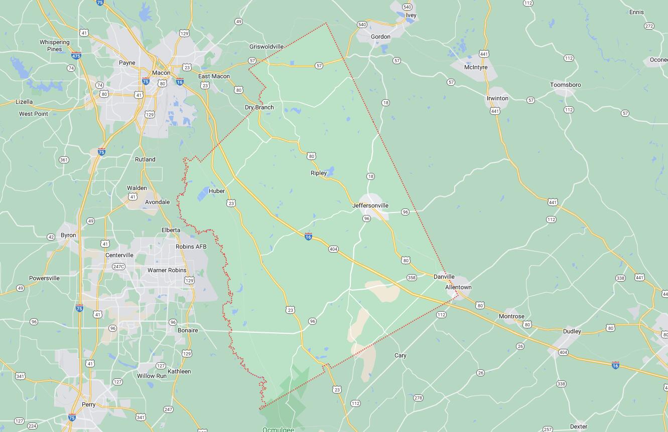
Map of Cities in Twiggs County, GA