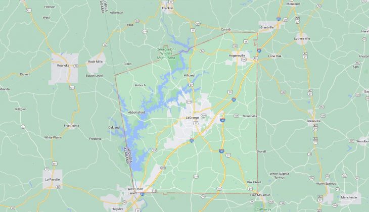
Cities and Towns in Troup County, Georgia
Founded in 1826, Troup County is one of 159 counties in the state of Georgia. Historically, Troup County was formed from Creek Cession of 1826. The city of LaGrange is the county seat. With FIPS code of 285, Troup County has a population of 69,720 and area of 414 square miles (1,072 km²).
List of all cities in Troup County, GA alphabetically
City/Town | Postal Code | Area Code |
Hogansville, GA | 30230 | 706/762 |
Lagrange, GA | 30240 | 706/762 |
30241 | 706/762 | |
30261 | 706/762 | |
Mountville, GA | 30261 | 706/762 |
West Point, GA | 31833 | 706/762 |
Major Cities and Towns in Troup County, Georgia
LaGrange
Area, Population, Zip Codes, Latitude and Longitude
- Area: 43.6 square miles
- Population: Approximately 30,000 (as of the 2020 census)
- Zip Codes: 30240, 30241
- Latitude and Longitude: 33.0393° N, 85.0310° W
Location and History
LaGrange is the county seat and largest city in Troup County, Georgia, located in the west-central part of the state. The city was established in 1828 and named after the Marquis de Lafayette’s estate in France, reflecting the town’s connection to the American Revolutionary War hero. LaGrange quickly grew as a center for agriculture and trade, with cotton being the dominant crop. The arrival of the railroad in the mid-19th century further spurred growth, turning LaGrange into a key commercial hub in the region. During the Civil War, the city was spared destruction by Union forces due to the intervention of local women who negotiated with the approaching troops. Today, LaGrange is known for its rich history, educational institutions, and vibrant cultural scene.
Major Schools and Landmarks
LaGrange is served by the Troup County School System, which includes LaGrange High School, Gardner Newman Middle School, and Hollis Hand Elementary School. The city is also home to LaGrange College, the oldest private college in Georgia, founded in 1831. Notable landmarks in LaGrange include the Bellevue Mansion, a beautiful example of Greek Revival architecture built in the 1850s, and Hills & Dales Estate, the historic home of textile magnate Fuller E. Callaway. The LaGrange Art Museum, housed in a former jail, and the Sweetland Amphitheatre, which hosts concerts and events, are key cultural attractions. LaGrange’s blend of historical significance, educational resources, and cultural amenities makes it the heart of Troup County.
West Point
Area, Population, Zip Codes, Latitude and Longitude
- Area: 4.7 square miles
- Population: Approximately 3,700 (as of the 2020 census)
- Zip Codes: 31833
- Latitude and Longitude: 32.8771° N, 85.1847° W
Location and History
West Point is a city located on the western border of Troup County, Georgia, straddling the Chattahoochee River, which serves as the state line with Alabama. The city was incorporated in 1835 and named for its location at the westernmost point of the Chattahoochee River’s navigable route. West Point developed as a key trading center, with its economy historically based on river transportation, railroads, and textile manufacturing. The city played a significant role in the industrialization of the region, with the West Point Manufacturing Company being one of the largest employers in the area. Today, West Point is known for its historic downtown, the nearby Kia Motors Manufacturing Georgia plant, and its scenic location along the river.
Major Schools and Landmarks
West Point is served by the Troup County School System, with students attending Long Cane Middle School and Troup County High School in nearby LaGrange. Notable landmarks in West Point include the historic New Horizon Community Theatre, which offers a variety of performances and events throughout the year, and the West Point Lake, a 25,900-acre reservoir that provides recreational opportunities such as boating, fishing, and camping. The city’s downtown area features well-preserved historic buildings, reflecting its 19th-century roots. The annual Chattahoochee Valley Daylily Festival is a popular event that celebrates the city’s horticultural heritage. West Point’s rich history, educational resources, and natural beauty make it an important part of Troup County.
Hogansville
Area, Population, Zip Codes, Latitude and Longitude
- Area: 6.7 square miles
- Population: Approximately 3,000 (as of the 2020 census)
- Zip Codes: 30230
- Latitude and Longitude: 33.1726° N, 84.9141° W
Location and History
Hogansville is a city located in the northern part of Troup County, Georgia. The city was incorporated in 1870 and named after William Hogan, an early settler who was instrumental in bringing the railroad to the area. Hogansville developed as a railroad town, with its economy centered around transportation, textiles, and agriculture. The city’s historic downtown area, with its Victorian-era architecture, reflects the prosperity of its early years. Hogansville has maintained much of its small-town charm, with a focus on preserving its historical heritage while fostering a strong sense of community.
Major Schools and Landmarks
Hogansville is served by the Troup County School System, with students attending Hogansville Elementary School, Callaway Middle School, and Callaway High School. The city is home to several significant landmarks, including the historic Grand Hotel, built in the 1890s, which now serves as a community center. The Hogansville Tower Trail is a popular walking path that offers scenic views of the city and its surrounding landscapes. The annual Hummingbird Festival, held each October, celebrates the town’s heritage with arts, crafts, food, and music, attracting visitors from across the region. Hogansville’s blend of historical significance, educational resources, and community spirit makes it a cherished part of Troup County.
Luthersville
Area, Population, Zip Codes, Latitude and Longitude
- Area: 3.1 square miles
- Population: Approximately 900 (as of the 2020 census)
- Zip Codes: 30251
- Latitude and Longitude: 33.2096° N, 84.7474° W
Location and History
Luthersville is a small town located in the northeastern part of Troup County, Georgia. The town was incorporated in 1872 and named after Martin Luther, the founder of the Protestant Reformation, reflecting the religious heritage of its early settlers. Luthersville developed as an agricultural community, with its economy historically based on farming, particularly cotton and other cash crops. The town has remained small and rural throughout its history, with a close-knit community that values its heritage and traditions. Despite its modest size, Luthersville is known for its peaceful atmosphere and strong sense of community.
Major Schools and Landmarks
Luthersville is served by the Troup County School System, with students typically attending schools in nearby Hogansville or LaGrange. The town is home to several historic churches and homes that reflect its long-standing agricultural heritage. The surrounding countryside offers opportunities for outdoor activities such as farming, hunting, and exploring the natural beauty of the area. Luthersville’s annual events, including local church gatherings and community fairs, highlight the town’s strong sense of tradition and community spirit. Luthersville’s rural charm, historical roots, and community values make it an important part of Troup County.