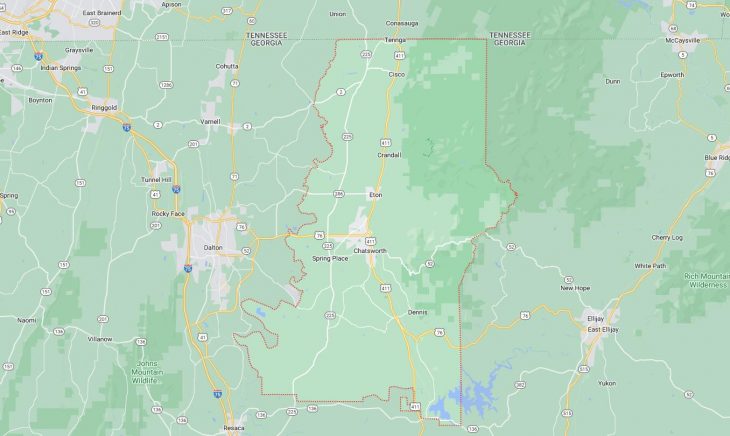
Cities and Towns in Murray County, Georgia
Founded in 1832, Murray County is one of 159 counties in the state of Georgia. Historically, Murray County was formed from Cherokee County. The city of Chatsworth is the county seat. With FIPS code of 213, Murray County has a population of 39,951 and area of 344 square miles (891 km²).
List of all cities in Murray County, GA alphabetically
City/Town | Postal Code | Area Code |
Chatsworth, GA | 30705 | 706/762 |
Cisco, GA | 30708 | 706/762 |
Crandall, GA | 30711 | 706/762 |
Eton, GA | 30724 | 706/762 |
Tennga, GA | 30751 | 706/762 |
Major Cities and Towns in Murray County, Georgia
Chatsworth
Area, Population, Zip Codes, and Coordinates
- Area: 4.9 square miles
- Population: Approximately 4,299 (2020 Census)
- Zip Codes: 30705
- Latitude and Longitude: 34.7657° N, 84.7694° W
Location and History
Chatsworth is the county seat of Murray County, located in the northwestern part of Georgia. The city was incorporated in 1906, and its name is believed to have been inspired by Chatsworth House in England, although some local legends suggest the name came from a sign that fell off a railroad car. Chatsworth developed as a key agricultural and transportation hub in the early 20th century, largely due to its location along the Louisville and Nashville Railroad. The city is situated near the Cohutta Mountains, offering picturesque views and easy access to natural beauty. Chatsworth has grown steadily over the years, maintaining its small-town charm while also serving as a gateway to the natural attractions in the region, including the nearby Fort Mountain State Park.
Major Schools and Landmarks
Chatsworth is served by the Murray County School District, with Murray County High School being the primary educational institution. The school offers a variety of academic and extracurricular programs, including sports and arts. Major landmarks in Chatsworth include the Chief Vann House Historic Site, the former home of Cherokee leader James Vann, which provides a glimpse into the life and culture of the Cherokee people before the Trail of Tears. Fort Mountain State Park is another key attraction, offering hiking trails, scenic overlooks, and the mysterious ancient stone wall at the summit of Fort Mountain. The downtown area of Chatsworth features historic buildings, shops, and restaurants, contributing to the city’s vibrant community life. The annual Prater’s Mill Country Fair is a popular event that celebrates the region’s history and culture with arts and crafts, music, and food.
Eton
Area, Population, Zip Codes, and Coordinates
- Area: 0.8 square miles
- Population: Approximately 900 (2020 Census)
- Zip Codes: 30724
- Latitude and Longitude: 34.8244° N, 84.7666° W
Location and History
Eton is a small town located just north of Chatsworth in Murray County. The town was incorporated in 1906 and named after the English town of Eton, although it was originally called “Houston” before the name was changed. Eton developed as a rural community with strong ties to agriculture, particularly in the production of cotton and later other crops. The town’s growth was modest, with its economy centered around farming and small-scale trade. Over the years, Eton has maintained its small-town atmosphere and rural character, with a close-knit community that values its traditions and history. The town’s location near the Cohutta Wilderness and Fort Mountain makes it an attractive place for those who appreciate outdoor activities and natural beauty.
Major Schools and Landmarks
Eton is part of the Murray County School District, with students attending schools in nearby Chatsworth, including Murray County High School. The town itself does not have a high school but benefits from the educational resources available in the county. Major landmarks in Eton include the historic Eton Elementary School, which has been a central part of the community since the early 20th century. The town is also close to several natural attractions, including the Cohutta Wilderness, which offers opportunities for hiking, camping, and exploring the rugged terrain of the Appalachian Mountains. Eton’s annual community events, such as the Eton Christmas Parade, bring residents together to celebrate their shared heritage and enjoy the close-knit atmosphere of the town. The town’s rural charm and proximity to natural areas make it a peaceful and scenic place to live.
Crandall
Area, Population, Zip Codes, and Coordinates
- Area: Not officially defined as a separate area
- Population: Part of the unincorporated population of Murray County
- Zip Codes: 30711
- Latitude and Longitude: 34.8898° N, 84.7372° W
Location and History
Crandall is an unincorporated community in northern Murray County, known for its rural setting and proximity to the Cohutta Mountains. The community was established in the late 19th century and was named after a local landowner or possibly a railroad official, though the exact origin of the name is uncertain. Crandall developed as a small farming community, with agriculture remaining the primary industry throughout its history. The area is characterized by its scenic landscapes, including rolling hills, forests, and farmland. Crandall has retained its quiet, rural atmosphere, with a strong sense of community and a commitment to preserving its natural surroundings. The community’s location near the Cohutta Wilderness makes it a popular destination for outdoor enthusiasts.
Major Schools and Landmarks
Crandall is part of the Murray County School District, with students attending schools in nearby Chatsworth and Eton, including Murray County High School. The community itself does not have major educational institutions but benefits from the schools available in the surrounding areas. Major landmarks in Crandall include the Cohutta Wilderness, a vast protected area that offers hiking, camping, and wildlife viewing opportunities. The wilderness area is home to diverse flora and fauna, as well as numerous trails that provide access to some of the most rugged and beautiful terrain in Georgia. Crandall’s rural setting and proximity to natural attractions make it a peaceful and scenic place for those who enjoy outdoor activities and a slower pace of life.
Cisco
Area, Population, Zip Codes, and Coordinates
- Area: Not officially defined as a separate area
- Population: Part of the unincorporated population of Murray County
- Zip Codes: 30708
- Latitude and Longitude: 34.9756° N, 84.7344° W
Location and History
Cisco is a small, unincorporated community located in the northern part of Murray County, near the Tennessee state line. The community was established in the late 19th century and developed as a rural farming area. Cisco’s history is closely tied to agriculture, with its residents primarily engaged in farming and timber production. The community’s location in the Appalachian foothills provides it with a scenic backdrop of rolling hills and forests. Over the years, Cisco has remained a small, close-knit community, characterized by its rural charm and strong ties to the land. The community’s proximity to both the Cohutta Wilderness and the Cherokee National Forest in Tennessee makes it an ideal location for those who appreciate outdoor activities.
Major Schools and Landmarks
Cisco is part of the Murray County School District, with students attending schools in nearby towns such as Chatsworth and Eton, including Murray County High School. The community does not have its own schools but is well-served by the educational resources in the county. Major landmarks in Cisco include the surrounding natural areas, particularly the Cherokee National Forest and the Cohutta Wilderness, which offer numerous opportunities for hiking, fishing, camping, and exploring the natural beauty of the region. The community is also known for its rural landscapes, including farms, forests, and small streams that contribute to its scenic beauty. Cisco’s quiet, rural atmosphere and proximity to natural attractions make it a peaceful and attractive place for those seeking a connection to nature and a slower pace of life.