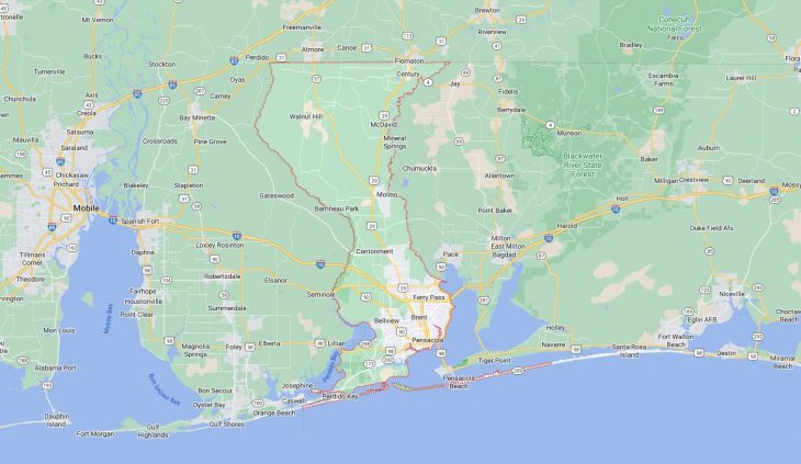
Cities and Towns in Escambia County, Florida

Founded in 1821, Escambia County is one of 67 counties in the state of Florida.  The city of Pensacola is the county seat. With FIPS code of 33, Escambia County has a population of 322,390 and area of 664 square miles (1,720 km²).

List of all cities in Escambia County, FL alphabetically

City/Town Postal Code Area Code
Bellview, FL 32526 850
Cantonment, FL 32533 850
Century, FL 32535 850
City of Pensacola, FL 32521 850
Educ Dev Ctr Corresp, FL 32559 850
Gonzalez, FL 32560 850
Gulf Power, FL 32520 850
Mc David, FL 32568 850
Molino, FL 32577 850
Netpmdsa Saufley Field, FL 32509 850
NTT Corry Field, FL 32511 850
Pcola, FL 32590 850
Pensacola, FL 32501 850
32502 850
32503 850
32504 850
32505 850
32506 850
32507 850
32508 850
32509 850
32511 850
32512 850
32513 850
32514 850
32516 850
32520 850
32521 850
32522 850
32523 850
32524 850
32526 850
32534 850
32559 850
32590 850
32591 850
32592 850
Pensacola Naval Hospital, FL 32512 850
Perdido Key, FL 32507 850
PNS, FL 32590 850
Walnut Hill, FL 32568 850

Major Cities and Towns in Escambia County, Florida

Pensacola

Area, Population, Zip Codes, and Coordinates

  • Area: 40.7 square miles
  • Population: Approximately 54,000 (2023 estimate)
  • Zip Codes: 32501, 32502, 32503, 32504, 32505, 32506, 32507, 32508, 32511, 32512, 32513, 32514, 32516, 32520, 32521, 32522, 32523, 32524, 32526, 32534, 32559, 32591, 32592
  • Latitude and Longitude: 30.4213° N, 87.2169° W

Location and History

Pensacola is the largest city and the county seat of Escambia County, located on the western edge of the Florida Panhandle, bordering the Gulf of Mexico. Known as “The City of Five Flags” due to its diverse history under Spanish, French, British, Confederate, and American rule, Pensacola is one of the oldest European settlements in the United States, established in 1559 by Spanish explorer Tristán de Luna. The city has a rich maritime history, serving as a key naval base and port throughout its history. Pensacola’s deepwater port and its strategic location near the Gulf of Mexico have made it an important military and commercial hub. Today, Pensacola is known for its historic downtown, beautiful beaches, and vibrant cultural scene.

Major Schools and Landmarks

Pensacola is served by the Escambia County School District, with notable schools such as Pensacola High School and Washington High School. The city is also home to the University of West Florida and Pensacola State College. Major landmarks in Pensacola include the Historic Pensacola Village, which preserves several historic buildings and offers insights into the city’s past, and the Pensacola Naval Air Station, home to the National Naval Aviation Museum and the Blue Angels flight demonstration team. The Pensacola Beach, located on Santa Rosa Island, is a major attraction, offering white sandy beaches and clear Gulf waters. Pensacola’s blend of history, education, and natural beauty make it the cultural and economic heart of Escambia County.

Century

Area, Population, Zip Codes, and Coordinates

  • Area: 3.5 square miles
  • Population: Approximately 1,700 (2023 estimate)
  • Zip Codes: 32535
  • Latitude and Longitude: 30.9730° N, 87.2589° W

Location and History

Century is a small town located in the northern part of Escambia County, near the Alabama state line. The town was founded in 1901 as a company town by the Alger-Sullivan Lumber Company, which established a sawmill and named the town in honor of the 20th century. Century grew rapidly during the early 20th century as a center for timber and railroads, serving as a major supplier of lumber to the southeastern United States. The town’s economy was historically tied to the timber industry, and it was known for its strong community spirit and worker-owned businesses. Although the timber industry has declined, Century has retained its small-town character and continues to serve as a residential and agricultural community.

Major Schools and Landmarks

Century is served by the Escambia County School District, with Northview High School and Bratt Elementary School being the primary educational institutions in the area. Major landmarks in Century include the Alger-Sullivan Lumber Company Historic District, which preserves buildings and sites related to the town’s industrial past. The town’s proximity to the Escambia River offers opportunities for fishing, boating, and exploring the natural beauty of North Florida. Century’s rich history, agricultural roots, and close-knit community make it a unique and enduring part of Escambia County.

Gonzalez

Area, Population, Zip Codes, and Coordinates

  • Area: 7.0 square miles
  • Population: Approximately 13,000 (2023 estimate)
  • Zip Codes: 32533, 32560
  • Latitude and Longitude: 30.5891° N, 87.2913° W

Location and History

Gonzalez is an unincorporated community located just north of Pensacola in Escambia County. The area has a long history of agricultural activity, with the community originally centered around farming and timber. In the 20th century, Gonzalez grew as a residential area, benefiting from its proximity to Pensacola and the expansion of suburban developments. The community has retained much of its rural character, with large residential lots and an emphasis on preserving green spaces. Over the years, Gonzalez has become a popular location for families and retirees, offering a quieter alternative to the more urbanized areas of Escambia County.

Major Schools and Landmarks

Gonzalez is served by the Escambia County School District, with Ransom Middle School and Tate High School being the major educational institutions in the area. Major landmarks in Gonzalez include the Escambia River Wildlife Management Area, which provides opportunities for hunting, fishing, and wildlife observation. The community is also home to several parks and recreational facilities, including the Ashton Brosnaham Park, known for its sports fields and family-friendly amenities. Gonzalez’s combination of rural charm, suburban convenience, and access to outdoor activities make it a desirable place to live in Escambia County.

Molino

Area, Population, Zip Codes, and Coordinates

  • Area: 5.9 square miles
  • Population: Approximately 1,300 (2023 estimate)
  • Zip Codes: 32577
  • Latitude and Longitude: 30.7199° N, 87.3344° W

Location and History

Molino is a small, unincorporated community located in the northern part of Escambia County, along U.S. Highway 29. The town was established in the mid-19th century and named “Molino,” the Spanish word for “mill,” due to the presence of grist mills that processed local agricultural products. Molino developed as a rural farming community, with its economy centered around agriculture, particularly cotton, corn, and timber. The town has maintained its rural character over the years, with large tracts of farmland and forested areas defining its landscape. Molino is known for its tight-knit community and its role as a gateway to the more rural parts of Escambia County.

Major Schools and Landmarks

Molino is served by the Escambia County School District, with Molino Park Elementary School and Ernest Ward Middle School being the primary educational institutions. Major landmarks in Molino include the Molino Museum, which preserves the history and heritage of the community, and the Barrineau Park, offering recreational facilities such as hiking trails, picnic areas, and a community center. The nearby Perdido River offers opportunities for kayaking, fishing, and enjoying the natural beauty of the region. Molino’s rural lifestyle, historic roots, and community-oriented environment make it a peaceful and appealing place to live in Escambia County.

Ferry Pass

Area, Population, Zip Codes, and Coordinates

  • Area: 16.3 square miles
  • Population: Approximately 34,000 (2023 estimate)
  • Zip Codes: 32514
  • Latitude and Longitude: 30.5285° N, 87.2119° W

Location and History

Ferry Pass is a large, unincorporated suburban community located just northeast of Pensacola in Escambia County. The area developed as a residential suburb in the mid-20th century, benefiting from its proximity to the University of West Florida and the expanding metropolitan area of Pensacola. Ferry Pass offers a mix of suburban neighborhoods, commercial areas, and natural spaces, making it one of the more populated and diverse communities in the county. The community’s name likely originates from a ferry service that once operated in the area, crossing the nearby Escambia River.

Major Schools and Landmarks

Ferry Pass is served by the Escambia County School District, with Ferry Pass Middle School and Pine Forest High School being key educational institutions. The community is also home to the University of West Florida, a major regional university that offers a wide range of academic programs and cultural events. Major landmarks in Ferry Pass include the Pensacola Bay, which provides opportunities for boating, fishing, and enjoying the scenic waterfront, and the Bay Bluffs Park, known for its hiking trails and panoramic views of the bay. Ferry Pass’s suburban amenities, educational institutions, and access to natural attractions make it a vibrant and attractive community within Escambia County.

Warrington

Area, Population, Zip Codes, and Coordinates

  • Area: 8.0 square miles
  • Population: Approximately 15,000 (2023 estimate)
  • Zip Codes: 32506, 32507
  • Latitude and Longitude: 30.3847° N, 87.3035° W

Location and History

Warrington is a suburban community located just southwest of Pensacola, adjacent to the Pensacola Naval Air Station in Escambia County. The area has a long military history, with its development closely tied to the establishment of the naval base in the early 20th century. Warrington grew as a residential area for military personnel and their families, offering convenient access to the base and the amenities of nearby Pensacola. Over time, Warrington has expanded to include a mix of residential neighborhoods, commercial areas, and parks, serving both the military community and the broader population.

Major Schools and Landmarks

Warrington is served by the Escambia County School District, with Warrington Middle School and Escambia High School being the primary educational institutions. Major landmarks in Warrington include the Pensacola Naval Air Station, which is home to the National Naval Aviation Museum, one of the largest aviation museums in the world, and the historic Fort Barrancas, a 19th-century military fortification that is now part of the Gulf Islands National Seashore. The community’s proximity to the bay and the Gulf of Mexico provides ample opportunities for water-based activities such as boating, fishing, and swimming. Warrington’s military heritage, residential appeal, and access to cultural and recreational resources make it an integral part of Escambia County.

Map of Cities in Escambia County, FL

Map of Cities in Escambia County, FL