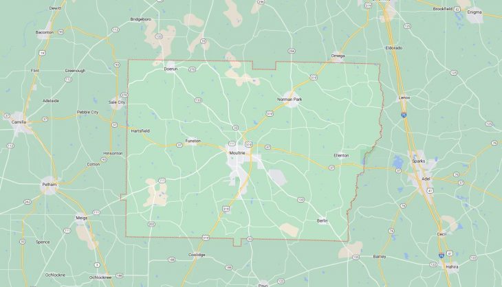
Cities and Towns in Colquitt County, Georgia
Founded in 1856, Colquitt County is one of 159 counties in the state of Georgia. Historically, Colquitt County was formed from Thomas and Lowndes counties. The city of Moultrie is the county seat. With FIPS code of 71, Colquitt County has a population of 45,812 and area of 552 square miles (1,430 km²).
List of all cities in Colquitt County, GA alphabetically
City/Town | Postal Code | Area Code |
Berlin, GA | 31722 | 229 |
Doerun, GA | 31744 | 229 |
Ellenton, GA | 31747 | 229 |
Funston, GA | 31753 | 229 |
Hartsfield, GA | 31756 | 229 |
Hartville, GA | 31756 | 229 |
Moultrie, GA | 31768 | 229 |
31776 | 229 | |
31788 | 229 | |
Moultrie Municipal Airport, GA | 31768 | 229 |
Norman Park, GA | 31771 | 229 |
Major Cities and Towns in Colquitt County, Georgia
Moultrie
Area, Population, Zip Codes, and Coordinates
- Area: 16.5 square miles
- Population: Approximately 14,000
- Zip Codes: 31768, 31776
- Latitude: 31.1799° N
- Longitude: 83.7884° W
City Location and History
Moultrie, the county seat of Colquitt County, is located in the southern part of Georgia, approximately 60 miles northeast of Tallahassee, Florida. The city was founded in 1859 and was named after General William Moultrie, a Revolutionary War hero. Moultrie quickly grew into an agricultural hub, with cotton being the primary crop. The arrival of the railroad in the late 19th century further spurred the city’s development, making it a key transportation and trade center for the region. Over the years, Moultrie diversified its economy, incorporating manufacturing and other industries. Today, the city is known for its historic downtown, beautiful architecture, and strong sense of community.
Major Schools and Landmarks
Moultrie is served by the Colquitt County School District, with Colquitt County High School being the primary educational institution. The city is also home to Southern Regional Technical College, which provides higher education and vocational training. Notable landmarks in Moultrie include the Colquitt County Courthouse, a historic building that is listed on the National Register of Historic Places, and the Moultrie Commercial Historic District, which features a variety of shops, restaurants, and cultural attractions. The Sunbelt Agricultural Exposition, held annually in Moultrie, is one of the largest farm shows in the United States, attracting visitors from across the country.
Berlin
Area, Population, Zip Codes, and Coordinates
- Area: 1.0 square miles
- Population: Approximately 550
- Zip Codes: 31722
- Latitude: 31.0671° N
- Longitude: 83.6207° W
City Location and History
Berlin is a small town located in the southeastern part of Colquitt County, Georgia. The town was incorporated in 1910 and was named after Berlin, Germany, reflecting the cultural influences of its early settlers. Berlin developed as an agricultural community, with farming being the primary occupation of its residents. The town’s location in the fertile plains of southeastern Georgia made it ideal for crop production, and agriculture remains central to its economy. Despite its small size, Berlin has maintained a strong sense of community and continues to celebrate its rural heritage.
Major Schools and Landmarks
Berlin is served by the Colquitt County School District, with students typically attending schools in nearby Moultrie. The town’s landmarks include the Berlin Community Center, which hosts various local events and activities, and several historic churches that reflect the town’s deep-rooted community values. The surrounding farmland and natural landscapes provide opportunities for outdoor activities such as hunting and fishing. Berlin’s small-town charm, agricultural roots, and close-knit community make it a peaceful place to live within Colquitt County.
Ellenton
Area, Population, Zip Codes, and Coordinates
- Area: 0.8 square miles
- Population: Approximately 280
- Zip Codes: 31747
- Latitude: 31.1716° N
- Longitude: 83.5849° W
City Location and History
Ellenton is a small town located in the northeastern part of Colquitt County, Georgia. The town was incorporated in 1970, although the area has been settled for much longer. Ellenton developed as a rural farming community, with its economy historically based on agriculture. The town’s location along Georgia State Route 133 provided vital access to nearby markets, contributing to its growth. Over the years, Ellenton has remained a small, quiet community, with a focus on maintaining its agricultural heritage and rural lifestyle.
Major Schools and Landmarks
Ellenton is served by the Colquitt County School District, with educational facilities located in nearby towns such as Moultrie. The town’s landmarks include several historic homes and buildings that reflect its rural heritage. The surrounding countryside offers opportunities for outdoor activities, including farming, hunting, and fishing. Ellenton’s small size, historical significance, and commitment to preserving its rural character make it a unique and charming community within Colquitt County.
Doerun
Area, Population, Zip Codes, and Coordinates
- Area: 1.9 square miles
- Population: Approximately 800
- Zip Codes: 31744
- Latitude: 31.3205° N
- Longitude: 83.9196° W
City Location and History
Doerun is a small town located in the northern part of Colquitt County, Georgia. The town was incorporated in 1901 and developed as an agricultural community, with cotton being the dominant crop in its early years. Doerun’s name is believed to be derived from the term “doer’s run,” reflecting the industrious spirit of its early settlers. The town grew steadily over the years, with agriculture remaining the backbone of its economy. Today, Doerun continues to be a rural community with a strong connection to its agricultural roots, offering a quiet and peaceful lifestyle.
Major Schools and Landmarks
Doerun is served by the Colquitt County School District, with Doerun Elementary School being a key educational institution in the town. The town’s landmarks include the historic Doerun United Methodist Church and several old homes that reflect its early 20th-century heritage. The Doerun Pitcherplant Bog Natural Area, located nearby, is a unique ecological site that attracts nature enthusiasts and researchers. Doerun’s blend of historical significance, rural charm, and natural beauty make it a distinctive community within Colquitt County.
Norman Park
Area, Population, Zip Codes, and Coordinates
- Area: 1.3 square miles
- Population: Approximately 1,000
- Zip Codes: 31771
- Latitude: 31.2693° N
- Longitude: 83.6860° W
City Location and History
Norman Park is a small town located in the central part of Colquitt County, Georgia. The town was incorporated in 1902 and was named after J.B. Norman, a local landowner who played a significant role in its early development. Norman Park grew as an agricultural community, with its economy centered on farming and related industries. The town’s location along the Georgia and Florida Railroad provided essential transportation links that supported its growth. Over the years, Norman Park has maintained its small-town charm and continues to be a close-knit community with strong ties to its agricultural heritage.
Major Schools and Landmarks
Norman Park is served by the Colquitt County School District, with Norman Park Elementary School being a key educational institution in the town. The town’s landmarks include several historic buildings and churches, as well as the former Norman Institute, a private school that operated from the early 1900s until the mid-20th century. The nearby Reed Bingham State Park offers outdoor recreational opportunities such as camping, fishing, and hiking. Norman Park’s combination of historical significance, educational heritage, and natural beauty makes it a unique and appealing community within Colquitt County.