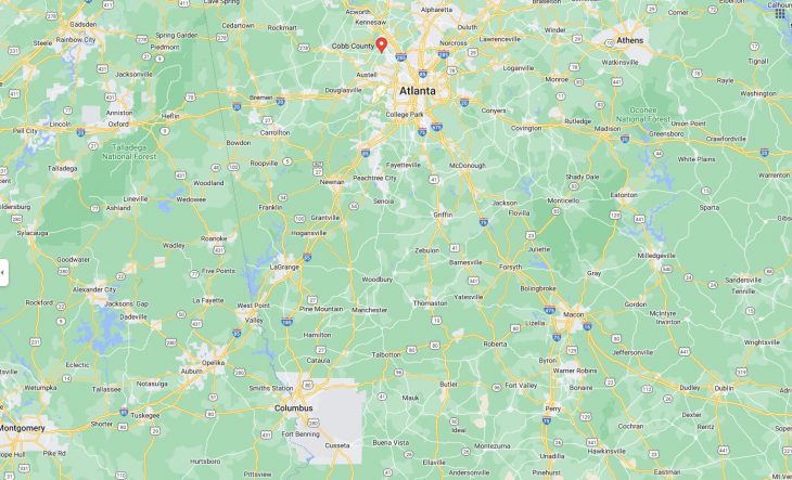
Cities and Towns in Cobb County, Georgia
Founded in 1832, Cobb County is one of 159 counties in the state of Georgia. Historically, Cobb County was formed from Cherokee County. The city of Marietta is the county seat. With FIPS code of 67, Cobb County has a population of 766,802 and area of 340 square miles (881 km²).
List of all cities in Cobb County, GA alphabetically
City/Town | Postal Code | Area Code |
Acworth, GA | 30101 | 770/678/470 |
Atlanta Naval Air Station, GA | 30060 | 770/678/470 |
Austell, GA | 30106 | 770/678/470 |
Austell, GA | 30168 | 770/678/470 |
Barrett Parkway, GA | 30144 | 770/678/470 |
Clarkdale, GA | 30111 | 770/678/470 |
Dobbins Air Force Base, GA | 30060 | 770/678/470 |
30069 | 770/678/470 | |
Kennesaw, GA | 30144 | 770/678/470 |
30152 | 770/678/470 | |
30156 | 770/678/470 | |
30160 | 770/678/470 | |
Lockheed, GA | 30063 | 770/678/470 |
Mableton, GA | 30126 | 770/678/470 |
Mar, GA | 30065 | 770/678/470 |
Marietta, GA | 30006 | 770/678/470 |
30007 | 770/678/470 | |
30008 | 770/678/470 | |
30060 | 770/678/470 | |
30061 | 770/678/470 | |
30062 | 770/678/470 | |
30063 | 770/678/470 | |
30064 | 770/678/470 | |
30065 | 770/678/470 | |
30066 | 770/678/470 | |
30067 | 770/678/470 | |
30068 | 770/678/470 | |
30069 | 770/678/470 | |
30090 | 770/678/470 | |
Mreta, GA | 30065 | 770/678/470 |
Oak Grove, GA | 30101 | 770/678/470 |
Powder Springs, GA | 30127 | 770/678/470 |
Smyrna, GA | 30080 | 770/678/470 |
30081 | 770/678/470 | |
30082 | 770/678/470 |
Major Cities and Towns in Cobb County, Georgia
Marietta
Area, Population, Zip Codes, and Coordinates
- Area: 23.5 square miles
- Population: Approximately 60,000
- Zip Codes: 30008, 30060, 30062, 30064, 30066, 30067, 30068
- Latitude: 33.9526° N
- Longitude: 84.5499° W
City Location and History
Marietta, the county seat of Cobb County, is located in the northwestern part of the Atlanta metropolitan area. Established in 1834, Marietta is one of the oldest cities in the region and has a rich history that includes a significant role during the Civil War. The city was a strategic location for the Confederate Army, and the Battle of Kennesaw Mountain was fought nearby in 1864. After the war, Marietta rebuilt and developed into a major industrial and commercial hub. Over the years, the city has preserved much of its historic charm, with numerous antebellum homes and buildings still standing. Today, Marietta is known for its vibrant community, historic downtown, and strong cultural scene.
Major Schools and Landmarks
Marietta is served by the Marietta City Schools and the Cobb County School District, with Marietta High School being one of the major educational institutions. Notable landmarks include the Marietta Square, which is the heart of the city’s historic district and hosts numerous events, shops, and restaurants. The Marietta Confederate Cemetery and the Gone with the Wind Museum are key attractions that draw history enthusiasts. Kennesaw Mountain National Battlefield Park, located just outside the city, offers hiking trails and historical exhibits related to the Civil War. Marietta’s blend of history, culture, and modern amenities makes it a vibrant and appealing place to live.
Smyrna
Area, Population, Zip Codes, and Coordinates
- Area: 15.4 square miles
- Population: Approximately 56,000
- Zip Codes: 30080, 30082
- Latitude: 33.8830° N
- Longitude: 84.5144° W
City Location and History
Smyrna is located in the southeastern part of Cobb County, just 10 miles northwest of downtown Atlanta. The city was incorporated in 1872 and has grown rapidly due to its proximity to Atlanta and its location along major transportation routes. Smyrna’s history is rooted in agriculture, but it transformed into a thriving suburban community in the 20th century. The city underwent significant redevelopment in the late 20th and early 21st centuries, particularly in its downtown area, known as the Smyrna Market Village. This revitalization has made Smyrna one of the most desirable places to live in the Atlanta metro area, with a strong sense of community and excellent amenities.
Major Schools and Landmarks
Smyrna is part of the Cobb County School District, with Campbell High School being a key educational institution in the city. The city’s major landmarks include the Smyrna Market Village, a mixed-use development that serves as the city’s social and commercial hub, and the Jonquil City Historical Trail, which highlights Smyrna’s history and cultural heritage. The Silver Comet Trail, a popular multi-use trail for biking and walking, runs through Smyrna, providing residents with recreational opportunities. Smyrna’s combination of suburban convenience, community-focused development, and access to green spaces makes it an attractive city for families and professionals.
Kennesaw
Area, Population, Zip Codes, and Coordinates
- Area: 9.8 square miles
- Population: Approximately 34,000
- Zip Codes: 30144, 30152
- Latitude: 34.0234° N
- Longitude: 84.6155° W
City Location and History
Kennesaw is located in the northern part of Cobb County, Georgia. The city was incorporated in 1887, though its history dates back to the early 19th century. Kennesaw is best known for its significant role in the Civil War, particularly the Battle of Kennesaw Mountain, which took place in 1864. The city’s name is derived from the Cherokee word “gahneesah,” meaning burial ground. After the Civil War, Kennesaw developed as a small railroad town, with its economy centered around agriculture and transportation. In recent decades, Kennesaw has experienced substantial growth, becoming a vibrant suburban community with a mix of historical sites and modern developments.
Major Schools and Landmarks
Kennesaw is served by the Cobb County School District, with Kennesaw Mountain High School being one of the major schools in the area. The city’s most notable landmark is the Kennesaw Mountain National Battlefield Park, which preserves the site of the Civil War battle and offers miles of hiking trails and historical exhibits. Another key attraction is the Southern Museum of Civil War and Locomotive History, which houses artifacts related to the Great Locomotive Chase. Swift-Cantrell Park, a large public park, provides recreational opportunities for residents. Kennesaw’s blend of historical significance, educational institutions, and recreational amenities makes it a dynamic place to live.
Acworth
Area, Population, Zip Codes, and Coordinates
- Area: 8.8 square miles
- Population: Approximately 23,000
- Zip Codes: 30101
- Latitude: 34.0659° N
- Longitude: 84.6769° W
City Location and History
Acworth is located in the northwestern part of Cobb County, along the shores of Lake Acworth and Lake Allatoona. The city was incorporated in 1860 and is known as the “Lake City” due to its proximity to these bodies of water. Acworth’s history is closely tied to the railroad, which brought growth and development to the area in the 19th century. The city’s economy was historically based on agriculture and trade, but it has evolved into a thriving suburban community with a strong emphasis on outdoor recreation and historic preservation. Acworth’s downtown area has been revitalized, preserving its historic charm while providing modern amenities.
Major Schools and Landmarks
Acworth is served by the Cobb County School District, with Allatoona High School being one of the prominent schools in the area. The city’s major landmarks include the historic downtown district, which features a variety of shops, restaurants, and the Acworth Depot. Lake Acworth and Lake Allatoona are key attractions, offering opportunities for boating, fishing, and other water sports. The Acworth Beach at Cauble Park is a popular spot for residents and visitors alike. The city’s commitment to preserving its history while fostering community and recreation makes Acworth a desirable place to live.
Powder Springs
Area, Population, Zip Codes, and Coordinates
- Area: 7.2 square miles
- Population: Approximately 15,000
- Zip Codes: 30127
- Latitude: 33.8595° N
- Longitude: 84.6838° W
City Location and History
Powder Springs is located in the southwestern part of Cobb County, Georgia. The city was originally known as Springville when it was founded in 1838, but it was renamed Powder Springs in 1859 due to the seven mineral springs in the area, which were believed to have healing properties. Powder Springs developed as a small agricultural community, with cotton being the primary crop. The arrival of the railroad in the late 19th century spurred growth, though the city remained relatively small compared to other nearby communities. Today, Powder Springs is a suburban city with a strong sense of community and a commitment to preserving its natural and historical resources.
Major Schools and Landmarks
Powder Springs is part of the Cobb County School District, with McEachern High School being a notable educational institution in the city. The city’s landmarks include the historic Powder Springs Park, which hosts community events and features walking trails and sports facilities. The Seven Springs Museum at the Bodiford House provides insights into the city’s history and the significance of its mineral springs. Powder Springs’ commitment to community engagement and its picturesque setting make it a charming and welcoming city within Cobb County.
Austell
Area, Population, Zip Codes, and Coordinates
- Area: 6.0 square miles
- Population: Approximately 7,000
- Zip Codes: 30106, 30168
- Latitude: 33.8126° N
- Longitude: 84.6341° W
City Location and History
Austell is located in the southwestern part of Cobb County, straddling the border with Douglas County. The city was founded in the late 19th century and was named after General Alfred Austell, a prominent banker and founder of the Atlanta National Bank. Austell’s growth was closely tied to the arrival of the railroad, which made the city a key transportation hub in the region. The city’s natural mineral springs, believed to have healing properties, also attracted visitors, contributing to its early development as a health resort. Today, Austell is a small suburban community with a rich history and a strong connection to the Atlanta metropolitan area.
Major Schools and Landmarks
Austell is served by both the Cobb County and Douglas County School Districts, with South Cobb High School being a significant educational institution for local students. The city’s landmarks include the historic downtown area, with its preserved 19th-century buildings, and the Sweetwater Creek State Park, which offers hiking trails, picnic areas, and the ruins of the New Manchester Manufacturing Company. Six Flags Over Georgia, one of the state’s largest amusement parks, is located just outside Austell and is a major attraction for residents and visitors. Austell’s blend of history, natural beauty, and proximity to major attractions makes it a unique and desirable place to live in Cobb County.