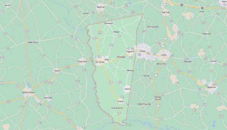
Cities and Towns in Montgomery County, Georgia

Founded in 1793, Montgomery County is one of 159 counties in the state of Georgia. Historically, Montgomery County was formed from Washington County. The city of Mount Vernon is the county seat. With FIPS code of 209, Montgomery County has a population of 8,653 and area of 245 square miles (635 km²).

List of all cities in Montgomery County, GA alphabetically

City/Town Postal Code Area Code
Ailey, GA 30410 912
Alston, GA 30412 912
Higgston, GA 30410 912
McGregor, GA 30410 912
Mount Vernon, GA 30445 912
Tarrytown, GA 30470 912
Uvalda, GA 30473 912

Major Cities and Towns in Montgomery County, Georgia

Mount Vernon

Area, Population, Zip Codes, and Coordinates

  • Area: 3.8 square miles
  • Population: Approximately 2,451 (2020 Census)
  • Zip Codes: 30445
  • Latitude and Longitude: 32.1790° N, 82.5953° W

Location and History

Mount Vernon is the county seat of Montgomery County, located in the southeastern part of Georgia. The city was founded in 1813 and named after George Washington’s Virginia estate, reflecting the early settlers’ admiration for the first U.S. president. Mount Vernon developed as a central hub for agriculture, with cotton being the primary crop during its early years. The city’s location on the Oconee River made it a key point for trade and transportation in the region. Over the years, Mount Vernon has maintained its historic charm, with a downtown area that features well-preserved buildings from the 19th and early 20th centuries. The city’s history is deeply intertwined with that of Montgomery County, serving as the center of local government and community life.

Major Schools and Landmarks

Mount Vernon is served by the Montgomery County School District, with Montgomery County High School being the primary educational institution. The school offers a range of academic and extracurricular programs, including sports, arts, and vocational training. Major landmarks in Mount Vernon include Brewton-Parker College, a private Christian college that has been a cornerstone of the community since its founding in 1904. The college offers undergraduate programs and plays a significant role in the cultural and educational life of the area. The Montgomery County Courthouse, built in 1907, is another key landmark, reflecting the city’s long history as the county seat. The downtown area, with its historic buildings and tree-lined streets, is a central gathering place for community events and festivals, including the annual Fall Festival.

Ailey

Area, Population, Zip Codes, and Coordinates

  • Area: 1.4 square miles
  • Population: Approximately 529 (2020 Census)
  • Zip Codes: 30410
  • Latitude and Longitude: 32.1893° N, 82.5687° W

Location and History

Ailey is a small city located just east of Mount Vernon in Montgomery County. The city was incorporated in 1890 and named after Reverend Ailey, a local minister who was instrumental in the town’s early development. Ailey grew as an agricultural community, with the surrounding fertile lands being used for cotton, corn, and tobacco farming. The arrival of the railroad in the late 19th century contributed to the town’s growth, making it an important stop for trade and transportation in the region. Despite its small size, Ailey has a rich history and has maintained its rural character, with a strong sense of community and a commitment to preserving its historical roots.

Major Schools and Landmarks

Ailey is part of the Montgomery County School District, with students attending schools in nearby Mount Vernon, including Montgomery County High School. The city itself does not have its own high school but benefits from the educational resources available in the county. Major landmarks in Ailey include the historic Ailey Methodist Church, which has been a central part of the community since the late 19th century. The church is known for its traditional architecture and active congregation. The nearby Brewton-Parker College in Mount Vernon also serves as a significant educational and cultural landmark for the residents of Ailey. The surrounding countryside offers scenic views of farmland and forests, providing opportunities for outdoor activities such as hiking, fishing, and birdwatching. Ailey’s annual Christmas parade is a popular event that brings the community together to celebrate the holiday season.

Uvalda

Area, Population, Zip Codes, and Coordinates

  • Area: 1.1 square miles
  • Population: Approximately 549 (2020 Census)
  • Zip Codes: 30473
  • Latitude and Longitude: 32.0335° N, 82.5083° W

Location and History

Uvalda is a small town located in the southern part of Montgomery County. The town was incorporated in 1911 and is believed to have been named after a Spanish or Native American word, though the exact origin is unclear. Uvalda developed as an agricultural community, with the timber and turpentine industries playing significant roles in its early economy. The town’s location near the Altamaha River contributed to its growth as a trade center, with the river providing a transportation route for goods. Over the years, Uvalda has maintained its small-town atmosphere, with a focus on preserving its rural heritage and community values.

Major Schools and Landmarks

Uvalda is part of the Montgomery County School District, with students attending schools in nearby towns such as Mount Vernon and Vidalia. The town does not have its own high school but is served by the county’s educational institutions. Major landmarks in Uvalda include the historic Uvalda Baptist Church, which has been a focal point of the community since its founding in the early 20th century. The church is known for its traditional services and strong community involvement. The surrounding area is characterized by its natural beauty, with the Altamaha River providing opportunities for boating, fishing, and exploring the local wildlife. The town’s proximity to the river has also made it a popular spot for outdoor enthusiasts and nature lovers. Uvalda’s annual Harvest Festival celebrates the town’s agricultural roots with food, crafts, and entertainment for all ages.

Tarrytown

Area, Population, Zip Codes, and Coordinates

  • Area: 1.0 square miles
  • Population: Approximately 87 (2020 Census)
  • Zip Codes: 30470
  • Latitude and Longitude: 32.1800° N, 82.4593° W

Location and History

Tarrytown is one of the smallest incorporated towns in Montgomery County, located in the eastern part of the county. The town was incorporated in 1912 and is believed to have been named after Tarrytown, New York, though the exact reason for the name is not well-documented. Tarrytown developed as a rural agricultural community, with farming being the primary industry. The town’s small population and remote location have helped it retain a quiet, rural atmosphere. Despite its small size, Tarrytown has a rich history and a close-knit community that values its traditions and rural way of life.

Major Schools and Landmarks

Tarrytown is part of the Montgomery County School District, with students attending schools in nearby Mount Vernon and Ailey, including Montgomery County High School. The town does not have its own schools but is well-served by the district’s educational resources. Major landmarks in Tarrytown include the Tarrytown Baptist Church, a historic church that has been a central part of the community since the town’s early days. The church is known for its traditional services and strong ties to the local community. The surrounding countryside, with its fields, forests, and streams, offers opportunities for outdoor activities such as hunting, fishing, and hiking. Tarrytown’s annual community gatherings and church events are key aspects of life in this small, rural town, bringing residents together to celebrate their shared heritage and values.

Map of Cities in Montgomery County, GA

Map of Cities in Montgomery County, GA