Where is Bahamas Located?
Where is Bahamas located on the map? Bahamas is an independent nation located in North America. Check out the following images to see location of Bahamas on maps.
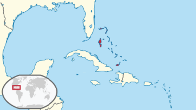
Bahamas Location in World Map
The Bahamas are in the red circle. The USA with Florida and Cuba are the closest states.
Location Information of The Bahamas
Latitude and Longitude
The Bahamas is a country consisting of a group of islands located in the Caribbean Sea, to the southeast of the United States. It lies north of Cuba and to the east of Florida. The geographical coordinates of The Bahamas are:
- Latitude: 25.0343° N
- Longitude: 77.3963° W
The Bahamas is an archipelago of over 700 islands and cays, with the majority of its landmass located in the Atlantic Ocean. The country’s strategic location between the U.S. and the Caribbean makes it a vital player in regional trade, tourism, and culture.
Capital City and Major Cities
- Capital City: NassauNassau, located on New Providence Island, is the capital and largest city of The Bahamas. It is the political, cultural, and economic heart of the country. Nassau is known for its colonial architecture, vibrant markets, and lively arts scene. Its waterfront area is a bustling hub with historic buildings such as the Parliament Square, Government House, and the Pirates Museum. Nassau also serves as the gateway for tourists visiting the islands, with the city’s port welcoming large cruise ships from around the world.
- Major Cities:
- Freeport – Located on Grand Bahama Island, Freeport is the second-largest city in The Bahamas and an important industrial and commercial center. Freeport is known for its duty-free shopping and proximity to Lucaya Beach, offering visitors access to both modern amenities and natural beauty.
- Abaco – A group of islands in the northern Bahamas, the Abaco Islands are known for their sailing opportunities, charming colonial architecture, and laid-back lifestyle. Marsh Harbour is the largest town on the islands.
- Harbour Island – Known for its pink sand beaches and vibrant history, Harbour Island is a small yet popular destination for tourists. Its quaint and peaceful atmosphere makes it a favorite among vacationers.
- Andros – The largest island in The Bahamas, Andros is known for its natural beauty, including tropical forests, extensive wetlands, and the Andros Barrier Reef. The island’s population is sparse, but it remains a prime location for eco-tourism and nature-based activities.
- Exuma – This district consists of over 365 islands, with George Town as the capital. The Exumas are famous for their crystal-clear waters, serene beaches, and marine life, making them a prime spot for boating, fishing, and relaxation.
Time Zone
The Bahamas operates in the Eastern Standard Time (EST) zone, which is UTC -5 during the standard time. The country observes Daylight Saving Time (DST) from March to November, switching to Eastern Daylight Time (EDT), which is UTC -4. This time zone alignment is shared with the U.S. East Coast, making it easy for travelers to adapt when crossing between the two regions.
Climate
The climate in The Bahamas is tropical, characterized by mild winters and warm summers. The country’s geographical location results in a combination of subtropical and tropical climate conditions, influenced by both the Atlantic Ocean and the Caribbean Sea.
- Tropical Climate: The climate is warm year-round, with temperatures averaging around 77°F (25°C) to 88°F (31°C) during the summer months and dropping to 65°F (18°C) to 75°F (24°C) in the winter. The summer months can be hot and humid, while winters are generally mild and pleasant.
- Rainfall: The Bahamas experiences a relatively low amount of rainfall, averaging about 50 to 60 inches (1,270–1,520 mm) per year. Most of the rainfall occurs during the wet season, which lasts from May to October. The dry season, from November to April, is the peak tourist season due to the pleasant weather.
- Hurricane Season: The hurricane season in The Bahamas runs from June to November. The islands are susceptible to tropical storms and hurricanes, though many islands are well-prepared with infrastructure and disaster management systems to handle these events.
- Breezes: The trade winds that blow from the east help moderate the heat, making the climate more bearable during the hotter months. Coastal areas tend to be more humid, while inland areas are generally drier.
The tropical climate of The Bahamas makes it a popular year-round destination for beach vacations, water sports, and other outdoor activities.
Economic Status
The Bahamas has a highly developed economy that relies heavily on tourism, financial services, and offshore banking. Its stable political environment, strategic location, and natural resources contribute to its economic success.
- Tourism: Tourism is by far the most important sector in The Bahamas, contributing about 50% of the GDP and accounting for a significant portion of employment. The country is known for its beautiful beaches, luxury resorts, vibrant marine life, and world-class diving and snorkeling spots. Nassau and Freeport are the most popular destinations for international tourists, but islands such as Exuma, Harbour Island, and Abaco also attract significant numbers of visitors. Cruise ship tourism also plays an essential role, with The Bahamas being a frequent stop on Caribbean itineraries.
- Financial Services and Banking: The Bahamas has established itself as a leading offshore financial center, offering banking, investment, and insurance services. The country’s tax laws, which include no income tax, capital gains tax, or inheritance tax, have made it an attractive destination for international businesses and wealthy individuals. The Bahamian government continues to regulate and oversee financial activities to ensure the integrity of its financial system.
- Agriculture and Fishing: Although tourism and finance dominate the economy, agriculture and fishing still contribute to the livelihoods of many Bahamians. Fishing, particularly for lobster and conch, is an important industry, as is agriculture, with crops such as sugarcane, citrus fruits, and vegetables being grown on the islands. However, the agriculture sector is limited by the islands’ small land area and lack of freshwater resources.
- Real Estate and Construction: The real estate sector in The Bahamas has seen substantial growth, especially in resort developments and luxury housing. The demand for second homes and vacation properties from foreign buyers has contributed to this expansion. Additionally, large-scale construction projects, including resorts, marinas, and residential communities, have driven economic activity.
- Challenges: Despite its high per capita income and developed infrastructure, The Bahamas faces challenges such as income inequality, reliance on tourism, and vulnerability to natural disasters, including hurricanes. The country is also dependent on the import of most goods, which can lead to higher costs and trade imbalances.
Tourist Attractions
The Bahamas offers a wealth of natural beauty, historical sites, and activities that attract millions of visitors each year. Some of the country’s top tourist attractions include:
- Nassau: The capital city is home to various cultural and historic landmarks, such as the Pirates Museum, The Queen’s Staircase, and the National Art Gallery of The Bahamas. Visitors can explore Bay Street for shopping, enjoy local cuisine, or experience the nightlife in the vibrant downtown area.
- Exuma Cays: Known for their pristine beaches, crystal-clear waters, and swimming pigs, the Exuma Cays are a popular destination for boating, snorkeling, and diving. The area is also known for its luxury resorts and exclusive private islands.
- Blue Hole: The Bahamas is home to several blue holes, which are underwater sinkholes that attract divers from around the world. Dean’s Blue Hole near Long Island is the deepest known blue hole in the world, reaching depths of over 600 feet (183 meters).
- Atlantis Resort: Located on Paradise Island, Atlantis Resort is one of the largest and most famous resorts in The Bahamas. It offers a massive water park, marine habitats, a casino, luxury accommodations, and a variety of entertainment options.
- Harbour Island: Known for its famous Pink Sand Beach, Harbour Island is a popular destination for relaxation and luxury retreats. The island’s colonial-style architecture, vibrant local culture, and charming atmosphere make it a unique destination.
- The Exuma Land and Sea Park: This protected marine area is one of the world’s oldest marine parks. It spans over 176 square miles (455 square kilometers) and is home to diverse marine life, including coral reefs, sharks, rays, and sea turtles.
- Grand Bahama Island: Home to the city of Freeport, Grand Bahama is known for its beautiful beaches, diving sites, and nature reserves. Popular spots include Lucayan National Park, with its underwater caves and pristine beaches, and Gold Rock Beach, a favorite among photographers.
- Abaco Islands: The Abacos offer a charming, relaxed atmosphere, with vibrant colonial architecture, fantastic sailing opportunities, and beautiful beaches. Marsh Harbour is the largest town in the region and serves as a hub for exploring the surrounding islands.
Visa Requirements for U.S. Citizens
U.S. citizens visiting The Bahamas for tourism purposes for 90 days or less do not require a visa. However, there are some key requirements for entry:
- Passport: U.S. citizens must have a valid U.S. passport with at least six months of validity beyond their intended departure date from The Bahamas.
- Return or Onward Ticket: U.S. citizens must provide proof of a return or onward travel ticket upon arrival.
- Proof of Sufficient Funds: Travelers may be asked to show proof of sufficient funds for their stay, including hotel reservations or confirmation of travel arrangements.
- Customs Declaration: Upon arrival, travelers must complete a customs declaration form, which asks about items being brought into the country.
For travelers who wish to stay longer than 90 days, work, or study in The Bahamas, a visa or permit will be required, and the appropriate application must be made through the Bahamian consulate or embassy.
Distance to Major U.S. Cities
The approximate distances from Nassau, The Bahamas, to major U.S. cities are as follows:
- Distance to New York City: The distance from Nassau to New York City is approximately 1,100 miles (1,770 kilometers). Flights typically take about 2.5 to 3 hours.
- Distance to Los Angeles: The distance from Nassau to Los Angeles is approximately 2,500 miles (4,000 kilometers). Flights typically take about 4.5 to 5 hours, with layovers in major U.S. cities such as Miami or Fort Lauderdale.
Bahamas Facts
| Size | 13,939 km² |
| Residents | 385,000 |
| Language | English |
| Capital | Nassau |
| Longest river | – |
| Highest mountain | Mount Alvernia (63 m) |
| Currency | Bahamian dollars |


