Where is Madagascar Located?
Where is Madagascar located on the map? Madagascar is an independent nation located in Eastern Africa. Check out the following images to see location of Madagascar on maps.
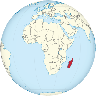
Madagascar Location in World Map
With an area of 587,295 square kilometers, Madagascar is the fourth largest island in the world and the second largest island nation after Indonesia. Madagascar is located off the east coast of Africa, “opposite” Mozambique in the middle of the Indian Ocean . Madagascar is separated from Mozambique by the Strait of Mozambique. If you were to drive around the island, you would have covered more than 4,800 kilometers.
Madagascar runs through a plateau with an average height of 1100 meters. You reach the highest point with the Maromokotro, a 2876 meter high mountain in the north of the country. There are five regions in Madagascar. These are the east coast, the Tsaratanana massif in the north, the central highlands, the west coast and the southwest. The climate differs in the regions. Especially the north of the island is very rugged and there are many bays here.
One often hears the term “red island” for Madagascar. The soils of Madagascar are often red and that’s where the name comes from.
Madagascar is located in the Indian Ocean.
Location Information of Madagascar
Latitude and Longitude
Madagascar is an island nation located in the Indian Ocean, off the southeastern coast of Africa. It lies at approximately 18.7669° S latitude and 46.8691° E longitude. Madagascar is the fourth largest island in the world, covering an area of about 587,000 square kilometers (226,658 square miles), and it is situated around 400 kilometers (250 miles) off the eastern coast of mainland Africa, separated by the Mozambique Channel.
This strategic location places Madagascar in a unique ecological zone, with its flora and fauna being among the most distinctive in the world, as the island has been isolated for millions of years.
Capital City and Major Cities
The capital city of Madagascar is Antananarivo, often abbreviated as Tana, which serves as the country’s political, economic, and cultural center. Located in the central highlands of Madagascar, it is the largest city in the country, with a population of over 1.6 million people. Antananarivo is known for its historical architecture, busy markets, and cultural heritage, including the Royal Palace and Analakely Market.
Other significant cities include:
- Toamasina (Tamatave) – The second-largest city and the main port of Madagascar, located on the eastern coast. Toamasina is vital for trade and commerce, as it handles most of the country’s imports and exports.
- Antsirabe – Situated in the central highlands, Antsirabe is known for its thermal springs and scenic surroundings. It is an important industrial center, particularly for the production of textiles and processed foods.
- Mahajanga (Majunga) – Located on the northwest coast, Mahajanga is a major port city and a popular destination for its beautiful beaches and unique culture.
- Fianarantsoa – Located in the southern part of the island, Fianarantsoa is a key administrative and educational hub, with several important universities and institutions of higher learning.
- Tuléar (Toliara) – A coastal city in the southwest of Madagascar, known for its proximity to unique natural attractions like Isalo National Park and its connection to the fishing and salt industries.
Madagascar’s cities are diverse in terms of culture and economy, with urbanization occurring mainly around the central highlands and coastal areas.
Time Zone
Madagascar operates on East Africa Time (EAT), which is UTC+3 year-round. The country does not observe daylight saving time, so the time remains constant throughout the year. This time zone aligns with several other East African nations, including Kenya, Tanzania, and Ethiopia.
The absence of daylight saving time helps to simplify time management for travelers, as there is no need to adjust clocks seasonally.
Climate
Madagascar has a tropical climate, but it varies depending on the region due to the island’s diverse topography, which includes rainforests, mountains, plateaus, and coastal plains. The climate can be classified into two primary zones: wet and dry.
- Coastal Areas: The coastal regions of Madagascar, including cities like Toamasina and Mahajanga, experience a tropical climate with hot, humid conditions. The wet season runs from November to April, bringing heavy rainfall, while the dry season, from May to October, is cooler and less humid. Average temperatures in these regions range from 25°C to 35°C (77°F to 95°F).
- Highlands: The central highlands, including Antananarivo and Antsirabe, experience more moderate temperatures. Summers (November to March) can be warm, with daytime temperatures averaging 20°C to 28°C (68°F to 82°F), while winters (June to September) can be chilly, with temperatures dipping as low as 5°C to 10°C (41°F to 50°F). This region also experiences a distinct wet season, with heavier rains from December to March.
- Southern and Western Regions: These areas, including cities like Tuléar, have a semi-arid climate with much lower rainfall. Temperatures in these regions can soar during the summer, often reaching 35°C to 40°C (95°F to 104°F). These areas are more drought-prone and have sparse vegetation compared to the rest of the island.
- Rainforests and Eastern Regions: The eastern rainforests, such as those around Andasibe-Mantadia National Park, are among the wettest parts of Madagascar, with frequent rainfall and high humidity throughout the year.
Overall, Madagascar has a very diverse climate, allowing for a variety of ecosystems to thrive across the island, from tropical rainforests to arid deserts and dry plains.
Economic Status
Madagascar is a developing economy that primarily relies on agriculture, mining, and natural resources. Despite its rich biodiversity and natural resources, the country faces significant economic challenges, including poverty, political instability, and infrastructure issues.
- Agriculture: Agriculture is the backbone of Madagascar’s economy, employing a large portion of the population. The country is a major exporter of products like vanilla, cloves, lychees, coffee, and cocoa. Rice is the staple food, and Madagascar produces large quantities, although it still imports some to meet demand. Fishing is also important, particularly tuna and shrimp, which are key exports.
- Mining: Madagascar is rich in minerals, and mining plays a growing role in the economy. The island has significant deposits of nickel, cobalt, gold, and sapphire. The mining industry, however, has been a source of both economic growth and environmental challenges, as unregulated mining and deforestation have caused significant damage to ecosystems.
- Tourism: Madagascar’s unique biodiversity is a major draw for tourists. Visitors come to explore its national parks, wildlife, and beaches. The country’s endemic species, such as lemurs, chameleons, and baobab trees, make it a popular destination for eco-tourism. The Avenue of the Baobabs and Nosy Be island are among the most visited spots.
- Manufacturing and Services: Manufacturing in Madagascar is less developed, but the country produces textiles, processed foods, and small-scale industrial products. The services sector is growing, with areas like telecommunications, finance, and retail expanding as urbanization increases.
- Foreign Aid and Debt: Madagascar is heavily dependent on foreign aid and loans to sustain its infrastructure and development projects. The country also faces substantial external debt, which constrains its economic growth.
Despite the economic challenges, Madagascar’s rich natural resources and tourism potential offer significant opportunities for future development.
Tourist Attractions
Madagascar is renowned for its unique ecosystems, biodiversity, and cultural heritage, offering a wide range of attractions for nature lovers, adventure tourists, and those interested in history and culture. Some of the top tourist destinations include:
1. Avenue of the Baobabs
The Avenue of the Baobabs is one of the most iconic natural landmarks in Madagascar. This striking stretch of dirt road is lined with towering baobab trees, some of which are over 1,000 years old. The trees create a dramatic, almost otherworldly landscape, making it one of the most photographed locations on the island.
2. Nosy Be
Nosy Be is a tropical island off the northwest coast of Madagascar, known for its beautiful beaches, crystal-clear waters, and diverse marine life. It is a popular destination for scuba diving, snorkeling, and exploring the nearby islands. Nosy Komba and Nosy Tanikely are famous for their natural beauty and opportunities to see lemurs and other wildlife.
3. Andasibe-Mantadia National Park
Located in the eastern part of Madagascar, this national park is one of the best places to see the indri, the largest living lemur. The park is home to lush rainforests, numerous species of birds, reptiles, and amphibians, and offers guided hikes through its diverse habitats.
4. Isalo National Park
Known for its dramatic sandstone formations, deep canyons, and unique plant life, Isalo National Park is one of Madagascar’s most famous natural attractions. It is also home to various species of lemurs, including the ring-tailed lemur. The park’s swimming holes provide visitors with the opportunity to cool off in crystal-clear water.
5. Tsingy de Bemaraha National Park
This UNESCO World Heritage Site is famous for its Tsingy formations – sharp, needle-like limestone formations that create a labyrinth of jagged peaks and gorges. The park is home to a variety of species, including lemurs and birds, and offers unique hiking opportunities.
6. Royal Hill of Ambohimanga
This historic site, located near Antananarivo, is a UNESCO World Heritage Site and one of the most important places in Malagasy culture. The Royal Hill of Ambohimanga was once a royal capital and is considered a sacred place by the Malagasy people. The site includes a palace, a royal tomb, and beautiful views of the surrounding area.
Visa Requirements for U.S. Citizens
U.S. citizens need a visa to enter Madagascar, which can be obtained either on arrival or through the Malagasy embassy prior to travel. The tourist visa on arrival is available for stays of up to 30 days, and it can be extended for an additional 30 days. A passport with at least six months of validity beyond the date of entry is required.
There are also specific visa fees that vary depending on the length of stay and the visa type. It is recommended to check the current requirements before traveling.
Distance to New York City and Los Angeles
- Distance to New York City: The distance from Antananarivo to New York City is approximately 16,000 kilometers (9,940 miles). A flight typically takes around 20-24 hours with at least one layover, as there are no direct flights.
- Distance to Los Angeles: The distance from Antananarivo to Los Angeles is about 17,000 kilometers (10,563 miles). Flights typically take around 21-25 hours, depending on layovers, as there are no direct routes.
Madagascar Facts
| Size | 587,295 km² |
| Residents | 28.188 million |
| Languages | Malagasy and French |
| Capital | Antananarivo |
| Longest river | Mangoky (564 km) |
| Highest mountain | Maromokotro (2,876 m) |
| Currency | Ariary |


