Kde se nachází Eritrea?
Kde se Eritrea nachází na mapě? Eritrea je nezávislý stát nacházející se ve východní Africe. Podívejte se na následující obrázky, kde najdete umístění Eritrey na mapě.
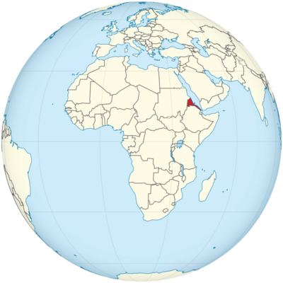
Poloha Eritreje na mapě světa
Eritrea leží u Rudého moře.
Informace o poloze Eritreje
Eritrea je země nacházející se v oblasti Afrického rohu, na pobřeží Rudého moře. Navzdory své relativně malé rozloze má Eritrea rozmanité kulturní dědictví a jedinečnou geopolitickou polohu. Země hraničí se Súdánem na západě, Etiopií na jihu a Džibutskem na jihovýchodě. Eritrejské pobřeží podél Rudého moře hraje klíčovou roli v její ekonomice a poskytuje přístup k důležitým námořním trasám, které spojují Evropu, Asii a Blízký východ.
Zeměpisná šířka a délka
Eritrea se nachází přibližně mezi 12° severní a 18° severní šířky a 36° východní a 43° východní délky. Díky tomu se Eritrea nachází v severovýchodní části Afriky a hraničí s Rudým mořem. Geografická poloha Eritreje ovlivňuje její klima, obchodní cesty a sociální a kulturní výměnu se sousedními zeměmi.
- Zeměpisná šířka: Eritrea leží mezi 12° severní šířky na jihu a 18° severní šířky na severu. Země se rozkládá v několika stupních zeměpisné šířky, což znamená, že má různá klimatická pásma od pouště až po mírnější a hornaté oblasti. Její nejjižnější bod se nachází blízko hranice s Etiopií, zatímco její nejsevernější bod leží blízko hranice se Súdánem.
- Zeměpisná délka: Eritrea se rozkládá od 36° východní délky do 43° východní délky a pokrývá jak pobřežní oblast podél Rudého moře, tak i vnitrozemské horské oblasti. Hlavní město Asmara se nachází poblíž 38° východní délky v centrální vysočině, zatímco pobřeží je blíže k 43° východní délky.
Hlavní město a velká města
Hlavní město Eritreje, Asmara, slouží jako politické, ekonomické a kulturní centrum země. V zemi se nachází několik dalších významných měst, která hrají zásadní roli v regionálním rozvoji Eritreje.
- Asmara: Asmara, located at an altitude of 2,325 meters (7,628 feet) above sea level in the central highlands, is known for its stunning Italian colonial architecture, which has earned it a place as a UNESCO World Heritage Site. The city has a rich cultural history, and its historic buildings, such as the Asmara Cathedral, Fiat Tagliero Building, and Palazzo del Governo, reflect a blend of Eritrean, Italian, and modernist styles. Asmara is also the country’s center of governance, with the government buildings, foreign embassies, and international organizations based in the city. It is a city of contrast, where the development of the 20th century meets traditional African heritage.
- Massawa: Located on the Red Sea coast, Massawa is Eritrea’s primary port and has historically been an important trade hub due to its proximity to the sea. Massawa is known for its strategic location and has a long history, including Ottoman and Italian influences. The city is renowned for its old Ottoman architecture, forts, and coastal resorts. It also serves as the gateway for imports and exports, and its port is essential for Eritrea’s economy.
- Keren: Keren is the second-largest city in Eritrea, located about 91 kilometers (57 miles) north of Asmara. Situated at an altitude of 1,300 meters (4,265 feet), Keren is a commercial and agricultural center. The city is known for its rich cultural diversity, as it is home to various ethnic groups, including the Bilen, Tigrinya, and Rashaida peoples. Keren is also known for its picturesque landscapes, including nearby mountains, and its historical significance as a key site during the Eritrean War for Independence.
- Dekemhare: Located to the south of Asmara, Dekemhare is an important city in Eritrea’s southern highlands. It is primarily known for its role in agriculture, with fertile soil supporting crops such as wheat, barley, and corn. Dekemhare is also a regional administrative center and an essential point of connection between Eritrea’s capital and the southern regions of the country.
- Tessenei: Located in the western part of Eritrea, Tessenei is a major town near the border with Sudan. It is an important trading town with links to Sudanese markets, and it serves as a transit point for goods moving between Eritrea and Sudan.
- Mendefera: Mendefera, located just south of Asmara, is another important city in Eritrea. It serves as the capital of the Southern Red Sea Region and is a significant regional administrative and commercial center. The city is known for its scenic views of surrounding hills and valleys, with agriculture being the mainstay of the local economy.
Time Zone
Eritrea operates on East Africa Time (EAT), which is UTC +3:00 year-round. Eritrea does not observe daylight saving time, meaning the country remains at UTC +3:00 throughout the year, in line with several other East African nations such as Ethiopia, Kenya, and Tanzania. This time zone position places Eritrea ahead of many European countries and significantly ahead of those in North America.
- Standard Time: As part of the East Africa Time Zone, Eritrea shares its time with countries like Somalia, Uganda, and Djibouti. There is no shift for daylight saving, meaning the time stays constant throughout the year, making it easier for business and communication across East Africa.
Climate
Eritrea’s climate varies significantly due to the country’s diverse geography, which includes coastal plains, mountainous highlands, and desert regions. The climate in Eritrea can be described as a mix of arid, semi-arid, and temperate, with variations based on elevation.
- Coastal Areas (Massawa): The coastal regions of Eritrea, including cities like Massawa, have a hot desert climate, with high temperatures year-round, typically exceeding 30°C (86°F) in the summer. The humidity along the Red Sea coast is high, especially during the rainy season from July to September. Winters in these regions are relatively mild, with daytime temperatures around 25°C (77°F).
- Highland Areas (Asmara, Keren): The central highlands, where cities like Asmara and Keren are located, have a more temperate climate due to their higher elevation. These regions experience cooler temperatures, ranging from 15°C to 25°C (59°F to 77°F) during the summer. Winters can be chilly, with temperatures sometimes dropping to 0°C (32°F), especially in the evenings. Rainfall is moderate, with the wet season occurring from June to September.
- Lowland Desert (Southern Eritrea): Eritrea’s lowland desert regions, especially in the south and east, are characterized by extremely hot and dry conditions. Temperatures in these areas can reach 40°C (104°F) or higher during the summer months, and rainfall is scarce. The dry season extends for much of the year, with the occasional short burst of rain during the wet season.
- Rainy Seasons: Eritrea experiences two rainy seasons: the main rainy season from June to September and a shorter rainy season in the spring from March to May. The rainy season is more pronounced in the highland regions and varies in intensity across the country.
Economic Status
Eritrea’s economy is largely based on agriculture, mining, and services. The country has faced significant challenges due to its history of conflict, international sanctions, and limited natural resources. Despite these challenges, Eritrea’s government has made efforts to diversify the economy, focusing on infrastructure development and exploitation of the country’s mineral resources.
- Agriculture: Agriculture is the backbone of Eritrea’s economy, employing a large portion of the population. The main crops grown include cereals such as teff, wheat, corn, and barley. Additionally, livestock farming plays a significant role in the rural economy, with cattle, goats, and sheep being the primary animals raised. The highland regions are particularly suited to farming, while the lowlands rely more on pastoralism. Droughts and erratic rainfall, however, often threaten agricultural productivity.
- Mining: Eritrea has significant mineral resources, including deposits of gold, zinc, copper, and potash. The mining sector has seen investment from international companies, particularly in gold and copper extraction. The Bisha Mine, located in the western part of Eritrea, is one of the country’s most important mining projects and has been a key contributor to export revenues. Eritrea is working to increase mining exports to bolster its economic growth.
- Manufacturing: The manufacturing sector in Eritrea is still in its early stages, with textiles, construction materials, and food processing being the primary industries. The government has emphasized the need to develop industrial capacities, though challenges such as power shortages, limited infrastructure, and political isolation have hindered rapid growth.
- Trade and Investment: Eritrea’s economy has faced significant constraints due to its isolation from international financial institutions and the limited flow of foreign direct investment (FDI). The country is heavily dependent on imports for manufactured goods, machinery, and petroleum. However, Eritrea’s access to the Red Sea gives it an advantage in terms of trade routes, particularly with countries in the Middle East and Asia.
- Challenges: Eritrea’s economy continues to be hindered by political isolation, limited infrastructure, and a lack of foreign investment. The country has also struggled with high unemployment and poverty rates, particularly in rural areas. Ongoing tensions with neighboring countries, such as Ethiopia and Djibouti, further complicate Eritrea’s efforts to achieve economic stability.
Tourist Attractions
Eritrea has a wealth of untapped potential in the tourism sector. The country’s blend of historical sites, stunning landscapes, and coastal beauty offers opportunities for a wide range of tourism experiences.
- Asmara’s Italian Colonial Architecture: Asmara is a key destination for those interested in architecture and history. The city’s unique Italian colonial buildings, such as the Fiat Tagliero Building, Asmara Cathedral, and Opera House, showcase a fascinating fusion of modernist and traditional designs.
- Massawa: The coastal city of Massawa is famous for its Ottoman and Italian colonial-era buildings. The old harbor, forts, and beach resorts offer a historical and recreational experience. Visitors can also take boat trips on the Red Sea, exploring nearby islands and enjoying the crystal-clear waters.
- Dahlak Archipelago: Off the coast of Massawa lies the Dahlak Archipelago, a group of islands known for their pristine beaches, coral reefs, and marine life. The islands are largely uninhabited, making them an ideal spot for scuba diving, snorkeling, and relaxation.
- Keren: Keren, located in the highlands, is known for its beautiful natural landscapes and historical significance. The Keren War Cemetery, dedicated to soldiers of the British and Commonwealth forces, is a poignant site. Additionally, visitors can explore the surrounding mountains, which offer hiking and wildlife-watching opportunities.
- Malebná oblast Filfil: Malebná oblast Filfil, která se nachází v jižní Eritreji, nabízí úchvatné výhledy na hornatý terén a je domovem unikátní divoké zvěře, včetně endemických druhů ptáků a rostlin. Je to skvělé místo pro pěší turistiku a pozorování ptáků.
Vízová povinnost pro občany USA
Občané USA cestující do Eritreje musí před příjezdem získat vízum. Země nemá systém víz po příjezdu, takže cestující musí o vízum požádat prostřednictvím eritrejského velvyslanectví nebo konzulátu.
- Turistické vízum: Občané USA musí požádat o turistické vízum prostřednictvím eritrejského velvyslanectví. Proces obvykle vyžaduje předložení cestovního pasu, vyplněného formuláře žádosti o vízum a dokladu o cestovních plánech. Vízum je obvykle platné 30 dní a lze jej během pobytu v Eritreji prodloužit.
- Obchodní vízum: Občané USA, kteří plánují cestu do Eritreje za obchodními účely, musí požádat o obchodní vízum, které vyžaduje pozvání od eritrejské společnosti nebo organizace.
Vzdálenost do New Yorku a Los Angeles
- Vzdálenost do New Yorku: Vzdálenost z Asmary, hlavního města Eritreje, do New Yorku je přibližně 7 500 mil (12 000 kilometrů). Přímé lety obvykle trvají kolem 14 hodin.
- Vzdálenost do Los Angeles: Vzdálenost z Asmary do Los Angeles je přibližně 8 200 mil (13 200 kilometrů). Lety obvykle trvají 15–16 hodin v závislosti na počtu mezipřistání.
Fakta o Eritreji
| Velikost | 121 100 km² |
| Obyvatelé | 5,86 milionu |
| Jazyky | Tigriňština a arabština |
| Kapitál | Asmara |
| Nejdelší řeka | Barka (500 km, ale jen několik měsíců v roce) |
| Nejvyšší hora | Soira (3 018 m) |
| Měna | Nakfa |


