Where is Grenada Located?
Where is Grenada located on the map? Grenada is an independent nation located in North America. Check out the following images to see location of Grenada on maps.
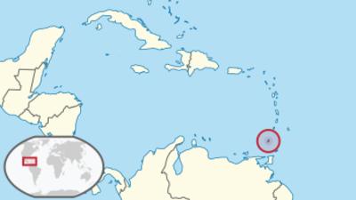
Grenada Location in World Map
Location Information of Grenada
Grenada is an island nation located in the southeastern Caribbean Sea, part of the Lesser Antilles archipelago. Known as the “Island of Spice” due to its production of nutmeg and other spices, Grenada is a popular destination for tourists and offers a rich cultural heritage, diverse landscapes, and beautiful beaches.
Latitude and Longitude
Grenada is situated at approximately 12.1167° N latitude and 61.6500° W longitude. The island lies to the north of Venezuela, and its geographical position places it within the tropical zone, resulting in a warm climate year-round. Grenada is located about 100 miles (160 kilometers) north of Trinidad and Tobago and around 250 miles (400 kilometers) south of Saint Lucia.
Capital City and Major Cities
St. George’s (Capital City)
The capital and largest city of Grenada is St. George’s, located on the southwestern coast of the island. St. George’s is considered one of the most picturesque cities in the Caribbean, with its natural harbor surrounded by hills and colorful buildings. It is the political, cultural, and economic center of the island.
- Harbor and Waterfront: The city is known for its Carenage, a picturesque horseshoe-shaped harbor surrounded by historical buildings and offering stunning views of the sea. The harbor is lined with shops, restaurants, and cafes, making it a popular spot for both locals and tourists.
- Historical Significance: St. George’s is rich in colonial architecture, including the Fort George, which overlooks the harbor. The city also features the National Museum of Grenada, which showcases the island’s history, art, and culture.
- Cultural Hub: The capital hosts various cultural events throughout the year, including Carnival, which is a significant celebration of Grenadian music, dance, and traditions.
Major Cities
- Gouyave: Located on the west coast of the island, Gouyave is Grenada’s second-largest town. Known for its fishing industry, Gouyave is a hub for seafood production and is also famous for its Friday night fish fry, a vibrant event where locals and tourists enjoy fresh seafood and music.
- Grenville: Situated on the eastern coast of the island, Grenville is the third-largest town in Grenada. It is an important agricultural center, where farmers bring their produce to sell at the town’s markets. Grenville is also known for its beautiful scenery and is a gateway to some of the island’s lush rainforests and hiking trails.
- Victoria: A small town located on the southwestern side of the island, Victoria is known for its close proximity to some of Grenada’s finest beaches. It serves as an important regional center for the island’s tourism industry and features several historical landmarks.
Time Zone
Grenada follows Atlantic Standard Time (AST), which is UTC -4:00. The island does not observe Daylight Saving Time, meaning the time remains consistent throughout the year. This time zone is shared with other Caribbean nations, including Barbados and Saint Lucia.
Climate
Grenada has a tropical climate, characterized by two main seasons: the wet season and the dry season. The island’s relatively small size and its geographical location give it a varied climate, with coastal areas experiencing warm temperatures and occasional rain, while the higher elevations can be cooler.
Wet Season (June to November)
The wet season in Grenada typically lasts from June to November, with the highest rainfall occurring between August and October. During this time, the island is vulnerable to tropical storms and hurricanes, although Grenada is less frequently affected by hurricanes compared to other Caribbean islands. The rains are generally short and intense, usually occurring in the afternoon or evening.
Dry Season (December to May)
The dry season in Grenada extends from December to May. During this period, the weather is more predictable and generally sunny, with lower humidity and very little rainfall. This season is considered the best time to visit the island, as the weather is perfect for outdoor activities like hiking, beach lounging, and water sports.
Temperature
Grenada’s temperatures remain warm throughout the year, ranging between 77°F (25°C) and 88°F (31°C). Coastal areas experience slightly warmer temperatures, while the mountainous regions may be cooler, especially during the evening.
Economic Status
Grenada’s economy is primarily based on tourism, agriculture, and services. The island’s small size and reliance on international trade make it vulnerable to global economic shifts, but its natural resources, particularly spices, agriculture, and a growing tourism industry, offer significant economic potential.
Agriculture
Agriculture has historically been the backbone of Grenada’s economy, and the country is still one of the world’s top producers of nutmeg. Other important agricultural products include cocoa, bananas, spices, citrus fruits, and root crops like yams and sweet potatoes. However, agriculture in Grenada has faced challenges due to environmental factors such as hurricanes and land degradation.
- Nutmeg: Grenada is one of the largest producers of nutmeg in the world, and this spice is a key export product. The country also produces significant amounts of mace, which is a spice derived from the same plant.
- Cocoa: Grenada also has a small but important cocoa industry, producing high-quality beans for the export market. The island is home to several artisanal chocolate producers that use local cocoa beans to make premium chocolates.
Tourism
Tourism is one of the fastest-growing sectors of Grenada’s economy. With its beautiful beaches, rich history, and vibrant culture, the island attracts visitors from around the world. Grenada’s tourism industry is centered around eco-tourism, water sports, historical sites, and relaxation.
- Beaches: The island boasts stunning beaches such as Grand Anse Beach, Morne Rouge Beach, and La Sagesse Beach, which are popular among both tourists and locals for swimming, snorkeling, and sunbathing.
- Eco-tourism: Grenada’s natural environment, including its rainforests, waterfalls, and hiking trails, makes it an attractive destination for eco-tourism. Visitors can hike to places like Seven Sisters Waterfall and Concord Falls, or take a guided tour of Grand Etang National Park to see wildlife and lush landscapes.
- Cruise Tourism: Grenada has become a popular stop for cruise ships, particularly in St. George’s, where passengers can explore the town, visit historical landmarks, and enjoy local food and culture.
Services and Manufacturing
Grenada has a small manufacturing sector, which includes the production of food and beverages, textiles, and construction materials. The services sector, including banking, finance, and real estate, has been growing steadily, supported by tourism and international investment.
Challenges and Opportunities
Grenada faces challenges such as high unemployment, poverty, and reliance on foreign aid and remittances. The country’s vulnerability to natural disasters, particularly hurricanes, also poses a threat to its economic stability. However, opportunities exist in sustainable tourism, agriculture, and the development of a more diverse service economy, with increased investment in education and technology.
Tourist Attractions
Grenada offers a variety of attractions that appeal to tourists seeking relaxation, adventure, and cultural experiences. The island’s blend of natural beauty, historical landmarks, and vibrant local culture makes it a popular destination.
Grand Anse Beach
One of the most famous beaches in Grenada, Grand Anse Beach, is a two-mile stretch of golden sand on the island’s southwestern coast. This beach is popular for swimming, water sports, and sunbathing. It is also lined with a variety of resorts, restaurants, and bars, making it a bustling area for both relaxation and entertainment.
Spice Plantations
Given Grenada’s historical role as the “Island of Spice,” many visitors take tours of the island’s nutmeg plantations and spice farms. The Spice Garden in Belmont and Dougaldston Estate provide tours of spice cultivation and processing, including nutmeg, cocoa, and cinnamon.
Fort George
A historical landmark in St. George’s, Fort George was built in the late 18th century and offers a panoramic view of the city, the harbor, and the surrounding area. The fort is a reminder of Grenada’s colonial past, and visitors can explore its cannons, walls, and barracks.
Seven Sisters Waterfall
Located within Grand Etang National Park, Seven Sisters Waterfall is a popular hiking destination. The hike through the rainforest is a scenic journey, and visitors can swim in the clear waters at the base of the waterfall, surrounded by lush vegetation and wildlife.
Grenada Underwater Sculpture Park
The Grenada Underwater Sculpture Park is one of the world’s first and largest underwater art galleries. It features sculptures by British artist Jason deCaires Taylor and can be explored by snorkeling or diving. The park is located off the coast of Molinière Bay, and the sculptures have become a unique attraction for divers.
Visa Requirements for U.S. Citizens
U.S. citizens can enter Grenada for tourism purposes without a visa for stays of up to 90 days. Travelers must ensure their passports are valid for at least six months beyond their intended stay.
Entry Requirements
- Passport: U.S. citizens must present a valid passport.
- Return Ticket: Proof of onward or return travel is required.
- Accommodation: Travelers may need to show proof of accommodation for their stay in Grenada.
Distance to New York City and Los Angeles
- New York City to Grenada: The distance from John F. Kennedy International Airport (JFK) to Maurice Bishop International Airport (GND) in Grenada is approximately 2,000 miles (3,220 kilometers). The flight typically takes around 4 hours.
- Los Angeles to Grenada: The distance from Los Angeles International Airport (LAX) to Maurice Bishop International Airport (GND) is approximately 3,700 miles (5,950 kilometers). The flight duration is usually around 5.5 to 6 hours.
Grenada Facts
| Size | 344 km² |
| Residents | 111,000 |
| Language | English |
| Capital | St. George’s |
| Longest river | – |
| Highest mountain | Mount Saint Catherine (840 m) |
| Currency | East Caribbean dollar |


