Де розташований Східний Тимор?
Де розташований Східний Тимор на карті? Східний Тимор — незалежна держава, розташована у Південно-Східній Азії. Перегляньте наступні зображення, щоб побачити розташування Східного Тимору на карті.
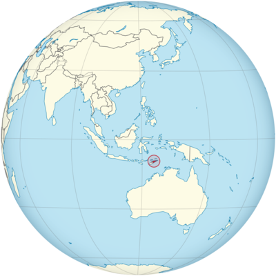
Розташування Східного Тимору на карті світу
На карті ви можете побачити розташування Східного Тимору. Індонезія займає західну частину острова Тимор.
Інформація про місцезнаходження Східного Тимору
Східний Тимор, офіційно відомий як Демократична Республіка Тимор-Лешті, — невелика острівна держава, розташована в Південно-Східній Азії. Вона лежить у Малайському архіпелазі у східній половині острова Тимор і межує з Індонезією на заході та Тиморським морем на півночі. Країна розташована в геополітично важливому регіоні, поблизу Австралії та кількох інших країн Тихого океану.
Широта та довгота
Східний Тимор розташований між 8° та 10° південної широти та 125° та 127° східної довготи. Таке стратегічне розташування ставить країну в тропіки, що сприяє її тропічному клімату, тоді як її розташування поблизу основних морських шляхів впливає на її історичні та сучасні торговельні відносини.
- Широта: Країна простягається між 8° та 10° південної широти, розташована трохи південніше від екватора, що впливає на її погодні умови та тип флори та фауни, що там зустрічаються.
- Довгота: Східний Тимор, що простягається від 125° східної довготи до 127° східної довготи, розташований на східному краю Тиморського моря, а води, що оточують острів, сприяють його біорізноманіттю та торговельним зв’язкам.
Столиця та великі міста
Столицею Східного Тимору є Ділі, яке також є найбільшим містом країни. Ділі служить політичним, економічним та культурним центром країни. Інші важливі міста країни включають Баукау, Лікіса та Маліана, кожне з яких має значення з географічного, історичного чи адміністративного боку.
Ділі
Ділі, розташоване на північному узбережжі острова Тимор, є жвавою столицею та головним міським центром Східного Тимору. Місто розташоване на краю глибокої гавані, оточене горами, і є центром уряду, торгівлі та культури країни.
- Економіка: Ділі є економічним центром Східного Тимору. У місті зосереджені ключові галузі промисловості країни, включаючи нафтогазову, рибальство та туризм. Наявність природних ресурсів, зокрема морських нафтових родовищ, відіграє значну роль в економіці міста.
- Culture and Landmarks: Dili is home to various cultural institutions, including the National Museum of Timor-Leste and Santa Cruz Cemetery, which holds historical significance due to the 1991 massacre. The Cristo Rei statue, which stands at 27 meters tall, is one of the most prominent landmarks in Dili, symbolizing both Catholicism and national pride.
Baucau
Baucau is the second-largest city in East Timor and is located on the eastern coast of the island. Historically, it served as the capital during the Portuguese colonial period, before Dili took over that role.
- Economy: Baucau is important for agriculture, particularly the cultivation of coffee, which is one of East Timor’s main exports. The city also serves as a hub for trade and logistics in the eastern region of the country.
- Culture and Landmarks: Baucau features colonial-era buildings, traditional markets, and stunning coastal scenery. The Baucau Beach is a popular location for both locals and tourists looking to enjoy the natural beauty of the area.
Liquiçá
Liquiçá is a small town located on the northern coast of East Timor, about 30 kilometers west of Dili. The town is historically significant for its involvement in the country’s struggle for independence.
- Economy: The economy of Liquiçá is centered around agriculture, including crops such as coconuts, cassava, and coffee. There is also some involvement in local fishing activities.
- Culture and Landmarks: Liquiçá is an important historical site as it was one of the locations affected by the Indonesian military operations during the struggle for independence. The town is a gateway to the surrounding hills and has several beaches with good diving opportunities.
Maliana
Maliana is a small town located in the western part of the country, near the border with Indonesia. It plays an important role in East Timor’s agricultural sector, and its location close to the border also makes it important for trade.
- Economy: The area around Maliana is known for its fertile agricultural land, growing products like rice, corn, and coffee.
- Culture and Landmarks: Maliana is less developed compared to Dili but provides a more traditional experience of East Timor, with nearby rural areas that showcase the indigenous lifestyle and customs of the Timorese people.
Time Zone
East Timor is located in the East Timor Time (TLT) zone, which is UTC +9:00. This time zone places the country ahead of many countries in Southeast Asia, such as Indonesia, and behind Australia, especially its western part. East Timor does not observe daylight saving time, meaning that the time remains constant throughout the year.
- Standard Time: The standard time in East Timor is UTC +9:00 year-round. This is consistent with neighboring countries such as Japan and South Korea, though the rest of Southeast Asia follows UTC +7:00 or UTC +8:00.
Climate
East Timor has a tropical climate characterized by high temperatures and humidity throughout the year. The country’s climate is influenced by both its equatorial location and its rugged topography.
Coastal Region
The coastal regions, where cities such as Dili and Baucau are located, experience a tropical climate with high temperatures year-round. The temperatures typically range between 25°C and 30°C (77°F to 86°F). The climate here is influenced by the surrounding Timor Sea and monsoonal patterns, with a rainy season from December to April.
Highlands
The central highlands, where towns like Maliana and Liquiçá are located, have a slightly more temperate climate. The altitude of these areas means that temperatures are generally cooler than those in the lowland areas, with average temperatures ranging from 18°C to 25°C (64°F to 77°F).
Rainfall Patterns
East Timor experiences a wet season from November to April and a dry season from May to October. During the wet season, the country receives significant rainfall, particularly in the eastern regions. The wet season can lead to occasional flooding, especially in coastal cities. The dry season is characterized by lower humidity and more comfortable temperatures.
Economic Status
East Timor is one of the world’s youngest nations, having gained independence from Indonesia in 2002. Despite facing challenges related to post-conflict recovery, the country has made strides in developing its economy. The primary sectors that contribute to East Timor’s economy include oil and gas, agriculture, and tourism.
- Oil and Gas: The oil and gas industry is the largest sector of the economy, with revenues derived from the Greater Sunrise gas field in the Timor Sea. The country relies heavily on oil exports, and this sector contributes significantly to government revenues.
- Agriculture: Agriculture remains important to East Timor’s rural population. The country produces coffee, which is one of its main exports, alongside cocoa, rice, and cassava. The country is working on improving agricultural production and infrastructure to increase food security.
- Tourism: East Timor’s tourism industry is still in its early stages, but the country has significant potential due to its unspoiled natural beauty, beaches, and historical sites. The government is actively promoting tourism as a means of diversifying the economy.
- Challenges: East Timor faces significant challenges, including poverty, unemployment, and infrastructure deficits. The country remains heavily dependent on foreign aid and oil revenues, and there is a need for economic diversification. Additionally, the country is working to address issues related to governance, education, and healthcare.
Tourist Attractions
East Timor offers a variety of unique tourist attractions, including cultural landmarks, pristine beaches, and ecological sites. Its relatively undeveloped tourism sector makes it an attractive destination for travelers seeking to experience a more authentic and off-the-beaten-path adventure.
The Beaches of East Timor
East Timor is renowned for its beautiful, unspoiled beaches, which are ideal for activities such as diving, snorkeling, and swimming. Some of the best-known beaches include Atauro Island, which is famous for its coral reefs, and Jaco Island, a pristine, uninhabited island that is a popular destination for eco-tourists.
The Islands
Atauro Island, located just off the coast of Dili, is a popular destination for travelers seeking natural beauty, including vibrant coral reefs and secluded beaches. It is a perfect location for diving and exploring marine biodiversity.
Jaco Island is another well-known spot in East Timor, with untouched beaches and crystal-clear waters. This island is home to rich wildlife and is part of the Nino Konis Santana National Park.
Historical and Cultural Sites
Історію та боротьбу Східного Тимору за незалежність увічнюють у кількох місцях по всій країні. Кладовище Санта-Крус у Ділі вшановує місце різанини в Санта-Крус 1991 року, де індонезійські солдати вбили десятки тиморців. Національний музей Східного Тимору пропонує відвідувачам глибокий погляд на історію та культуру країни.
Природа та дика природа
Природне середовище Східного Тимору є головною принадою для екотуристів. Національний парк Ніно Коніс Сантана – це заповідна територія у східній частині країни, відома своїм біорізноманіттям, включаючи ендемічні види птахів, рослин та морських мешканців. Парк також пропонує чудові можливості для піших прогулянок та трекінгу.
Візові вимоги для громадян США
Громадянам США, які подорожують до Східного Тимору з метою туризму або бізнесу, віза не потрібна для перебування до 90 днів. Однак вони повинні мати дійсний паспорт, термін дії якого становить щонайменше шість місяців з дати в’їзду.
Для тривалішого перебування або з метою, такою як працевлаштування, навчання чи проживання, громадяни США повинні подати заявку на отримання візи через найближче посольство або консульство Східного Тимору.
Відстань до Нью-Йорка та Лос-Анджелеса
- Відстань до Нью-Йорка: Відстань від Ділі, столиці Східного Тимору, до Нью-Йорка становить приблизно 10 000 миль (16 000 кілометрів). Перельоти зазвичай тривають від 20 до 24 годин з пересадками у великих транзитних вузлах, таких як Сінгапур або Джакарта.
- Відстань до Лос-Анджелеса: відстань від Ділі до Лос-Анджелеса становить приблизно 9 500 миль (15 300 кілометрів). Типовий переліт триває від 18 до 22 годин із пересадками в Сінгапурі, Джакарті або інших транзитних пунктах Азії.
Факти про Східний Тимор
| Розмір | 14 918 км² |
| Мешканці | 1,38 мільйона |
| Мови | Тетум та португальська |
| Капітал | Ділі |
| Найдовша річка | Лоїс (80 км) |
| Найвища гора | Татамайлау (2963 м) |
| Валюта | долар США |


