Where is Syria Located?
Where is Syria located on the map? Syria is an independent nation located in Western Asia. Check out the following images to see location of Syria on maps.
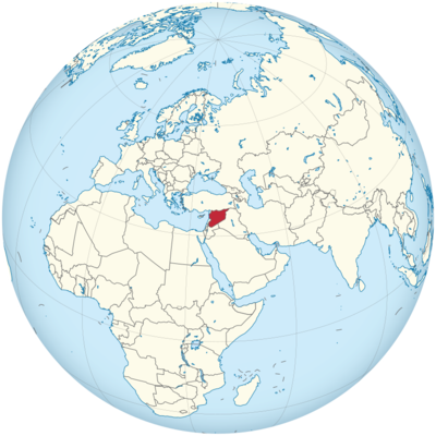
Syria Location in World Map
Syria is in the Middle East.
Location Information of Syria
Syria is a country located in the Middle East, on the eastern shore of the Mediterranean Sea. It is bordered by Turkey to the north, Iraq to the east, Jordan to the south, Lebanon and Israel to the southwest, and the Mediterranean Sea to the west. Syria’s location has made it a historical crossroads for trade, culture, and civilizations for thousands of years. The country is strategically important in the Levant region, a part of the Arab world.
Latitude and Longitude
Syria lies between 32° and 37° North latitude and 35° and 42° East longitude. This places it in the Middle East, with a diverse topography ranging from coastal plains to mountain ranges and desert plateaus.
Capital City and Major Cities
Capital City: Damascus
The capital and largest city of Syria is Damascus, one of the oldest continuously inhabited cities in the world. It is located in the southwestern part of the country, near the Barada River and at the foot of the Anti-Lebanon Mountains. Damascus has long been the center of Syrian political, cultural, and religious life, making it an important historical and economic hub. The city is home to a population of around 2 million people, with a metropolitan area exceeding 5 million.
Key features of Damascus include:
- The Umayyad Mosque: One of the oldest and largest mosques in the world, this mosque is an architectural masterpiece and a UNESCO World Heritage site.
- Old City of Damascus: A UNESCO World Heritage site, the Old City is full of ancient markets (souks), traditional houses, and historic buildings, reflecting the city’s rich history.
- The National Museum of Damascus: This museum showcases Syria’s rich history, including artifacts from the ancient city of Palmyra and Roman ruins.
Major Cities
- Aleppo: Located in the northern part of the country, Aleppo is Syria’s second-largest city. Historically, it has been a major center for trade, manufacturing, and cultural exchange. Aleppo’s population was over 2 million before the Syrian Civil War, though it has been significantly reduced due to the ongoing conflict. The city is renowned for its Old City, a UNESCO World Heritage site, and its famous Citadel of Aleppo. Coordinates: 36.2023° N, 37.1343° E.
- Homs: Situated in the central part of Syria, Homs is a major industrial city, often referred to as the “capital of the Syrian Revolution.” The city has seen significant destruction during the Syrian Civil War. Prior to the war, it had a population of around 1 million. The city is historically significant for its Roman ruins and medieval architecture. Coordinates: 34.7325° N, 36.7181° E.
- Latakia: Located on the Mediterranean coast, Latakia is Syria’s primary port city. It is important for the country’s shipping and trade industries, and it has also been a hub for tourism due to its proximity to the coast and natural beauty. The city has a population of around 400,000. Coordinates: 35.5370° N, 35.7823° E.
- Tartus: Another port city on the Mediterranean coast, Tartus is known for its naval base and commercial port. It has a population of around 100,000 people and is a historically significant city with ancient Phoenician ruins. Coordinates: 34.8953° N, 35.8806° E.
- Raqqa: Situated in the north-central part of Syria, Raqqa was once an important city for agriculture, particularly cotton. It gained international attention during the Syrian Civil War, especially when it became the self-declared capital of the Islamic State (ISIS) in 2014. The population has fluctuated due to the war and displacement. Coordinates: 35.9453° N, 39.0193° E.
Time Zone
Syria operates on Eastern European Time (EET), which is UTC +2:00 during the winter months. During Daylight Saving Time (DST), Syria shifts to UTC +3:00, typically from March to October.
- Time difference with New York City: Syria is 7 hours ahead of New York City during Standard Time (EST) and 6 hours ahead during Daylight Saving Time (EDT).
- Time difference with Los Angeles: Syria is 10 hours ahead of Los Angeles during Standard Time (PST) and 9 hours ahead during Daylight Saving Time (PDT).
Climate
Syria experiences a variety of climates due to its diverse geography, ranging from Mediterranean coastal weather to continental desert conditions in the interior. Generally, Syria has hot, dry summers and cold, wet winters, with variations in temperature and precipitation depending on the region.
- Coastal Areas: Cities like Latakia and Tartus have a Mediterranean climate, with mild, wet winters and hot, dry summers. Average temperatures in winter range from 10°C to 15°C (50°F to 59°F), while summer temperatures can reach up to 30°C (86°F).
- Inland and Desert Areas: Cities like Damascus, Aleppo, and Raqqa experience a continental climate with hot summers and cold winters. Summers can see temperatures exceeding 35°C (95°F), while winter temperatures can drop to 0°C (32°F) or lower, particularly in the higher elevations.
- Mountains and High Altitudes: The Anti-Lebanon and Alawite Mountains see more significant seasonal temperature changes. Winters can bring snow and freezing temperatures, while summers remain pleasant, with temperatures averaging between 20°C to 25°C (68°F to 77°F).
Economic Status
Syria’s economy has been severely affected by the ongoing Syrian Civil War that started in 2011. Prior to the war, Syria had a diverse economy based on agriculture, industry, oil, and services. However, the war has led to widespread destruction of infrastructure, significant loss of life, and a large displacement of people. Sanctions imposed by various countries, especially Western nations, have also crippled the economy.
Key Sectors of the Economy:
- Agriculture: Before the war, Syria was a major producer of cotton, wheat, barley, fruit, and vegetables. Agriculture employed a large portion of the population. However, the war and drought have severely affected production.
- Oil and Gas: Syria had significant oil reserves before the war, and oil was one of the country’s primary exports. However, the conflict has led to the destruction of oil infrastructure, and Syria’s ability to produce and export oil has significantly decreased. The government has turned to Iran and Russia for energy support.
- Manufacturing: Syria was known for its textile, food processing, and cement industries before the war. Many of these sectors have been damaged or destroyed, though some small-scale production continues.
- Remittances: Due to the high level of migration during the conflict, remittances from Syrians living abroad, particularly in countries like Lebanon, Jordan, and Gulf States, have become a crucial source of income.
- Tourism: Syria was once a popular destination for tourists, attracting visitors with its ancient cities like Palmyra, Bosra, and Damascus, as well as its historical and cultural landmarks. However, due to the war, tourism has been almost entirely wiped out, and many of the country’s UNESCO World Heritage sites have been damaged or destroyed.
Tourist Attractions
Syria is rich in historical and cultural landmarks, many of which are ancient and UNESCO World Heritage-listed. However, the ongoing conflict has resulted in the destruction of some of these sites. Despite this, there are still many places that reflect the deep cultural and historical significance of the country.
1. The Ancient City of Palmyra
Palmyra was once a thriving trade center and a vital city of the ancient world. It is famous for its Roman ruins, including the Temple of Bel, the Tetrapylon, and the Colonnade. The city has suffered significant damage during the war, particularly at the hands of ISIS, but it remains a symbol of Syria’s rich heritage.
2. Crac des Chevaliers
One of the best-preserved medieval castles in the world, Crac des Chevaliers is located in the western part of Syria. It was built during the Crusader period and has strategic significance due to its location. The castle offers stunning views of the surrounding countryside.
3. The Umayyad Mosque (Damascus)
As one of the oldest and most significant mosques in the Muslim world, the Umayyad Mosque is a stunning example of Islamic architecture. Located in Damascus, the mosque is a major religious site for Sunnis and features impressive mosaics and historic tombs.
4. Bosra
Bosra is an ancient city and UNESCO World Heritage site that was once the capital of the Roman province of Arabia. The Roman Theater in Bosra is one of the best-preserved in the world, and the site also features well-preserved Roman baths and a Byzantine church.
Visa Requirements for U.S. Citizens
U.S. citizens are not advised to travel to Syria due to the ongoing civil war, instability, and safety concerns. The U.S. Department of State issues a Level 4 travel advisory, urging Americans to avoid travel to Syria.
For those who do seek to visit Syria, a visa is required. The visa can typically be obtained through the Syrian Embassy, though it is difficult to acquire due to the political situation. The requirements for a Syrian visa usually include:
- A valid U.S. passport.
- A completed visa application.
- A passport-sized photo.
- Proof of onward travel.
- Visa fee (varies based on type).
Distance to New York City and Los Angeles
- Distance from Damascus to New York City: Approximately 10,000 km (6,213 miles), with a flight time of around 12 to 14 hours.
- Distance from Damascus to Los Angeles: Approximately 11,000 km (6,835 miles), with a flight time of about 13 to 15 hours, depending on layovers.
Syria Facts
| Size | 185,180 km² |
| Residents | 17.1 million – of which more than 5 million fled abroad |
| Language | Arabic |
| Capital | Damascus |
| Longest river | Euphrates (total length 2,736 km) |
| Highest mountain | Hermon (2,814 m) |
| Currency | Syrian pound |


