Where is Suriname Located?
Where is Suriname located on the map? Suriname is an independent nation located in South America. Check out the following images to see location of Suriname on maps.
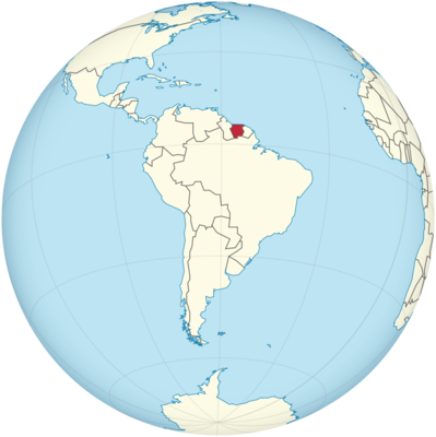
Suriname Location in World Map
Location of Suriname in South America on the map.
Location Information of Suriname
Suriname is a small country located on the northern coast of South America, bordered by French Guiana to the east, Brazil to the south, and Guyana to the west. To the north, Suriname has a coastline along the Atlantic Ocean. Despite its small size, Suriname is rich in biodiversity, natural resources, and has a fascinating mix of ethnic and cultural backgrounds.
Latitude and Longitude
Suriname lies between 3° and 6° North latitude and 54° and 58° West longitude. The country spans an area of 163,820 square kilometers (63,251 square miles), making it the smallest country in South America by land area. Its location places it in the tropics, giving it a hot and humid climate, with dense rainforests and a variety of ecosystems.
Capital City and Major Cities
Capital City: Paramaribo
The capital and largest city of Suriname is Paramaribo, located on the Suriname River about 15 kilometers inland from the Atlantic coast. The city has a population of approximately 250,000 people and serves as the political, economic, and cultural center of the country. Paramaribo is known for its Dutch colonial architecture, which has earned it a place as a UNESCO World Heritage Site.
Some of the prominent landmarks in Paramaribo include:
- Fort Zeelandia: A historical Dutch fort dating back to the 17th century, now housing a museum about Suriname’s colonial history.
- Saint Peter and Paul Cathedral: A large wooden cathedral, known for its striking architecture and one of the tallest wooden structures in the Western Hemisphere.
- Palmentuin Park: A public park with a variety of palm trees and a popular spot for locals and tourists alike.
Major Cities
- Nickerie: Located in the northwestern part of Suriname, Nickerie is the country’s second-largest city, with a population of about 40,000. The city is an important hub for agriculture, particularly rice cultivation, and is near the Corantijn River, which forms part of the border with Guyana. Coordinates: 5.9401° N, 56.9736° W.
- Albina: A town on the eastern border with French Guiana, Albina has around 10,000 residents and is a key commercial center due to its position along the Maroni River. It is also a major crossing point between Suriname and French Guiana. Coordinates: 5.7149° N, 54.0417° W.
- Moengo: Situated in the northeastern part of Suriname, Moengo is a town known for its mining industry, particularly bauxite extraction. The town has a population of approximately 10,000 people and is one of the more industrialized areas of the country. Coordinates: 5.9745° N, 54.2834° W.
- Stoelmanseiland: Located on an island in the Marowijne River in the eastern part of the country, Stoelmanseiland is a small town with a population of approximately 2,000 people. It serves as a transport hub to nearby areas in the northeastern rainforest. Coordinates: 5.8086° N, 54.1192° W.
Time Zone
Suriname operates on Suriname Time (SRT), which is UTC -3:00. The country does not observe Daylight Saving Time, so the time remains constant throughout the year.
- Time difference with New York City: Suriname is 2 hours ahead of New York City during Standard Time (New York City operates on UTC -5).
- Time difference with Los Angeles: Suriname is 4 hours ahead of Los Angeles during Standard Time (Los Angeles operates on UTC -8).
Climate
Suriname has a tropical climate, characterized by high temperatures, high humidity, and significant rainfall. The country experiences two distinct rainy seasons: a long rainy season from April to August, and a short rainy season from November to February. The average temperature throughout the year ranges from 25°C to 32°C (77°F to 90°F). Humidity levels are generally high, and the country’s climate is conducive to lush vegetation, including dense rainforests, swamps, and wetlands.
Climate Zones:
- Coastal region: The coastal region, where Paramaribo and Nickerie are located, tends to be more humid and experiences rainfall throughout the year, especially during the rainy seasons.
- Interior region: The interior of the country, particularly the rainforests and mountainous areas, is subject to more rainfall and has a slightly cooler climate, particularly at higher altitudes.
Economic Status
Suriname has a small, open economy, heavily reliant on natural resources and exports. The country’s economy is largely driven by the mining, agriculture, and oil sectors. However, the country faces economic challenges, including high levels of public debt and inflation, and has struggled with income inequality and poverty. In recent years, Suriname’s government has worked to stabilize the economy and encourage foreign investment.
Key Sectors of the Economy:
- Mining: Suriname’s mining industry is crucial to its economy. The country is rich in bauxite, which is the primary source of aluminum, and is one of the world’s top producers. Additionally, gold mining is a significant industry, with Suriname being a notable exporter of gold.
- Oil: Suriname has significant offshore oil reserves in the Atlantic Ocean, and oil exploration has been a major focus for the country in recent years. The oil sector has contributed to economic growth, though it remains vulnerable to global oil price fluctuations.
- Agriculture: Agriculture remains an important sector in Suriname, with crops like rice, bananas, cocoa, and palm oil being major exports. The country also produces timber, shrimp, and sugar.
- Services: The services sector in Suriname has been growing, particularly in tourism and finance. The capital city, Paramaribo, is the center for banking and trade activities. However, services remain a smaller contributor compared to mining and agriculture.
Tourist Attractions
Suriname is rich in natural beauty, offering visitors a chance to explore dense rainforests, vast rivers, and diverse wildlife. The country is also home to a rich cultural heritage, with indigenous communities, descendants of African slaves, and Dutch colonial influences all contributing to its unique identity.
1. Central Suriname Nature Reserve
A UNESCO World Heritage Site, the Central Suriname Nature Reserve is one of the largest protected tropical rainforests in the world. Spanning over 1.6 million hectares, this reserve is home to a diverse range of wildlife, including jaguars, tapirs, and numerous species of birds and insects. The reserve is a haven for eco-tourists and nature lovers, offering opportunities for trekking, camping, and wildlife watching.
2. Brownsberg Nature Park
Located in the Brownsberg Mountains, this park is a popular destination for hiking and enjoying panoramic views of the surrounding rainforest. The park also contains several waterfalls, including Leopold Falls, and is known for its birdwatching opportunities.
3. Galibi Nature Reserve
Located along the coast near the French Guiana border, Galibi Nature Reserve is known for its turtle conservation efforts. This reserve is one of the few places in Suriname where green sea turtles come ashore to lay their eggs, making it a popular eco-tourism site.
4. Fort Zeelandia
This 17th-century fort in Paramaribo is one of the best-preserved historical landmarks in Suriname. Originally built by the Dutch, the fort now houses the Suriname Museum, which tells the story of the country’s colonial past and its path to independence.
5. The Peperpot Nature Park
The Peperpot Nature Park, located near Paramaribo, is a perfect spot for hiking and exploring Suriname’s flora and fauna. The park was once a coffee plantation, and visitors can see remnants of the old plantation buildings while enjoying the park’s natural beauty.
Visa Requirements for U.S. Citizens
U.S. citizens traveling to Suriname for tourism do require a visa. The tourist visa must be obtained prior to arrival, and applicants can submit their visa applications to the Embassy of Suriname in Washington, D.C. or through the Suriname Consulate in New York City. The visa is generally valid for a stay of up to 90 days, and travelers are required to provide necessary documents such as:
- A valid passport (with at least 6 months of validity)
- A completed visa application form
- Proof of onward travel (such as a return ticket)
- Proof of sufficient funds for the duration of the stay
- Visa fee payment
Additionally, some travelers may be able to obtain a visa upon arrival if they have a valid Schengen visa or a valid U.S. visa.
Distance to New York City and Los Angeles
- Distance from Paramaribo to New York City: The approximate distance between Paramaribo and New York City is 4,000 km (2,485 miles). The flight typically takes around 6 to 7 hours.
- Distance from Paramaribo to Los Angeles: The approximate distance to Los Angeles is 5,300 km (3,300 miles), with flight times around 8 to 9 hours, depending on the specific flight route and layovers.
Suriname Facts
| Size | 163,265 km² |
| Residents | 576,000 |
| Language | Dutch (official language) |
| Capital | Paramaribo |
| Longest river | Suriname (480 km) |
| Highest mountain | Julianatop (1,280 m) |
| Currency | Suriname dollar |


