Where is Peru Located?
Where is Peru located on the map? Peru is an independent nation located in South America. Check out the following images to see location of Peru on maps.
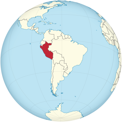
Peru Location in World Map
Location of Peru in South America on the map.
Location Information of Peru
Latitude and Longitude
Peru is a country located on the western coast of South America, bordered by Ecuador, Colombia, Brazil, Bolivia, and Chile. The geographical coordinates of Peru are approximately between Latitude 0° 00′ S and 18° 21′ S and Longitude 68° 41′ W and 81° 20′ W. The country spans a diverse range of landscapes from the Pacific coastline to the Andean mountain range and the Amazon rainforest, making it a geographically and ecologically rich region.
Capital City and Major Cities
Capital City: Lima
Lima is the capital and largest city of Peru, located on the central coast of the country, along the Pacific Ocean. It is one of the largest cities in Latin America, with a population of around 10 million people in its metropolitan area. Lima serves as the political, economic, and cultural hub of Peru, housing the central government, financial districts, and historical landmarks. Founded by Spanish conquistadors in 1535, the city is known for its colonial architecture, rich history, and vibrant modern culture. The historical center of Lima, recognized as a UNESCO World Heritage Site, includes landmarks such as Plaza Mayor and The Cathedral of Lima.
Major Cities
- Arequipa
Arequipa is the second-largest city in Peru and is often referred to as the “White City” due to its beautiful colonial architecture made from white volcanic stone. Located in the southern part of the country, Arequipa is known for its stunning backdrop of the Misti Volcano and its proximity to the Colca Canyon, one of the deepest canyons in the world. The city is also a center for education and industry in Peru. - Cusco
Cusco, located in the Andes Mountains, is one of the most historically significant cities in Peru. Once the capital of the Inca Empire, Cusco is now the gateway to the Machu Picchu archaeological site and is a major center for tourism. The city has a vibrant mixture of Inca and Spanish colonial architecture, with famous landmarks such as the Qorikancha Temple and the Sacsayhuamán Fortress. - Trujillo
Trujillo is located on the northern coast of Peru and is the third-largest city in the country. It is an important commercial and industrial center, known for its proximity to the ancient ruins of the Moche and Chimú cultures, such as Chan Chan, the largest pre-Columbian city in South America. Trujillo is also famous for its beautiful beaches and its role in the development of Peruvian culture. - Piura
Piura, located in the northwestern region of Peru, is the capital of the Piura Department. It is known for its dry climate and vibrant culture, which blends indigenous, African, and Spanish influences. Piura is also the gateway to the beaches of the Máncora area, which is a popular destination for both domestic and international tourists. - Chiclayo
Chiclayo is located on the northern coast of Peru and is the capital of the Lambayeque region. It is known for its archaeological sites such as Sipán, where the tomb of the ancient Moche ruler was discovered. Chiclayo is also an important commercial city and is known for its role in regional agriculture.
Time Zone
Peru is located in the Peru Time Zone (PET), which is UTC -5:00 hours. Peru does not observe Daylight Saving Time, meaning the time remains constant throughout the year. This time zone places Peru in alignment with several other countries in South America, including Colombia and Ecuador.
Climate
The climate of Peru is highly diverse, influenced by the country’s varied geography, which includes coastal plains, mountain ranges, and tropical rainforests. Peru has three primary climate zones: the coastal, highland, and Amazonian regions.
Coastal Region
The coastal region of Peru, including Lima, is characterized by a desert climate with mild temperatures and little rainfall. The coastal cities typically experience temperatures between 14°C (57°F) and 28°C (82°F) year-round, with a cool, humid season from June to September, when the famous garúa mist (a form of fog) is common. The temperature is relatively stable, but the lack of rain and dry conditions make the coastal areas arid, particularly in the northern and southern parts of the coast.
Highland Region
The highland region, which includes cities like Cusco and Arequipa, has a mountain climate. The climate varies considerably depending on elevation. At lower altitudes, temperatures range from 16°C (61°F) to 25°C (77°F), while higher altitudes experience colder temperatures, often dropping below freezing in the winter. This region also experiences a rainy season from November to March, particularly in the Andes, and a dry season from April to October.
Amazonian Region
The Amazon Basin in the east of Peru, which includes cities like Iquitos, experiences a tropical climate with high humidity and significant rainfall. Average temperatures range between 24°C (75°F) and 30°C (86°F) year-round. The region is known for its rainy season from November to April and its dry season from May to October. The Amazon rainforest offers rich biodiversity and is a key ecological area for Peru.
Economic Status
Peru has one of the most dynamic economies in South America, driven by a combination of resource extraction, agriculture, services, and tourism. Peru’s economic growth in the 21st century has been significant, largely due to exports of mineral resources, particularly copper, gold, and silver, and its agricultural products.
Key Economic Sectors
- Mining
Mining is one of the most important sectors of Peru’s economy, with the country being one of the top producers of minerals like copper, gold, silver, and zinc. Peru is the second-largest producer of copper in the world, and mining exports account for a large portion of the country’s GDP. The mining sector has attracted foreign investment and has contributed significantly to the nation’s economic growth. - Agriculture
Agriculture is another key component of Peru’s economy. The country is a major producer of coffee, asparagus, grapes, and quinoa. Peru has gained prominence in the global agricultural market due to its unique biodiversity and its diverse range of crops, which are exported worldwide. Agriculture also plays a crucial role in rural areas and contributes to poverty reduction in some regions. - Tourism
Tourism is an essential sector for Peru’s economy, especially with global recognition of attractions like Machu Picchu, the Nazca Lines, and Lake Titicaca. The tourism industry in Peru is a significant driver of job creation and foreign currency earnings. In recent years, eco-tourism and cultural tourism have gained popularity, with visitors drawn to the country’s natural wonders and rich cultural heritage. - Fishing
Peru’s fishing industry is one of the largest in the world, primarily based on the harvest of anchovies, which are used in fishmeal production for animal feed and aquaculture. Peru is also a major exporter of seafood, particularly fish, squid, and shellfish. - Manufacturing
Peru’s manufacturing sector is diversified, with significant production of food processing, textiles, clothing, and chemicals. The country’s free trade agreements with the United States and the European Union have spurred growth in exports of manufactured goods.
Despite the impressive growth in several sectors, challenges such as poverty, income inequality, and political instability persist in Peru, which hinders broader social and economic development.
Tourist Attractions
Peru is renowned for its rich cultural heritage and diverse ecosystems, offering a wide range of attractions for tourists. Some of the top destinations include:
- Machu Picchu
Machu Picchu is one of the most famous archaeological sites in the world and a UNESCO World Heritage Site. Located in the Andes, this ancient Inca city attracts millions of visitors each year. The site is known for its stunning location atop a mountain and its remarkable preservation, with structures like the Temple of the Sun and the Intihuatana stone. - Cusco and the Sacred Valley
Cusco is the former capital of the Inca Empire and remains one of Peru’s most important cultural cities. The Sacred Valley, near Cusco, is home to numerous Incan archaeological sites, including Ollantaytambo and Pisac. The valley also offers a rich mix of indigenous cultures, scenic landscapes, and outdoor adventure activities. - Nazca Lines
The Nazca Lines are a series of enormous geoglyphs etched into the desert floor in southern Peru. The lines, which can only be fully appreciated from the air, are a mystery to scientists and attract tourists interested in ancient cultures and unexplained phenomena. - Lake Titicaca
Lake Titicaca, the highest navigable lake in the world, is located on the border between Peru and Bolivia. The lake is home to various indigenous communities and offers opportunities for boat tours, visits to the Uros Islands (floating islands made of reeds), and exploration of Taquile Island. - Colca Canyon
Colca Canyon is one of the deepest canyons in the world, and it is a popular destination for hiking and exploring the natural beauty of Peru. Visitors often see the Andean condor, one of the world’s largest flying birds, soaring over the canyon’s cliffs. - Amazon Rainforest
The Amazon Basin in Peru is home to an incredibly diverse range of wildlife and ecosystems. Visitors can explore the Tambopata National Reserve or Manú National Park and take guided tours into the rainforest to see exotic animals and plants, including jaguars, monkeys, and macaws. - Paracas National Reserve and Ballestas Islands
The Paracas National Reserve, located on the coast of southern Peru, is home to diverse wildlife and stunning coastal landscapes. The nearby Ballestas Islands are often referred to as the “Galapagos of Peru” because of their rich biodiversity, including sea lions, penguins, and hundreds of bird species.
Visa Requirements for U.S. Citizens
U.S. citizens can travel to Peru for tourism without requiring a visa for stays of up to 183 days. However, travelers must have a valid U.S. passport, which should be valid for at least six months beyond the intended departure date. It is also recommended to have a return or onward ticket and proof of sufficient funds for the duration of the stay.
Visitors from the United States may need to provide additional documentation, such as a yellow fever vaccination certificate, depending on their travel history, especially if they have visited other South American countries with reported yellow fever outbreaks.
Distance to New York City and Los Angeles
- Distance from New York City to Lima
The distance between New York City and Lima, Peru, is approximately 3,400 miles (5,472 kilometers). Direct flights from NYC to Lima typically take around 8 hours. - Distance from Los Angeles to Lima
The distance between Los Angeles and Lima is approximately 4,100 miles (6,600 kilometers). Flights from Los Angeles to Lima typically take 8 to 9 hours, depending on layovers.
Peru Facts
| Size | 1,285,216 km² |
| Residents | 31.98 million |
| Language | Spanish (official language) |
| Capital | Lima |
| Longest river | Río Ucayali (1771 km) |
| Highest mountain | Nevado Huascarán (6,768 m) |
| Currency | New sol |


