Where is Papua New Guinea Located?
Where is Papua New Guinea located on the map? Papua New Guinea is an independent nation located in Melanesia. Check out the following images to see location of Papua New Guinea on maps.
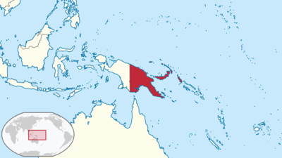
Papua New Guinea Location in World Map
Location Information of Papua New Guinea
Latitude and Longitude
Papua New Guinea is located in Oceania, in the southwestern Pacific Ocean, and is the second-largest island country in the world. It shares the island of New Guinea with Indonesia to the west. The country’s approximate geographic coordinates are 6.3149° S latitude and 143.9555° E longitude. Papua New Guinea is located to the north of Australia, and it consists of the mainland of New Guinea, numerous smaller islands, and the Bismarck Archipelago, among others. Papua New Guinea’s geographic location places it within the tropical zone, which contributes to its rich biodiversity and ecosystems, from tropical rainforests to coral reefs.
The country’s land area is approximately 462,840 square kilometers (178,704 square miles), with vast stretches of mountains, rivers, and tropical forests that make it one of the most ecologically diverse countries in the world.
Capital City and Major Cities
Capital City: Port Moresby
The capital city of Papua New Guinea is Port Moresby, located on the southern coast of the Papua New Guinea mainland, along the Gulf of Papua. Port Moresby is the largest city in the country and the political, economic, and cultural center, with a population of over 400,000 people. The city serves as the hub for government administration, international diplomacy, and commerce. Port Moresby is known for its port facilities, beautiful beaches, and surrounding tropical landscapes. It is home to landmarks like the National Museum and Art Gallery, Bomana War Cemetery, and Port Moresby Nature Park.
Major Cities
- Lae: Located on the northern coast of Papua New Guinea, Lae is the second-largest city in the country, with a population of around 100,000. It is an important industrial and commercial hub, serving as the major port for trade on the Huon Gulf. Lae is also a center for agriculture, particularly the production of cocoa, coffee, and palm oil. Major attractions include the Lae Botanical Gardens and Nadzab Airport, which is a key transport hub.
- Madang: Madang, located on the north coast of Papua New Guinea, is known for its beautiful coastline and coral reefs. The city has a population of around 30,000 and is famous for its scenic views, including coves, beaches, and the nearby Raikos Peninsula. Madang is a key center for tourism, with attractions such as diving spots around the Madang Lagoon and visits to Karkar Island.
- Mount Hagen: Situated in the highlands of Papua New Guinea, Mount Hagen is the third-largest city in the country, with a population of around 45,000 people. The city serves as a key administrative and commercial center for the Western Highlands Province. Mount Hagen is surrounded by beautiful mountain scenery and is a hub for agriculture, particularly coffee. The Mount Hagen Cultural Show is one of the key cultural events in the region, showcasing traditional Papuan dances and art.
- Kokopo: Located on the island of New Britain in the East New Britain Province, Kokopo has a population of about 20,000 people. The city is known for its proximity to Rabaul, a former capital of Papua New Guinea before it was destroyed by a volcanic eruption. Kokopo is an important tourism and trade center, with attractions such as the Rabaul Volcano Observatory, Tavurvur Volcano, and historical landmarks from World War II.
- Goroka: Located in the Eastern Highlands region of Papua New Guinea, Goroka has a population of around 25,000 people. It is known for its cooler climate and its importance as an agricultural center for coffee and vegetable production. Goroka is famous for the Goroka Show, one of the most significant cultural festivals in the country, celebrating the diverse traditional customs and arts of the indigenous peoples.
Time Zone
Papua New Guinea operates on Pacific Standard Time (PST), which is UTC +10:00. This time zone is shared with other countries in the Pacific region, such as Australia’s Eastern Standard Time (EST). Papua New Guinea does not observe Daylight Saving Time, meaning the time remains the same throughout the year.
Climate
Papua New Guinea has a tropical climate, with distinct wet and dry seasons. The country’s climate is strongly influenced by its location near the equator, giving it warm and humid weather year-round. The climate can vary significantly between regions due to the diverse geography of the country, with coastal areas experiencing a more consistent climate and the highlands having cooler temperatures.
1. Coastal Climate
The coastal regions, including cities like Port Moresby and Lae, experience a typical tropical climate with warm temperatures ranging from 25°C to 32°C (77°F to 90°F). These areas have two main seasons: a wet season from December to March and a dry season from April to November. During the wet season, rainfall is frequent, and humidity is high, while the dry season sees reduced rainfall and more moderate temperatures.
2. Highland Climate
The highland areas of Papua New Guinea, such as Mount Hagen and Goroka, experience a temperate climate with cooler temperatures. Average temperatures range from 15°C to 25°C (59°F to 77°F), and the region is characterized by cloudy skies and frequent rainfall, especially during the wet season. The cooler temperatures in the highlands make it an attractive region for agriculture and for those looking to escape the intense heat of the coastal regions.
3. Rainfall and Storms
Papua New Guinea experiences heavy rainfall, especially in the coastal and lowland regions. The wet season typically lasts from December to March, while the dry season runs from April to November. The country is also vulnerable to tropical storms and cyclones, which are most frequent during the wet season. The mountains and highlands also experience significant rainfall, but the rain tends to be more intermittent.
Economic Status
Papua New Guinea has a mixed economy, heavily dependent on natural resources such as mining, forestry, and agriculture. The country’s economy is one of the largest in the Pacific Islands, and it has experienced growth in sectors like tourism, construction, and fisheries. Despite this, the country faces significant challenges in areas such as infrastructure, poverty, unemployment, and education.
1. Natural Resources
Papua New Guinea has rich mineral resources, including gold, copper, oil, and natural gas. The mining industry is a key contributor to the country’s economy, with large projects such as the Porgera Gold Mine, Lihir Gold Mine, and Ramu Nickel Project contributing significantly to exports and revenue. The oil and gas sectors also play an important role, with companies operating in the Papuan Basin and offshore fields.
2. Agriculture and Fisheries
Agriculture is a significant part of the economy, with the majority of the population engaged in subsistence farming. The country is a major exporter of coffee, cocoa, oil palm, and copra (dried coconut meat). The fisheries sector is another important contributor, with the country’s rich marine resources making it one of the world’s top producers of tuna and other seafood.
3. Tourism
Tourism is an increasingly important industry for Papua New Guinea, with travelers drawn to the country’s rich cultural diversity, natural beauty, and opportunities for eco-tourism. Visitors are attracted to the country’s rainforests, coral reefs, and cultural festivals, such as the Hiri Moale Festival and Goroka Show. The country is also known for its diving and snorkeling opportunities in places like Kimbe Bay and the Tufi Resort.
4. Challenges
Despite its rich resources, Papua New Guinea faces challenges such as income inequality, poor infrastructure, and a dependence on the mining and oil sectors, which leaves the country vulnerable to global commodity price fluctuations. The government has made efforts to diversify the economy, but challenges remain in improving education, healthcare, and access to services in rural areas.
Tourist Attractions
- Port Moresby Nature Park Located in the capital city, Port Moresby Nature Park is a wildlife conservation park that offers a chance to see native bird species, marsupials, and reptiles. The park is part of the country’s efforts to conserve its unique biodiversity, and visitors can enjoy walking trails, birdwatching, and education about the country’s ecosystems.
- Tufi Resort and Diving The Tufi Resort, located on the Owen Stanley Range, offers a remote tropical escape with diving, snorkeling, and cultural experiences. The area is known for its beautiful coral reefs and diving opportunities, including visits to World War II wrecks in the surrounding waters.
- Kokoda Track The Kokoda Track is one of the most famous trekking routes in Papua New Guinea, known for its historical significance during World War II. The track takes visitors through dense jungle, rugged mountains, and historical sites, making it a must-do adventure for trekking enthusiasts.
- Rabaul Rabaul, located on New Britain Island, is an area famous for its volcanic activity and historical importance during World War II. Visitors can explore volcanoes, hot springs, and bunkers from the war. The Rabaul Volcano Observatory offers views of Tavurvur Volcano and other surrounding craters.
- Bismark Archipelago The Bismark Archipelago consists of several islands, including New Ireland, New Britain, and Manus Island, all known for their natural beauty and cultural diversity. The islands offer excellent snorkeling, diving, and cultural experiences with traditional Melanesian villages.
Visa Requirements for U.S. Citizens
U.S. citizens visiting Papua New Guinea for tourism purposes can enter the country without a visa for stays of up to 60 days. A valid U.S. passport is required, and it must be valid for at least six months beyond the planned departure date. Travelers may be required to show proof of onward travel and sufficient funds for their stay. For longer stays or business purposes, a visa must be obtained through the Papua New Guinea Embassy.
Distance to New York City and Los Angeles
Distance to New York City
The distance from New York City to Port Moresby is approximately 9,700 miles (15,600 kilometers). Flights typically take about 20 to 22 hours, depending on layovers and the flight route.
Distance to Los Angeles
The distance from Los Angeles to Port Moresby is around 7,500 miles (12,000 kilometers). Flights from Los Angeles generally take around 17 to 20 hours, with at least one stopover in cities like Sydney, Brisbane, or Manila.
Papua New Guinea Facts
| Size | 462,840 km² |
| Residents | 8.6 million |
| Languages | Tok Pisin, Hiri Motu, English |
| Capital | Port Moresby |
| Longest river | Sepik (1,200 km) |
| Highest mountain | Mount Wilhelm (4,509 m) |
| Currency | Kina |


