Where is Nauru Located?
Where is Nauru located on the map? Nauru is an independent nation located in Micronesia. Check out the following images to see location of Nauru on maps.
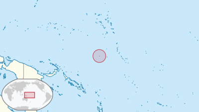
Nauru Location in World Map
This satellite photo shows you how small Nauru actually is.
Location Information of Nauru
Latitude and Longitude
Nauru is a small island country located in the Pacific Ocean, specifically in Micronesia. The island is situated at approximately 0.5228° S latitude and 166.9315° E longitude, making it one of the smallest countries in the world, both in land area and population. Nauru is located about 42 kilometers (26 miles) south of the Equator, and it is roughly 2,500 kilometers (1,550 miles) northeast of Australia.
The country consists of a single island that is roughly 21 square kilometers (8.1 square miles) in size, making it the third smallest country in the world after Vatican City and Monaco. The island is surrounded by a coral reef, and its geographical isolation gives it a unique set of environmental and cultural characteristics.
Capital City and Major Cities
Capital City: Yaren
The capital city of Nauru is Yaren, which is located on the southern coast of the island. Although Nauru does not have a designated capital in the traditional sense, Yaren functions as the administrative and government center of the country. It is the largest city in Nauru and serves as the main hub for the country’s political, economic, and social activities. Yaren is home to the Nauru Parliament, the presidential palace, and most government offices. The population of Yaren is approximately 1,100 people, as it also acts as a small community within Nauru’s small landmass.
Major Cities
Nauru has very few urban centers, as the island is sparsely populated with a total population of about 10,000 people. Most of the population lives in or around Yaren, but there are several smaller settlements scattered around the island:
- Aiwo: Located on the northern coast, Aiwo is one of the key settlements in Nauru. It is home to the country’s main port and has a population of around 1,500 people. Aiwo is also home to some government offices and the Nauru International Airport.
- Boe: Boe is located on the southeastern coast and has a population of about 500. The area is mainly residential, with some agricultural activities.
- Denigomodu: Located near the center of Nauru, Denigomodu is a smaller settlement where much of the island’s farming and industrial activities take place. It has a population of roughly 500 people.
- Ewa: Ewa is a town on the northwestern coast, known for being a residential area with a population of about 500. It is also a location for some government offices and services.
Time Zone
Nauru operates on Nauru Time (NRT), which is UTC +12:00. This places Nauru in the same time zone as Fiji, Kiribati, and New Zealand. Nauru does not observe daylight saving time, and thus the time remains consistent throughout the year.
Climate
Nauru has a tropical maritime climate, which means the island experiences warm temperatures and high humidity year-round. The island is subject to two main seasons: a wet season and a dry season.
1. Wet Season (November to March)
During the wet season, Nauru experiences higher humidity and increased rainfall. This period is characterized by occasional tropical storms and heavy rains. Temperatures during this season remain high, typically ranging between 28°C to 32°C (82°F to 90°F). Despite the rainfall, Nauru remains warm, and the wet season often brings thunderstorms, especially during the peak months of December through February.
2. Dry Season (April to October)
The dry season in Nauru is characterized by more moderate humidity levels and slightly cooler temperatures. This season lasts from April to October, with temperatures ranging from 26°C to 30°C (79°F to 86°F). Although the dry season sees less rainfall, some light showers can still occur. This is the peak season for travel, as the weather is more comfortable and conducive to outdoor activities.
3. Temperature
Nauru’s temperature is relatively consistent throughout the year, averaging between 28°C and 30°C (82°F to 86°F). The island’s location near the equator ensures that it experiences little variation in temperature, but the humidity levels can make it feel warmer than the actual temperature.
Economic Status
Nauru has a small and fragile economy that heavily depends on a few key industries, including phosphate mining, fisheries, and government aid. The country has one of the highest per capita incomes in the Pacific, but this wealth has not been evenly distributed, and the country faces significant economic challenges, particularly with the decline of its phosphate reserves.
1. Phosphate Mining
Phosphate mining has historically been the cornerstone of Nauru’s economy. The country has one of the world’s richest deposits of phosphate rock, which is used in the production of fertilizers. However, the phosphate reserves have been depleted in recent years, and the island faces the challenge of finding alternative sources of income. The phosphate industry remains a significant contributor to the national economy, but its decline has created an urgent need for diversification.
2. Fishing Industry
Nauru’s fishing industry is another important contributor to its economy. The country’s exclusive economic zone (EEZ) in the Pacific Ocean allows it to access rich fishing grounds. The government licenses foreign fishing vessels to operate in its waters, generating revenue from fishing licenses and tuna exports. The country also engages in some limited domestic fishing, primarily for tuna and seafood.
3. Government Aid
Due to its small size and limited resources, Nauru receives substantial foreign aid, especially from Australia. The country’s dependence on international financial assistance has become more pronounced following the depletion of its phosphate resources. This aid supports essential public services and government operations.
4. Tourism
Tourism plays a minor role in the Nauru economy, though the island has some natural attractions, including its pristine beaches, coral reefs, and historical sites. Nauru International Airport serves as the gateway for international visitors, though tourism infrastructure remains underdeveloped. The country is not a major tourist destination due to its isolation, limited amenities, and political challenges.
5. Challenges
Nauru faces significant economic challenges, including limited resources, unemployment, high dependence on foreign aid, and environmental degradation due to phosphate mining. The country’s government has focused on efforts to diversify the economy, but these efforts have yet to bear significant fruit.
Tourist Attractions
- Anibare Bay Anibare Bay is one of Nauru’s most beautiful natural attractions. It is a pristine beach with clear blue waters and coral reefs that are perfect for snorkeling and diving. The bay is also great for swimming, sunbathing, and relaxing by the sea. It is a popular spot for both locals and visitors to enjoy the natural beauty of Nauru.
- Nauru Phosphate Mine The Nauru Phosphate Mine is a unique tourist attraction in Nauru. It provides a glimpse into the country’s history and its once-thriving phosphate industry. The mining operations have dramatically altered the landscape, and visitors can view the pit mines, mining machinery, and the remains of phosphate extraction, which have become a testament to Nauru’s industrial past.
- Nauru National Museum The Nauru National Museum offers visitors a chance to explore the island’s cultural heritage and history. The museum showcases a collection of artifacts, traditional artifacts, photographs, and exhibits related to Nauru’s pre-colonial and colonial past. It provides a deeper understanding of the island’s development, culture, and independence.
- Nauru’s Bird Sanctuary Nauru is home to a variety of bird species, including the Nauru lorikeet and other tropical birds. The island’s bird sanctuary offers an opportunity for birdwatching and is one of the few places on the island where one can experience the local wildlife in its natural habitat.
- Japanese Caves During World War II, the island was occupied by the Japanese, and the Japanese Caves were built as bunkers. These historical sites remain an interesting attraction for visitors interested in World War II history. The caves provide a glimpse into the war-time history of the island and are scattered around different locations on the island.
Visa Requirements for U.S. Citizens
U.S. citizens require a visa to enter Nauru. However, for short stays (up to 30 days), U.S. citizens can obtain a visa on arrival. To enter Nauru, U.S. citizens need a valid passport, a completed visa application form, and a return or onward ticket. Proof of sufficient funds to cover the stay may also be requested. For longer stays, such as for employment or residence, a visa must be obtained in advance through the Nauru Department of Immigration.
Distance to New York City and Los Angeles
Distance to New York City
The distance from New York City to Nauru is approximately 14,500 kilometers (9,000 miles). Flights typically require at least one stopover, with travel times ranging from 18 to 20 hours, depending on layover duration and specific flight routes.
Distance to Los Angeles
The distance from Los Angeles to Nauru is approximately 12,500 kilometers (7,800 miles). Flights from Los Angeles to Nauru generally require at least one stopover, with total travel times typically ranging from 15 to 17 hours, depending on the specific flight path and layover duration.
Nauru Facts
| Size | 21 km² |
| Residents | 11,000 |
| Languages | Nauruan and English |
| Capital | none, seat of government Yaren |
| Longest river | – |
| Highest mountain | Command Ridge (61 m) |
| Currency | Australian dollar |


