Where is Kazakhstan Located?
Where is Kazakhstan located on the map? Kazakhstan is an independent nation located in Central Asia. Check out the following images to see location of Kazakhstan on maps.
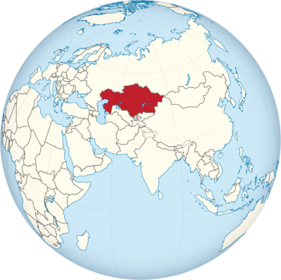
Kazakhstan Location in World Map
Here you can see where Kazakhstan is.
Location Information of Kazakhstan
Kazakhstan, the largest landlocked country in the world, is located in Central Asia. It spans an immense area, bordered by Russia to the north, China to the east, Kyrgyzstan, Uzbekistan, and Turkmenistan to the south, and the Caspian Sea to the west. Kazakhstan is geographically significant as it connects Eastern Europe with Central Asia and plays an important role in regional geopolitics. The country’s vast steppe, mountainous regions, and desert landscapes give it a unique geographical character.
Latitude and Longitude
Kazakhstan lies roughly between 40° N to 55° N latitude and 46° E to 87° E longitude. The country is situated over a large expanse of land, extending from the Caspian Sea in the west to the Altai Mountains in the east, and from the steppes of northern Kazakhstan to the deserts in the south. Its capital city, Astana (renamed Nur-Sultan in 2019, though the city is now once again called Astana as of 2022), lies at approximately 51° 10′ N latitude and 71° 25′ E longitude.
Capital City and Major Cities
Kazakhstan’s capital city, Astana, formerly known as Akmolinsk, Tselinograd, and Akmola, was renamed to Nur-Sultan in 2019 after the first president, Nursultan Nazarbayev. However, in 2022, it reverted back to its original name, Astana. The city is a political and cultural hub, and its futuristic architecture, including the Bayterek Tower and the Palace of Peace and Reconciliation, make it a symbol of Kazakhstan’s development.
Astana (Nur-Sultan)
Astana, the capital, is a modern city characterized by bold, cutting-edge architecture. It was chosen as the capital in 1997 by President Nazarbayev due to its more centralized location in the country, which aimed to facilitate development and balance the distribution of the nation’s population. Over the years, Astana has grown into a political, economic, and cultural center, hosting important international conferences and diplomatic meetings.
The city is also known for its dramatic weather conditions, with extreme temperature variations. In summer, temperatures can rise above 30°C (86°F), while in winter, temperatures can plunge below -40°C (-40°F). Despite these extremes, the city’s development into a key urban center is a significant achievement for Kazakhstan.
Almaty
Almaty, the former capital, remains Kazakhstan’s largest city and its cultural and financial heart. Located in the southeastern part of the country near the Tien Shan Mountains, Almaty is the country’s commercial center. It is home to many international companies, financial institutions, and cultural landmarks, such as the Zenkov Cathedral, Panfilov Park, and the Central State Museum. Almaty is known for its beautiful natural surroundings, offering residents and tourists access to mountain hiking, skiing, and nature reserves.
The city has a more temperate climate than Astana, with hot summers and cold winters. Almaty serves as the gateway to some of the most beautiful outdoor landscapes in Central Asia, such as Big Almaty Lake and Shymbulak Ski Resort.
Shymkent
Shymkent, located in southern Kazakhstan near the border with Uzbekistan, is one of the country’s largest cities. Historically significant as a center of trade and culture in Central Asia, Shymkent is now an important industrial and commercial city. The city has a more temperate climate and a strategic location that has made it a vital economic hub, particularly for trade with neighboring countries.
Karaganda
Karaganda, located in the central part of Kazakhstan, is one of the country’s major industrial cities. Known for its mining and metallurgical industries, Karaganda also has a rich cultural heritage. The region is famous for the Karaganda mines, which once housed a large population of laborers in Soviet times. Today, the city is an important center for industry, education, and healthcare.
Aktobe
Aktobe is a city in western Kazakhstan, important for its natural resources, particularly oil and gas production. It serves as an industrial and commercial hub in the region. Aktobe is also known for its proximity to the Ural River and its strategic importance in connecting Kazakhstan to the Caspian Sea via Russia.
Time Zone
Kazakhstan spans two time zones: Kazakhstan Time (UTC +5:00) and UTC +6:00. The country’s time zones are particularly significant given its size, with the western part of Kazakhstan being in UTC +5 and the eastern part, including the capital Astana, operating on UTC +6. Kazakhstan does not observe Daylight Saving Time (DST), meaning its time remains consistent throughout the year.
Climate
Kazakhstan has a continental climate, with cold winters and hot summers. The country’s geography, with expansive steppe and desert regions, results in wide temperature fluctuations. The steppe climate dominates much of the country, while the mountainous regions of the southeast, near the border with China, experience a mountain climate with cooler conditions and more precipitation.
Winter
Kazakhstan’s winters are harsh, with temperatures dropping as low as -40°C (-40°F) in some areas, particularly in the northern and central parts of the country. Snowfall is common, and temperatures in cities like Astana can remain below freezing for extended periods from November to March. The extreme winter temperatures make it necessary to have well-developed infrastructure and heating systems.
Summer
Summers in Kazakhstan are hot, particularly in the lowland regions. Average summer temperatures in cities like Almaty and Shymkent can reach 30-35°C (86-95°F), with the southern areas experiencing even higher temperatures. The arid deserts in the west and south can become very hot, with occasional heat waves pushing temperatures well above 40°C (104°F).
Rainfall and Precipitation
Kazakhstan’s climate is relatively dry, especially in the central and northern parts of the country. Rainfall is more common in the east and southeast, particularly near the mountainous regions. Most of the precipitation occurs in late spring and summer, with the southern and central parts of the country receiving very little annual rainfall. This arid climate limits agriculture in certain areas but does not affect the country’s vast natural resource wealth.
Economic Status
Kazakhstan is classified as an upper-middle-income country with a diverse economy, driven by natural resources, agriculture, and heavy industries. Kazakhstan is rich in mineral resources, including oil, gas, coal, uranium, and precious metals, and it is one of the world’s top producers of uranium. The country’s economy has grown steadily in recent years, although it faces challenges related to global commodity prices, reliance on oil, and the need for economic diversification.
Key Economic Sectors
- Energy and Natural Resources: Kazakhstan has vast reserves of oil and natural gas. The country is a major oil producer in Central Asia and exports significant quantities of crude oil, primarily to China, Russia, and Europe. The Kazakhstan National Oil and Gas Company (KazMunayGas) plays a major role in the sector. The country is also a leader in uranium production, which gives it a strategic advantage in the global nuclear energy market.
- Agriculture: Agriculture remains an important part of the economy, especially in the rural areas of Kazakhstan. Key agricultural products include grain, wheat, barley, and livestock, particularly cattle and sheep. Kazakhstan is a major global exporter of wheat, and its agricultural sector is integral to the economy. The country has also developed extensive irrigation systems to support the agricultural sector.
- Manufacturing and Industry: Kazakhstan has a well-developed industrial base, primarily in metallurgy, mining, and machine-building. The Karaganda region is known for its mining industry, particularly coal extraction, while the Pavlodar region is known for its heavy industrial enterprises. The manufacturing sector in Kazakhstan has been expanding as the country seeks to diversify its economy beyond oil.
- Finance and Services: Kazakhstan has a growing financial sector, with Almaty serving as the financial capital of Central Asia. The government has worked to improve the banking system and increase foreign investment. The country has also become a regional hub for logistics and trade.
Challenges
Kazakhstan faces a number of economic challenges, including dependence on oil prices, income inequality, and poverty in rural areas. There is also an ongoing need for economic diversification and reducing the country’s reliance on natural resources. Political stability and corruption remain concerns for investors, though the government has taken steps to improve governance and attract foreign investment.
Tourist Attractions
Kazakhstan is not yet a major global tourist destination, but its natural beauty, rich cultural heritage, and unique landscapes offer great potential. The country’s vast steppe, majestic mountains, and remote deserts provide opportunities for adventure tourism, while its historical and cultural sites highlight the country’s ancient and modern heritage.
Charyn Canyon
Charyn Canyon, located in the southeastern part of the country, is often compared to the Grand Canyon due to its striking red rock formations and deep ravines. The canyon stretches over 80 kilometers (50 miles) and features some of the most stunning natural scenery in Kazakhstan. Visitors can hike, camp, and explore the surrounding area.
Altai Mountains
Located in the far eastern part of Kazakhstan, the Altai Mountains offer a unique mix of landscapes, including snow-capped peaks, alpine lakes, and forests. The region is popular for trekking, skiing, and wildlife viewing, with an abundance of flora and fauna. The Altai mountains are also home to several ancient petroglyphs and historical sites.
Mausoleum of Khoja Ahmed Yasawi
The Mausoleum of Khoja Ahmed Yasawi in Turkestan is a UNESCO World Heritage site. It is a major pilgrimage site for Muslims in Central Asia and is considered one of the finest examples of Timurid architecture. The mausoleum attracts visitors interested in both history and religion.
Lake Balkhash
Lake Balkhash, one of the largest lakes in Kazakhstan, is unique because it is divided into two distinct parts: one part is fresh water, while the other is saline. The lake is a popular destination for fishing, boating, and relaxing along its shores. The surrounding area is also known for its vast steppes and wildlife.
Visa Requirements for U.S. Citizens
U.S. citizens who wish to visit Kazakhstan for tourism or business purposes are required to obtain a visa before arrival. Travelers must apply for an eVisa, which allows stays of up to 30 days for tourism purposes. The eVisa can be obtained online, and applicants will need to provide personal details, travel information, and a valid passport.
In addition to the eVisa, travelers must also meet specific health and security requirements, including vaccination certificates and proof of travel insurance. For stays longer than 30 days, or for purposes such as work or study, a traditional visa must be obtained through a Kazakh embassy or consulate.
Distance to New York City and Los Angeles
- From New York City to Astana (Kazakhstan): The flight distance from John F. Kennedy International Airport (JFK) to Nursultan Nazarbayev International Airport (Astana) is approximately 10,800 kilometers (6,700 miles). The flight duration is around 12-14 hours, depending on the number of stopovers.
- From Los Angeles to Astana: The distance from Los Angeles International Airport (LAX) to Astana is approximately 11,000 kilometers (6,835 miles), and the flight time is usually around 13-15 hours, depending on layovers. Flights generally require at least one stopover, often in major European hubs or Moscow.
Kazakhstan Facts
| Size | 2,724,900 km² |
| Residents | 18.3 million |
| Languages | Kazakh and Russian |
| Capital | Nursultan (formerly Astana, renamed in 2019) |
| Longest river | Irtysh (1,700 km) |
| Highest mountain | Khan Tengri (7,010 m) |
| Currency | Tenge |


