Where is Georgia Located?
Where is Georgia located on the map? Georgia is an independent nation located in Western Asia. Check out the following images to see location of Georgia on maps.
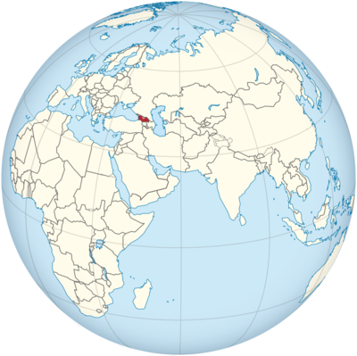
Georgia Location in World Map
Here you can see where Georgia is. On the map you can also see where the breakaway provinces of Abkhazia and South Ossetia are located. Ajaria in the southwest is still part of Georgia as an autonomous republic.
Location Information of Georgia
Georgia, located at the intersection of Europe and Asia, is a country rich in history, culture, and natural beauty. It is bordered by Russia to the north, Turkey and Armenia to the south, Azerbaijan to the southeast, and the Black Sea to the west. With a diverse landscape ranging from mountain ranges to fertile valleys, Georgia has become a popular destination for travelers, historians, and adventurers alike.
Latitude and Longitude
Georgia is positioned between 41° and 43° N latitude and 41° and 46° E longitude. The country’s strategic location on the southern edge of the Caucasus Mountains means that it has historically been a crossroads for different cultures, making it a region of great significance in both historical and geopolitical contexts.
Capital City and Major Cities
Tbilisi (Capital City)
Tbilisi is the capital and largest city of Georgia, sitting on the banks of the Kura River. Known for its diverse architecture and vibrant culture, Tbilisi has a history that spans over 1,500 years. It serves as the political, cultural, and economic hub of the country.
- Old Town (Altstadt): The Old Town is a UNESCO World Heritage site known for its cobblestone streets, charming houses with wooden balconies, and ancient churches. Visitors can explore the Narikala Fortress, a key historical landmark dating back to the 4th century.
- Rustaveli Avenue: This main thoroughfare in Tbilisi is home to a number of important cultural institutions, including the Georgian National Museum, the Tbilisi Opera House, and Freedom Square.
- Holy Trinity Cathedral of Tbilisi (Sameba): The largest Orthodox cathedral in Georgia, this imposing structure was completed in 2004 and offers panoramic views of the city from its hilltop location.
- Tbilisi Botanical Garden: A serene and expansive garden located near the Narikala Fortress, perfect for a relaxing walk in nature amidst the city’s hustle and bustle.
Batumi
Batumi is a coastal city located on the Black Sea, serving as Georgia’s second-largest city. Known for its Mediterranean climate and modern infrastructure, Batumi is rapidly becoming a popular tourist destination.
- Batumi Boulevard: The long promenade stretches along the seafront and is lined with palm trees, cafes, and modern sculptures. It is perfect for a stroll by the sea.
- Batumi Botanical Garden: One of the largest botanical gardens in the Caucasus region, featuring diverse plant species from around the world.
- Ali and Nino Statue: A moving sculpture depicting a love story between a Georgian princess and an Azerbaijani man, symbolizing the country’s cultural blend and history.
Kutaisi
Kutaisi is one of the oldest cities in Georgia, located in the western part of the country. It is the administrative center of the Imereti region and has played a significant role in Georgia’s history.
- Bagrati Cathedral: A UNESCO World Heritage site, this cathedral was originally built in the 11th century and is one of Georgia’s most iconic religious sites.
- Gelati Monastery: A medieval monastic complex located near Kutaisi, also a UNESCO World Heritage site, known for its stunning mosaics and frescoes.
- Prometheus Cave: A famous natural landmark, the cave system is filled with unique stalactites and stalagmites and is a popular destination for adventurous travelers.
Zugdidi
Zugdidi is the capital of the Samegrelo-Zemo Svaneti region, located in the western part of Georgia. It is known for its lush green landscapes and proximity to the Caucasus Mountains. The town is a gateway to the highland regions of Georgia.
- Dadiani Palace: A historic palace that once belonged to the noble Dadiani family, offering a glimpse into Georgia’s royal past.
- Martvili Canyon: Known for its picturesque views and crystal-clear waters, this canyon offers boat tours and opportunities for hiking.
Time Zone
Georgia operates on Georgia Time (GET), which is UTC+4 hours. The country does not observe Daylight Saving Time (DST), so the time remains constant throughout the year. This places Georgia four hours ahead of Coordinated Universal Time (UTC), and it is on the same time zone as countries like Armenia and Azerbaijan.
Climate
Georgia has a varied climate, which is influenced by its topography, proximity to the Black Sea, and the Caucasus Mountains. The country’s climate can be divided into several zones, ranging from humid subtropical along the coast to alpine in the mountains.
Coastal Climate (Batumi, Black Sea)
The western coastal region of Georgia has a humid subtropical climate with warm, humid summers and mild winters. The annual rainfall is high, especially in Batumi, which receives some of the highest rainfall amounts in the country.
- Summer temperatures: Average temperatures range from 25°C to 30°C (77°F to 86°F), making it a popular summer resort destination.
- Winter temperatures: Winter is milder, with temperatures rarely falling below 5°C (41°F).
Continental Climate (Tbilisi, Central Georgia)
The central and eastern parts of Georgia, including the capital city of Tbilisi, experience a continental climate. Summers are hot and dry, while winters can be quite cold with occasional snowfall, particularly in the mountain areas.
- Summer temperatures: Daytime temperatures during the summer months can reach 30°C to 35°C (86°F to 95°F).
- Winter temperatures: Winter temperatures can drop to -5°C to -10°C (23°F to 14°F), especially in the more mountainous regions.
Alpine Climate (Svaneti, Kazbegi)
Georgia’s higher-altitude regions, including areas in the Caucasus Mountains, have an alpine climate. These areas experience cool summers and harsh, snowy winters, attracting tourists year-round for skiing, hiking, and mountaineering.
- Summer temperatures: In the mountains, temperatures during summer are generally cool, ranging from 10°C to 20°C (50°F to 68°F).
- Winter temperatures: In winter, temperatures can plunge to -15°C to -20°C (5°F to -4°F).
Economic Status
Georgia is considered a developing country with a growing economy. Over the past few decades, it has made significant strides in reforming its economy, particularly in the areas of infrastructure, agriculture, and tourism. It is known for being one of the most business-friendly environments in the region.
Key Economic Sectors
- Agriculture: Agriculture plays an important role in Georgia’s economy. The country is known for producing wine, fruits, vegetables, and grains. Georgian wine, which is made from over 500 indigenous grape varieties, is a key export product and a point of cultural pride.
- Tourism: Georgia’s unique blend of natural beauty, historical landmarks, and cultural heritage has made it an increasingly popular tourist destination. Tourism accounts for a significant portion of the country’s GDP, with visitors flocking to sites like Tbilisi, the Caucasus Mountains, and Batumi.
- Energy: Georgia has a well-developed energy sector, with hydroelectric power playing a major role in the country’s electricity production. The country is also exploring natural gas production and renewable energy sources.
- Industry and Services: The manufacturing sector in Georgia is growing, particularly in the areas of textiles, construction materials, and processed foods. The services sector, including finance and banking, is also expanding.
Unemployment and Income
Georgia has made notable progress in reducing unemployment in recent years, but the rate still hovers around 12-15%. The average monthly wage in Georgia is relatively low by Western standards but has been increasing steadily. The country’s cost of living is low, making it an attractive destination for expatriates and tourists.
Tourist Attractions
Georgia offers a wide range of tourist attractions, from ancient historical sites to stunning natural landscapes.
Uplistsikhe Cave Town
One of Georgia’s most remarkable archaeological sites, Uplistsikhe is an ancient rock-hewn town dating back to the early Iron Age. Visitors can explore its caves, tunnels, and ancient structures, which reflect the country’s long and varied history.
Vardzia
Vardzia is a cave monastery complex built into the cliffs of the Erusheti Mountain in southern Georgia. The monastery, which dates back to the 12th century, contains hundreds of rooms, tunnels, and churches.
Kazbegi National Park
Located in the heart of the Caucasus Mountains, Kazbegi National Park is famous for its dramatic landscapes, including Mount Kazbek, one of the highest peaks in Georgia. The Gergeti Trinity Church, perched on a hill with a view of the mountain, is one of the most photographed landmarks in the country.
Svaneti
Svaneti is a remote and rugged region in the Caucasus Mountains, known for its medieval villages and tower houses. The region is a UNESCO World Heritage site and offers excellent hiking, mountaineering, and cultural experiences.
Visa Requirements for U.S. Citizens
U.S. citizens can enter Georgia without a visa for up to one year for tourism, business, or personal visits. Travelers need a valid U.S. passport, and there are no special requirements for entry or departure. If a U.S. citizen plans to stay longer than 365 days, they will need to apply for an extension or a residence permit.
Distance to New York City and Los Angeles
- New York City to Tbilisi: The distance between John F. Kennedy International Airport (JFK) and Tbilisi International Airport (TBS) is approximately 6,000 miles (9,650 kilometers). A direct flight typically takes 11 to 12 hours.
- Los Angeles to Tbilisi: The distance between Los Angeles International Airport (LAX) and Tbilisi International Airport (TBS) is about 6,600 miles (10,600 kilometers). The flight duration is approximately 12 to 13 hours.
Georgia Facts
| Size | 69,700 km² |
| Residents | 3.71 million |
| Language | Georgian |
| Capital | Tbilisi (Tbilisi) |
| Longest river | Kura (in Georgia 351 km, total length 1,364 km) |
| Highest mountain | Shchara (5,200 m) |
| Currency | lari |


