What is the Capital of France? Paris
Capital City of France: Paris
City Overview
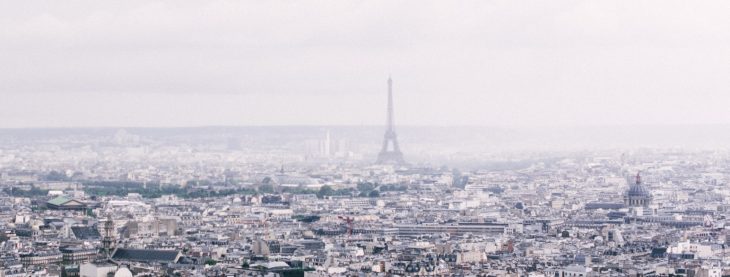
Paris, the capital city of France, is one of the most famous and influential cities in the world. Located in the northern part of the country along the Seine River, Paris has been a center of culture, art, fashion, and intellectual thought for centuries. The city is often referred to as “The City of Light” due to its historical role as a hub of education and the Enlightenment in the 18th century, as well as the early adoption of street lighting.
Paris has a rich history that spans over two millennia, with origins dating back to the 3rd century BC when it was known as Lutetia, a small Gallic settlement. Over the centuries, Paris evolved into a powerful city-state under Roman rule, a medieval kingdom, and eventually, the capital of France. Throughout its history, Paris has been the site of major political, cultural, and historical events, including the French Revolution, the rise and fall of Napoleon Bonaparte, and the creation of the modern French Republic.
Today, Paris is not only the political and administrative center of France but also a global center for art, fashion, entertainment, and commerce. The city is renowned for its world-class museums like the Louvre, its iconic architecture, and its historical neighborhoods. With a population of over 2 million people within the city proper and around 12 million people in the metropolitan area, Paris is one of the largest cities in Europe and a bustling global metropolis.
Key Facts about Paris:
- Area: 105.4 square kilometers (40.7 square miles)
- Population: Approximately 2.2 million (2023 estimate)
- Time Zone: Central European Time (CET) (UTC +1) and Central European Summer Time (CEST) (UTC +2)
- Highest Mountain: Mont Blanc (4,808 meters or 15,774 feet), located in the French Alps, is the highest mountain in France, though it is about 480 kilometers southeast of Paris.
- Longest River: The Seine River is the longest river flowing through Paris, stretching for approximately 777 kilometers (483 miles) across northern France.
Paris has a vast and sophisticated transportation network, including an extensive metro system, buses, and commuter rail that links the city to the rest of the country. It is also served by two major airports, Charles de Gaulle and Orly, making it one of the busiest air transport hubs in the world.
Major Landmarks in Paris
- Eiffel Tower
The Eiffel Tower is perhaps the most iconic symbol of Paris and one of the most recognized structures in the world. Completed in 1889 for the Exposition Universelle (World’s Fair), it was initially criticized by many but has since become a beloved landmark. Standing 330 meters (1,083 feet) tall, it offers panoramic views of Paris from its observation decks. - Louvre Museum
The Louvre is the largest and one of the most famous art museums in the world. Located on the banks of the Seine River, the Louvre houses an extensive collection of art, including the Mona Lisa, Venus de Milo, and countless masterpieces spanning from ancient civilizations to the modern era. It was originally a royal palace and has been a museum since 1793. - Notre-Dame Cathedral
Notre-Dame de Paris is one of the most famous Gothic cathedrals in the world, located on the Île de la Cité. Built between the 12th and 14th centuries, the cathedral is renowned for its stunning architecture, stained glass windows, and its role in French history, particularly during the French Revolution and the reign of Napoleon. - Sacré-Cœur Basilica
Located at the highest point in Paris, on Montmartre Hill, the Basilica of the Sacred Heart (Sacré-Cœur) offers both religious significance and breathtaking views of the city. The basilica’s white dome is one of the most recognizable features of the Parisian skyline. - Champs-Élysées and Arc de Triomphe
The Avenue des Champs-Élysées is one of the most famous streets in the world, lined with theaters, cafés, and shops. It stretches from the Place de la Concorde to the Arc de Triomphe, a monument built by Napoleon Bonaparte to honor his military victories. The arc is situated at the western end of the Champs-Élysées and offers a spectacular vantage point of the city. - Musée d’Orsay
Housed in a former railway station, the Musée d’Orsay is dedicated to French art from the 19th and early 20th centuries. It is famous for its impressive collection of Impressionist and Post-Impressionist masterpieces by artists such as Monet, Van Gogh, and Degas. - Pantheon
Located in the Latin Quarter, the Pantheon is a neoclassical monument that serves as both a church and a mausoleum. It is the final resting place for many of France’s greatest figures, including Voltaire, Rousseau, and Victor Hugo.
Climate Overview
Paris experiences a temperate oceanic climate, characterized by mild winters and warm summers. The city has relatively moderate temperatures year-round, though it can occasionally experience extreme weather events, such as heatwaves in the summer or cold spells in winter. Precipitation is spread evenly throughout the year, with the wettest months being from May to August.
| Month | Average Temperature (°C) | Average Precipitation (mm) | Avg Sunny Days |
|---|---|---|---|
| January | 5 | 48 | 3 |
| February | 6 | 42 | 4 |
| March | 9 | 47 | 5 |
| April | 11 | 50 | 6 |
| May | 15 | 56 | 7 |
| June | 18 | 53 | 8 |
| July | 20 | 58 | 9 |
| August | 20 | 57 | 8 |
| September | 17 | 51 | 7 |
| October | 12 | 56 | 5 |
| November | 8 | 54 | 4 |
| December | 5 | 49 | 3 |
Other Cities That Served as Capital in France’s History
1. Soissons (Before 508 – 508)
Soissons was the capital of the Merovingian Kingdom of the Franks before Paris took over the role. King Clovis I established Soissons as the capital after his victory at the Battle of Soissons. In 508, Clovis moved the capital to Paris, where it has remained ever since.
2. Rheims (Before 508 – 10th Century)
Rheims was a historically significant city, especially for its role in the coronation of French kings. While it was never a permanent capital, it held considerable influence in the early years of the French monarchy. It was used as a political center and a place for royal ceremonies.
Country Facts
France, officially known as the French Republic, is one of the largest and most influential countries in Europe and the world. With a rich cultural history, a global presence in politics, economics, and the arts, and a strong role in the European Union, France is known for its contributions to world civilization. Paris, its capital, is not only the political center but also a cultural and financial epicenter with global influence.
- Population: Approximately 67 million (2023 estimate)
- Area: 551,695 square kilometers (213,011 square miles)
- Largest City: Paris
- Currency: Euro (€)
- Official Language: French
- ISO Country Code: FR
- Timezone: Central European Time (CET) (UTC +1) and Central European Summer Time (CEST) (UTC +2)
France has a diverse geography, ranging from the alpine regions in the southeast to the Mediterranean coast and the rolling plains in the north and west. Its economy is one of the largest in the world, with strong industries in aerospace, automotive manufacturing, fashion, and luxury goods. France is a founding member of the European Union, NATO, the United Nations, and the World Trade Organization, and it is a permanent member of the UN Security Council. Paris continues to be a leading city in terms of diplomacy, culture, and global influence.


