Eritrea Facts
Eritrea, state of northeastern Africa; 121,000 km², 3.2 million residents (2019).Eritrea borders Sudan in the northwest, Ethiopia in the southwest and Djibouti in the south, and has a coast to the Red Sea in the east. The capital is Asmera (712,000 residents, 2012).
Country facts
- State of Eritrea / Eritrea
- Country abbreviation: ER
- Area: 121 000 km²
- Population (2019): 3.2 million residents
- Capital: Asmera
- Main languages: Tigrinese, Arabic, English
- State: Republic
- Head of State and Head of Government: Isaias Afwerki (President)
- Per capita GDP (2014): US $ 755
- GNI per capita (2014): US $ 680
- Currency unit: 1 nakfa = 100 cents
- Currency code: ERN
- Country number (telephony): 291
- Internet domain names: er
- Time difference compared to Sweden: +2
- National Day: May 24 (Independence Day, 1993)
Nature
- Land use: forest (5%), agricultural land (3%), other (92%)
- Highest mountain: Amba Soira (3,010 m asl)
Population
- Population density (2019): 26 residents per km²
- Natural population growth (2019): 2.4%; birthrate 31 ‰, death count 7 ‰
- Age structure (2019): 0-14 years (42%), 15-64 (54%), 65- (4%)
- Life expectancy (2019): men 63 years, women 68 years
- Infant mortality (2019): 36 per 1,000 live births
- Population forecast 2050: 6 million residents
- HDI (2017): 0.440 (place 179 of 189)
- Urbanization rate (2019): 40%
- Most populous cities (2012): Asmera (712,000 residents), Aseb (101,300)
Business
- Industry’s contribution to GDP (2017): agriculture (12%), industry (30%), service (58%)
- Exports (2017): US $ 624 million
- Main export products: minerals, livestock, sorghum, textiles
- Main exporting countries: China, South Korea
- Imports (2017): US $ 1,127 million
- Main import products: machinery, oil, food
- Main importing countries: United Arab Emirates, China, Saudi Arabia
- Railway network (2018): 300 km
Geography
Location and Borders
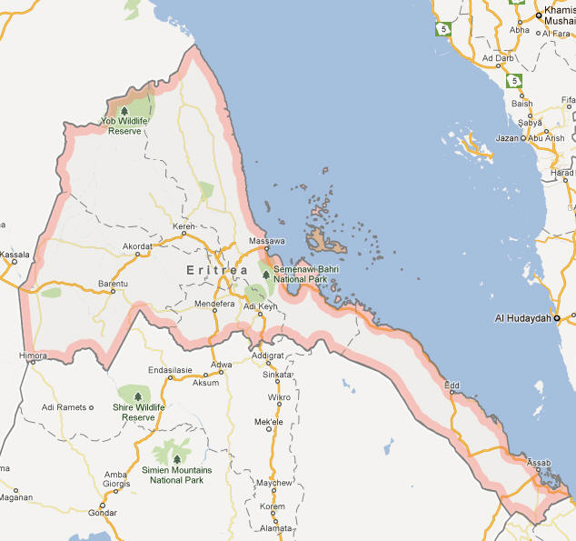
Eritrea is a country located in the Horn of Africa, bordered by Sudan to the west, Ethiopia to the south, and Djibouti to the southeast. To the northeast, Eritrea has a long coastline along the Red Sea, which has historically provided it with strategic access to the Arabian Peninsula and the broader Middle East. Eritrea also shares maritime boundaries with Saudi Arabia and Yemen, across the Red Sea. The country is situated at the crossroads of Africa and the Middle East, making it an important geographical region for trade and cultural exchanges.
Eritrea’s land area covers approximately 117,600 square kilometers (45,406 square miles), making it slightly larger than Guinea. Its size and geographical diversity make it one of Africa’s most varied countries in terms of terrain and ecosystems. Despite its small size, Eritrea’s diverse geographical landscape has allowed it to become a country with both mountainous and coastal environments, with areas that range from semi-arid deserts to fertile plateaus.
Topography and Natural Features
Eritrea’s topography is highly diverse, with coastal plains, highland plateaus, and desert regions all making up parts of the country’s landmass. The western half of the country is dominated by the Eritrean Highlands, which rise steeply from the lowlands to form a highland plateau. This mountainous region, which includes the country’s highest point, Mount Soira (3,018 meters or 9,902 feet), is known for its dramatic landscapes, with deep valleys, riverbeds, and fertile highland plains that provide the best agricultural land in the country.
To the east, the highlands slope down into the coastal plains, which are hot and arid, characteristic of a desert environment. These plains stretch along the Red Sea, and much of the coastal region is characterized by sandy shores, salt flats, and rocky outcrops. The coastal zone is important for fishing and has access to vital shipping routes. There are also several islands off the coast, such as the Dahlak Archipelago, known for its marine biodiversity and scenic landscapes.
Eritrea’s river systems are relatively limited, but the main river in the country is the Mereb River, which forms part of the border with Ethiopia. The country is also home to several seasonal rivers, which flow in the rainy season, and these are crucial for irrigation and agriculture in the otherwise dry regions.
Climate and Seasonal Variation
Eritrea has a primarily hot and dry climate, with significant regional variations due to its diverse topography. The highland areas experience a more temperate climate with cooler temperatures, particularly in the evenings, due to their higher elevation. The central plateau, including the capital city of Asmara, enjoys moderate temperatures ranging from 20°C to 25°C (68°F to 77°F) year-round, making it an ideal location for human habitation compared to the more extreme climates elsewhere in the country.
In contrast, the coastal plains and the lowlands, such as those around Massawa on the Red Sea, experience a much hotter climate, often exceeding 30°C (86°F) during the summer months. These areas are characterized by higher humidity, especially near the Red Sea, and are subject to intense heat, particularly in the summer.
Eritrea has two primary seasons: the wet season, which lasts from June to September, and the dry season, which extends from October to May. The wet season brings the majority of the country’s rainfall, which is essential for agriculture in the highland and lowland regions. However, rainfall is not uniform across the country, with the highlands receiving more consistent rainfall and the coastal and desert areas receiving very little precipitation. Droughts can be a significant problem, particularly in the more arid parts of Eritrea, leading to food insecurity.
People
Population and Demographics
Eritrea has an estimated population of around 3.5 million people. The population is relatively young, with a significant portion of the population under the age of 30. This youthful demographic provides the country with both opportunities and challenges, as it will need to ensure adequate resources for education, healthcare, and employment to meet the needs of its growing population.
The country is ethnically diverse, with several ethnic groups, each with their own languages, cultures, and traditions. The largest ethnic group is the Tigrinya, who make up about 55% of the population and predominantly reside in the highland areas. Other significant ethnic groups include the Tigre (30%), who live in the lowland areas, and smaller groups such as the Saho, Bilen, Kunama, and Rashaida. There are also some Arab and Cushitic ethnic groups in the coastal regions.
Eritrea’s diversity in language, religion, and culture has shaped the country’s social and political landscape. While most people identify with one of these ethnic groups, intermarriage and a shared national identity have created a society that is complex yet united in many respects. The country’s small population relative to its size makes the issues of ethnic and regional unity particularly important for political stability.
Languages
Eritrea is home to nine recognized languages, and it is a multilingual society where several languages are spoken in daily life. The primary languages are Tigrinya, spoken by the majority of the population, and Arabic, which is widely used in trade, commerce, and government. Other languages spoken in Eritrea include Tigre, Saho, Bilen, Kunama, Rashaida, and other Cushitic and Nilo-Saharan languages.
Tigrinya is the most commonly spoken language, used by the Tigrinya people who primarily reside in the highland areas. It is also the language of instruction in schools and is used in the media and government. Arabic is used extensively in the coastal areas, particularly in Massawa and Assab, where trade and interactions with neighboring countries have historically been important. In addition to Tigrinya and Arabic, English is also widely understood, especially in urban areas and among educated populations.
Despite the linguistic diversity, Eritrea is a relatively cohesive society, with many Eritreans learning multiple languages, particularly Tigrinya and Arabic, as part of their daily life.
Religion
The majority of the population in Eritrea adheres to Christianity, with both the Ethiopian Orthodox Church and Roman Catholicism having a significant presence. The Ethiopian Orthodox Tewahedo Church is the largest Christian denomination in Eritrea, particularly among the Tigrinya-speaking population. The church has a long and deep-rooted history in Eritrea, with ancient churches and monasteries found across the country, especially in the highland regions.
Roman Catholicism is practiced by a smaller portion of the population, and there is also a growing Protestant community, particularly among Eritreans of Ethiopian and European descent. Eritrea is also home to a significant Muslim population, particularly among the Tigre, Rashaida, and other coastal groups. Islam has a long history in Eritrea, dating back to the early centuries of the Islamic era, and has influenced the cultural and political dynamics of the coastal regions.
Religious practice in Eritrea is important to the social fabric, and religious holidays such as Christmas (for Christians) and Eid al-Fitr (for Muslims) are celebrated with community gatherings, feasts, and festivals. Religious tolerance has historically been a feature of Eritrean society, although the government’s approach to religion has at times led to tensions, particularly regarding the registration and activities of religious groups outside the state-run religious institutions.
Economy
Overview
Eritrea’s economy is largely driven by agriculture, mining, and remittances from the Eritrean diaspora. The country has experienced slow economic growth due to factors such as limited infrastructure, political instability, and the long-lasting effects of war. However, in recent years, the government has attempted to diversify the economy, particularly by focusing on mineral extraction, including gold, copper, and zinc.
Agriculture is the backbone of the Eritrean economy, with the majority of the population involved in farming and livestock production. The country produces crops such as barley, millet, wheat, sorghum, and vegetables, with coffee being one of the most important cash crops. However, the agricultural sector faces challenges, including inadequate irrigation, unreliable rainfall, and soil degradation, which hinder overall productivity.
Eritrea’s mining sector has shown potential, particularly with the discovery of substantial mineral deposits, including gold, copper, and zinc. The country has attracted foreign investment in the mining sector, though the sector is still underdeveloped, and there are concerns about the environmental impact of mining activities.
Eritrea also receives remittances from the Eritrean diaspora, which has historically been a major source of income for many families. These remittances have supported household consumption and helped finance infrastructure and development projects in the country.
Agriculture and Natural Resources
Agriculture is essential to the Eritrean economy, especially in rural areas where the majority of the population lives. The country’s agricultural production focuses on subsistence farming, with small-scale farming of crops such as millet, sorghum, and barley. These crops provide the majority of food consumed by the population, while cash crops like coffee and cotton are grown for export.
Livestock farming is also an important part of the economy, especially in rural areas. Eritrea is home to cattle, goats, sheep, and camels, which are used for both meat and milk production. Despite its potential, agriculture in Eritrea faces challenges such as water scarcity, droughts, and land degradation due to poor farming practices.
Eritrea’s mineral resources are among the country’s greatest natural assets. The country has significant deposits of gold, copper, and zinc, which have attracted foreign investment in the mining sector. However, despite the potential of the mining sector, there are concerns about the lack of infrastructure, political instability, and environmental damage from mining operations.
The country also has a coastline along the Red Sea, which offers potential for fishing and maritime trade. However, the fishing industry is underdeveloped and faces challenges such as overfishing and inadequate infrastructure. As a result, the country imports much of its seafood.
Industry and Services
Eritrea’s industrial sector is limited, with most activity centered around agriculture, mining, and small-scale manufacturing. The country’s manufacturing sector includes food processing, cement production, and textiles, but these industries are underdeveloped compared to neighboring countries. The country has attempted to boost its industrial base by investing in infrastructure, including roads, ports, and energy production.
The services sector, particularly retail, banking, and tourism, is growing but remains underdeveloped. Tourism has the potential to contribute significantly to the economy, with Eritrea’s historic sites, including ancient churches, UNESCO-listed cultural heritage sites, and the Red Sea coastline, offering opportunities for growth. However, political instability and a lack of marketing have hindered the development of the tourism industry.
Eritrea has been investing in renewable energy sources, particularly geothermal and wind power, as part of its efforts to diversify the economy and reduce reliance on fossil fuels. Despite challenges, the country is working toward greater energy independence through investments in sustainable infrastructure.
Government
Political System
Eritrea is a one-party state, with the People’s Front for Democracy and Justice (PFDJ) holding a dominant position in the country’s political structure. The president, Isaias Afwerki, has been in power since the country gained independence in 1993. Under his rule, the government has been characterized by its centralization of power, with limited political opposition and restrictions on civil liberties.
The political system in Eritrea is characterized by an authoritarian regime that suppresses political opposition and curtails freedom of speech, assembly, and the press. The government has been criticized by international human rights organizations for its lack of political pluralism, arbitrary arrests, and human rights abuses.
Eritrea does not hold regular elections, and there is no independent judiciary. The government has argued that the country’s development and stability are more important than political freedoms, citing the ongoing regional security challenges and the legacy of conflict as reasons for maintaining tight control over the political landscape.
Legal System
Eritrea’s legal system is based on civil law, influenced by both customary law and the legal practices of Ethiopia and Italy. The judiciary is not independent, and the government has significant control over legal processes. The court system is limited, and there are concerns about corruption, lack of transparency, and the fairness of trials.
Eritrea’s legal framework guarantees certain rights and freedoms, but these rights are often restricted in practice. The government controls the media, and there are restrictions on freedom of expression, with individuals facing prosecution for criticizing the government or its policies. Religious freedom is also limited, with the government placing restrictions on religious practices and banning some groups.
Foreign Relations
Eritrea maintains a complex foreign policy, primarily focused on regional security and economic development. The country has strained relations with Ethiopia, its neighbor to the south, due to a long-running border dispute that erupted into a brutal war between 1998 and 2000. While a peace agreement was signed in 2000, tensions remained high until a formal peace was established in 2018.
Eritrea has close ties with countries like Sudan, Djibouti, and, to some extent, China, which has been a major investor in the country’s mining and infrastructure projects. Relations with Western nations, particularly the United States and the European Union, are more strained due to human rights concerns and the authoritarian nature of the government. Nonetheless, Eritrea’s strategic location in the Horn of Africa makes it a key player in regional security dynamics, particularly in relation to Somalia and the Red Sea region.
Eritrea’s foreign policy is shaped by its desire for sovereignty and self-reliance, with a history of tension with neighboring countries and global powers. The government’s foreign policy emphasizes regional cooperation, economic self-sufficiency, and the importance of maintaining its independence from foreign influence.
Eritrea Map