Where is Dominican Republic Located?
Where is Dominican Republic located on the map? Dominican Republic is an independent nation located in North America. Check out the following images to see location of Dominican Republic on maps.
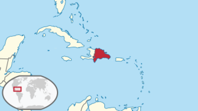
Dominican Republic Location in World Map
Here is the Dominican Republic.
Location Information of the Dominican Republic
The Dominican Republic is a country located on the island of Hispaniola in the Caribbean Sea. It shares the island with Haiti, occupying the eastern two-thirds of the island. It is the second-largest nation in the Caribbean and the largest in the Greater Antilles in terms of area and population. The country is known for its tropical climate, beautiful beaches, mountainous regions, and rich colonial history.
Latitude and Longitude
The Dominican Republic is situated between 17° and 20° N latitude and 68° and 71° W longitude. Its geographic positioning places it within the tropics, resulting in a warm climate throughout the year. The country’s longitude means it is relatively close to both the Atlantic Ocean to the north and the Caribbean Sea to the south, contributing to its maritime climate.
- Latitude: The Dominican Republic stretches from about 17° N in the south to 20° N in the north. This positioning places it well within the tropical zone, giving it a year-round warm climate and diverse ecosystems ranging from coastal areas to mountainous interiors.
- Longitude: The country’s longitude ranges from about 68° W to 71° W, placing it on the eastern side of the Caribbean, just to the east of the major shipping routes that run through the Caribbean Sea and Atlantic Ocean.
Capital City and Major Cities
The capital city of the Dominican Republic is Santo Domingo, located on the southern coast of the island. Santo Domingo is not only the political and economic center of the country but also one of the oldest continuously inhabited cities in the New World. Other important cities in the Dominican Republic include Santiago de los Caballeros, La Romana, Punta Cana, and San Pedro de Macorís.
Santo Domingo
Santo Domingo, located on the Caribbean coast, is the capital and largest city of the Dominican Republic. It has a population of approximately 3 million people in the metropolitan area and is a key hub for government, commerce, culture, and tourism.
- Economy: As the country’s economic heart, Santo Domingo is home to most of the country’s businesses, with a diverse economy that includes manufacturing, tourism, finance, and trade. The city benefits from its location along the Caribbean Sea, making it a vital center for both domestic and international trade.
- Culture and Landmarks: The city is known for its colonial architecture, particularly in the Zona Colonial (Colonial Zone), which has been recognized as a UNESCO World Heritage Site. Notable landmarks include the Alcázar de Colón, the Cathedral of Santa María la Menor, and the National Palace. Santo Domingo also has a lively arts scene, with museums, theaters, and music venues.
Santiago de los Caballeros
Santiago, the second-largest city in the Dominican Republic, is located in the Cibao Valley, surrounded by mountains. It serves as a major industrial and agricultural center.
- Economy: Santiago’s economy is driven by agriculture, especially the production of tobacco, sugar, and cocoa. The city is also a center for manufacturing, with various industries related to textiles, food processing, and chemicals.
- Culture and Landmarks: Santiago is home to various cultural landmarks, such as the Monumento a los Héroes de la Restauración (Monument to the Heroes of the Restoration), the Centro León (a cultural center and museum), and a thriving local arts scene. It is also the center of the country’s merengue and bachata music culture.
La Romana
La Romana is a port city located on the southeastern coast of the Dominican Republic. It is a key center for tourism and trade.
- Economy: La Romana is closely tied to tourism, particularly due to the presence of luxury resorts like Casa de Campo, a world-renowned golf and resort destination. The city is also home to the Altagracia Province’s sugar industry and cement production.
- Culture and Landmarks: La Romana is famous for its proximity to Altos de Chavón, a recreated Mediterranean village and cultural center. Visitors can also explore the nearby Isla Catalina and the historic sugar mills in the region.
Punta Cana
Punta Cana, located on the eastern tip of the Dominican Republic, is the country’s most famous tourist destination.
- Economy: Punta Cana is the focal point of the Dominican Republic’s tourism industry. It is home to numerous luxury resorts, golf courses, and pristine beaches. The tourism sector is the main economic driver in the region, with millions of visitors arriving each year to enjoy the area’s idyllic coastline.
- Culture and Landmarks: While Punta Cana is primarily known for its beaches and resorts, it is also near natural attractions such as the Cave of Wonders, the Indigenous Eyes Ecological Park, and several golf courses.
Time Zone
The Dominican Republic operates in the Atlantic Standard Time (AST) zone, which is UTC -4:00 year-round. The country does not observe Daylight Saving Time, so the time remains constant throughout the year.
- Standard Time: The Dominican Republic is 4 hours behind UTC (UTC -4:00). This time zone is shared with several other countries in the Caribbean and South America, including Puerto Rico and parts of Venezuela.
- Daylight Saving Time: The Dominican Republic does not change its clocks for daylight saving time, which helps maintain a consistent time zone throughout the year.
Climate
The climate in the Dominican Republic is tropical and varies somewhat depending on the region. The coastal areas tend to be warm and humid, while the interior mountains enjoy cooler temperatures.
Coastal Regions
The coastal areas of the Dominican Republic, including cities like Santo Domingo, La Romana, and Punta Cana, experience a tropical climate. The average temperature ranges from 25°C to 30°C (77°F to 86°F) year-round, with a marked rainy season from May to November.
- Rainy Season: The country experiences a pronounced rainy season during the summer months, particularly from May to October. This period coincides with the Atlantic hurricane season, which can bring storms to the region.
- Dry Season: The dry season typically lasts from November to April, with lower humidity and pleasant temperatures, making this the most popular time for tourists.
Mountainous Regions
The central mountain ranges, such as the Cordillera Central and the Sierra de Bahoruco, have a more temperate climate. Average temperatures in these areas can range from 15°C to 25°C (59°F to 77°F). The cooler temperatures in the mountains attract visitors seeking relief from the tropical heat.
Economic Status
The Dominican Republic is the largest economy in the Caribbean and Central America. The country’s economy is diversified, with sectors such as tourism, agriculture, manufacturing, and mining playing key roles.
Major Sectors
- Tourism: The tourism industry is the largest contributor to the country’s GDP. Popular destinations like Punta Cana, Santo Domingo, and Puerto Plata attract millions of tourists each year. Resorts, beaches, and cultural attractions generate significant income for the country.
- Agriculture: Agriculture plays a significant role in the Dominican economy, particularly the production of sugar, coffee, tobacco, and cocoa. The Dominican Republic is one of the world’s largest exporters of sugar and cocoa.
- Manufacturing: The Dominican Republic has a growing industrial sector, which includes textiles, pharmaceuticals, food processing, and cement. The country benefits from trade agreements such as the Central America-Dominican Republic Free Trade Agreement (CAFTA-DR), which facilitates exports to the United States and other markets.
- Mining: The Dominican Republic has significant natural resources, particularly gold and nickel. Mining is an essential part of the country’s economy, with large mining operations like Barrick Gold in the Pueblo Viejo region.
Challenges
Despite its strong economy, the Dominican Republic faces several challenges, including poverty, income inequality, and unemployment. The government has been working to address these issues through social programs, infrastructure development, and investments in education.
Tourist Attractions
The Dominican Republic offers a variety of attractions, ranging from historical landmarks to natural wonders. Some of the most popular tourist destinations include Santo Domingo, the Sierra de Bahoruco National Park, and Punta Cana.
Historical and Cultural Attractions
- Zona Colonial: The Colonial Zone in Santo Domingo is a UNESCO World Heritage Site, with buildings dating back to the 16th century. Key landmarks include the Alcázar de Colón and the Cathedral of Santa María la Menor.
- Altos de Chavón: A Mediterranean-style village located near La Romana, this cultural center is home to an amphitheater and art galleries.
Natural Attractions
- Punta Cana: Famous for its beaches, resorts, and clear waters, Punta Cana is one of the most visited destinations in the Caribbean.
- Sierra de Bahoruco National Park: A protected area that includes diverse ecosystems, ranging from tropical forests to dry savannahs, home to rare species of flora and fauna.
Eco-tourism
The Dominican Republic is a popular destination for eco-tourism, with opportunities for hiking, bird watching, caving, and exploring tropical rainforests.
Visa Requirements for U.S. Citizens
U.S. citizens visiting the Dominican Republic for tourism or business purposes do not require a visa for stays of up to 30 days. Travelers are required to present a valid passport and pay a tourist card fee upon entry.
- Tourist Card: The tourist card, which costs approximately $10 USD, is required for all visitors arriving by air. It is typically included in the cost of the airline ticket.
- Extensions: U.S. citizens can extend their stay for an additional 30 days, with the option to renew for up to a total of 90 days.
Distance to New York City and Los Angeles
- New York City: The distance from Santo Domingo to New York City is approximately 1,600 miles (2,575 kilometers). A direct flight typically takes about 3 hours.
- Los Angeles: The distance from Santo Domingo to Los Angeles is approximately 3,400 miles (5,470 kilometers). A direct flight typically takes about 5 to 6 hours.
Dominican Republic Facts
| Size | 48,671 km² |
| Residents | 10.63 million |
| Language | Spanish |
| Capital | Santo Domingo |
| Longest river | Yaque del Norte (298 km) |
| Highest mountain | Pico Duarte (3,098 m) |
| Currency | Dominican peso |


